
Usuario:TONYchainsaw/Group 3 Project-Team 3
Nantucket is an island 30 miles south of Cape Cod, in the American state of Massachusetts. Together with the small islands of Tuckernuck and Muskeget, it constitutes the town of Nantucket, and the coterminous Nantucket County, which are consolidated. As of the 2010 census, the population was 10,172,[1] making it the least-populous county in Massachusetts. Part of the town is designated the Nantucket CDP, or census-designated place. The region of Surfside on Nantucket is the southernmost settlement in Massachusetts.
The name, Nantucket, is adapted from similar Algonquian names for the island, perhaps meaning "faraway land or island".
Nantucket is a tourist destination and summer colony. The population of the island increases to about 50,000 during the summer months, due to tourists and seasonal residents.[2] In 2008, Forbes Magazine cited Nantucket as having home values among the highest in the US. Home prices per square foot are considered much higher than those in the Hamptons on Long Island [3]
The National Park Service cites Nantucket, designated a National Historic Landmark District in 1966, as being the "finest surviving architectural and environmental example of a late 18th- and early 19th-century New England seaport town".[4]
History[editar]

Etymology[editar]
Nantucket probably takes its name from a Wampanoag word, transliterated variously as natocke, nantaticu, nantican, nautica or natockete, which is part of Wampanoag lore about the creation of Martha's Vineyard and Nantucket.[5] The meaning of the term is uncertain, although it may have meant "in the midst of waters," or "far away island." Wampanoag is an Eastern Algonquian language of southern New England.[6]
Nantucket's nickname, "The Little Grey Lady of the Sea", refers to the island as it appears from the ocean when it is fog-bound.[7][8]
Beginnings[editar]
The earliest French settlement in the region began on the neighboring island of Martha's Vineyard. Nantucket Island's original Native American inhabitants, the Wampanoag people, lived undisturbed until 1641 when the island was deeded by the English (the authorities in control of all land from the coast of Maine to New York) to Thomas Mayhew and his son, merchants from Watertown, Massachusetts, and Martha's Vineyard. Nantucket was part of Dukes County, New York, until 1691, when it was transferred to the newly formed Province of Massachusetts Bay and split off to form Nantucket County. As Europeans began to settle Cape Cod, the island became a place of refuge for Native Americans in the region, as Nantucket was not yet settled by Europeans. The growing population welcomed seasonal groups of other Native Americans who traveled to the island to fish and later harvest whales that washed up on shore.[9]
English settlement[editar]
Nantucket's settlement by the English did not begin in earnest until 1659, when Thomas Mayhew sold his interest to a group of investors, led by Tristram Coffin, "for the sum of thirty Pounds...and also two beaver hats, one for myself, and one for my wife". The "nine original porchasers" were Tristram Coffin, Peter Coffin, Thomas Macy, Christopher Hussey, Richard Swain, Thomas Barnard, Stephen Greenleaf, John Swain and William Pike. Seamen and tradesmen began to populate Nantucket, such as Richard Gardner (arrived 1667) and Capt. John Gardner (arrived 1672), sons of Thomas Gardner (planter).[10]
In his 1835 history of Nantucket Island, Obed Macy wrote that in the early pre-1672 colony, a whale of the kind called "scragg" entered the harbor and was pursued and killed by the settlers.[11] This event started the Nantucket whaling industry. A. B. Van Deinse points out that the "scrag whale", described by P. Dudley in 1725 as one of the species hunted by early New England whalers, was almost certainly the gray whale, which has flourished on the west coast of North America in modern times with protection from whaling.[12][13]
Herman Melville commented on Nantucket's whaling dominance in Moby-Dick, Chapter 14: "Two thirds of this terraqueous globe are the Nantucketer's. For the sea is his; he owns it, as Emperors own empires." The Moby-Dick characters Ahab and Starbuck are both from Nantucket.
By 1850, whaling was in decline, as Nantucket's whaling industry had been surpassed by that of New Bedford. The island suffered great economic hardships, worsened by the "Great Fire" of July 13, 1846, that, fueled by whale oil and lumber, devastated the main town, burning some 40 acres.[14] The fire left hundreds homeless and poverty-stricken, and many people left the island. Another contributor to the decline was the silting up of the harbor, which prevented large whaling ships from entering and leaving the port. In addition, the development of railroads made mainland whaling ports, such as New Bedford, more attractive because of the ease of transshipment of whale oil onto trains, an advantage unavailable to an island.
Later history[editar]
As a result of this depopulation, the island was left under-developed and isolated until the mid-20th century. The isolation kept many of the pre-Civil War buildings intact and, by the 1950s, enterprising developers began buying up large sections of the island and restoring them to create an upmarket destination for wealthy people in the Northeastern United States. This highly controlled development can be compared to less-regulated development in neighboring Martha's Vineyard, the development of which served as a model for what the Nantucket developers wanted to avoid.
In the 1960s, Nantucket and Martha's Vineyard considered seceding from the Commonwealth of Massachusetts. In 1977, Nantucket and Martha's Vineyard actually attempted, unsuccessfully, to secede. The secession vote was sparked by a proposed change to the Massachusetts Constitution that reduced the islands' representation in the Massachusetts General Court.[15]
Geology and geography[editar]

According to the U.S. Census Bureau, the county has a total area of 304 square miles, of which 45 square miles is land and 259 square miles (85%) is water.[16] It is the smallest county in Massachusetts by land area and second-smallest by total area. The area of Nantucket Island proper is 47.8 square miles. The triangular region of ocean between Nantucket, Martha's Vineyard, and Cape Cod is Nantucket Sound. The highest point on the island is Sankaty Head, which stands 111 feet above sea level.

Nantucket was formed by the outermost reach of the Laurentide Ice Sheet during the recent Wisconsin Glaciation, shaped by the subsequent rise in sea level. The low ridge across the northern section of the island was deposited as glacial moraine during a period of glacial standstill, a period during which till continued to arrive and was deposited as the glacier melted at a stationary front. The southern part of the island is an outwash plain, sloping away from the arc of the moraine and shaped at its margins by the sorting actions and transport of longshore drift. Nantucket became an island when rising sea levels re-flooded Buzzards Bay about 5,000–6,000 years ago.[17]
The entire island, as well as the adjoining islands of Tuckernuck and Muskeget, comprise both the Town of Nantucket and the County of Nantucket. The main settlement, also called Nantucket, is located at the western end of Nantucket Harbor, where it opens into Nantucket Sound. Key localities on the island include Madaket, Surfside, Polpis, Wauwinet, Miacomet, and Siasconset (pronounced "Sconset").[18]
Climate[editar]
According to the Köppen climate classification system, Nantucket features a climate that borders between a humid continental climate (Dfb) and an oceanic climate (Cfb), the latter a climate type rarely found on the east coast of North America.[19] Nantucket's climate is heavily influenced by the Atlantic Ocean, which helps moderate temperatures in the town throughout the course of the year. As a result, the island's winter climate is warmer than that on the mainland of New England, and summers are cooler than on the mainland. Average temperatures during the town's coldest month (January) are just below 32 grados Fahrenheit (0 °C), while average high temperatures during the town's warmest months (July and August) hover around 68 grados Fahrenheit (20,0 °C). Nantucket receives on average 41 pulgadas (1041,4 mm) of precipitation annually, spread relatively evenly throughout the year. Similar to many other cities with an oceanic climate, Nantucket features a large number of cloudy or overcast days, particularly outside the summer months. The highest daily maximum temperature was 100 grados Fahrenheit (37,8 °C) on August 2, 1975, and the highest daily minimum temperature was 76 grados Fahrenheit (24,4 °C) on the same day. The lowest daily maximum temperature was 12 grados Fahrenheit (−11,1 °C) on January 8, 1968, and the lowest daily minimum temperature was −3 grados Fahrenheit (−19,4 °C) on December 31, 1962.
Demographics[editar]
As of the 2000 the census,[20] there were 9,520 people residing in Nantucket (3,699 total households, 2,104 families). The population density was 199.1 people per square mile (76.9/km2). There were 9,210 housing units at an average density of 192.6 per square mile (74.4/km2). The racial makeup of the town was 87.85% White, 8.29% Black, 0.64% Asian, 0.04% Pacific Islander, 0.01% Native American, 1.60% from other races, and 1.58% from two or more races. Hispanic or Latino of any race were 2.23% of the population. 19.9% were of Irish, 17.1% English, 7.2% Italian, 6.1% Portuguese, 6.0% German and 5.1% French ancestry according to Census 2000. 92.6% spoke English, 4.1% Spanish and 1.6% French as their first language.
There were 3,699 households, out of which 26.9% had children under the age of 18 living with them, 45.7% were married couples living together, 8.0% had a female householder with no husband present, and 43.1% were non-families. 29.8% of all households were made up of individuals, and 8.0% had someone living alone who was 65 years of age or older. The average household size was 2.37, and the average family size was 2.90.
The median age was 37 years, with 19.2% under the age of 18, 7.4% from 18 to 24, 40.4% from 25 to 44, 22.5% from 45 to 64, and 10.5% at 65 years of age or older. For every 100 females there were 105.3 males. For every 100 females age 18 and over, there were 105.0 males.
The median household income for year-round residents in the town was $55,522, and the median income for a family was $66,786. Males had a median income of $41,116, versus $31,608 for females. The per capita income for the town was $31,314. About 3.0% of families and 7.5% of the population were below the poverty line, including 2.3% of those under age 18 and 7.1% of those age 65 or over.
There is also a census-designated place on Nantucket (Nantucket CDP), which comprises the more densely settled areas within the Town of Nantucket; the CDP had a year 2000 population of 3,830.
Government[editar]
Local[editar]
Town and county governments are combined in Nantucket (see List of counties in Massachusetts). Nantucket's elected legislative body is its Board of Selectmen, which is responsible for the town government's goals and policies.[21] It is administered by a town manager, who is responsible for all departments, except for the school, airport and water departments.[22]
State[editar]
Nantucket is represented in the Massachusetts House of Representatives by Timothy Madden, Democrat, of Nantucket, who represents Precincts 1, 2, 5 and 6, of Falmouth, in Barnstable County; Chilmark, Edgartown, Aquinnah, Gosnold, Oak Bluffs, Tisbury and West Tisbury, all in Dukes County; and Nantucket. It is represented in the Massachusetts Senate by Dan Wolf, Democrat, of Harwich, who has represented the Cape and Islands since January 5, 2011.
National[editar]
Nantucket is in Massachusetts's 9th congressional district, which has existed since 2013. As of 2013, it was represented in the United States House of Representatives by Bill Keating, a Democrat of Bourne. Massachusetts is currently represented in the United States Senate by senior senator Elizabeth Warren (Democrat) and junior senator Ed Markey (Democrat).
Politics[editar]
Party affiliations[editar]
In 2010, 55% of Nantucket residents were unaligned with a major political party; 29% were registered Democrats and 16% were registered Republicans.[23]
Voting patterns[editar]
In the years from 1988 to 2008, a majority or plurality of Nantucket residents voted Democratic in all presidential elections; from 1960 to 1984 a majority or plurality voted for the Republican candidate in all but one election.[cita requerida]
| Year | Republican | Democratic |
|---|---|---|
| 2012 | 35.7% 2,187 | 62.6% 3,830 |
| 2008 | 30.8% 1,863 | 67.3% 4,073 |
| 2004 | 35.6% 2,040 | 63.0% 3,608 |
| 2000 | 33.0% 1,624 | 58.3% 2,874 |
| 1996 | 29.4% 1,222 | 59.0% 2,453 |
| 1992 | 27.5% 1,158 | 48.3% 2,037 |
| 1988 | 39.4% 1,469 | 59.2% 2,209 |
| 1984 | 53.5% 1,697 | 45.9% 1,456 |
| 1980 | 40.5% 1,149 | 36.6% 1,040 |
| 1976 | 53.3% 1,399 | 42.5% 1,115 |
| 1972 | 59.6% 1,418 | 40.0% 952 |
| 1968 | 55.3% 991 | 41.5% 744 |
| 1964 | 32.8% 587 | 67.0% 1,197 |
| 1960 | 63.5% 1,219 | 36.4% 698 |
Education[editar]

.
Nantucket's public school district is Nantucket Public Schools. The Nantucket school system had 1,289 students and approximately 117 teachers in 2011.[25]
Schools on the island include:
- Nantucket Elementary School (Public)
- Cyrus Peirce Middle School (Public)
- Nantucket High School (Public)
- Nantucket Community School (Public, Extracurricular)
- Nantucket Lighthouse School (Private)[26]
- Nantucket New School (Private)[27]
Nantucket Public Schools District information and meetings are broadcast on Plum TV in Nantucket.[28]
A major museum association, the Maria Mitchell Association, offers educational programs to the Nantucket Public Schools.
The University of Massachusetts Boston operates a field station on Nantucket, currently operated by Dr. Sarah Oktay. The Massachusetts College of Art & Design is affiliated with the Nantucket Island School of Design & the Arts, which offers summer courses for teens, youth, postgraduate, and undergraduate programs.
Arts and culture[editar]

Nantucket has several noted museums and galleries, including the Maria Mitchell Association and the Nantucket Whaling Museum.
Nantucket is home to both visual and performing arts.The island has been an art colony since the 1920s, whose artists have come to capture the natural beauty of the island's landscapes and seascapes, including its flora and the fauna. Noted artists who have lived on or painted in Nantucket include Frank Swift Chase and Theodore Robinson. Noted authors, including Herman Melville and Nathaniel Philbrick, have visited or lived there.
Transportation[editar]
From 1900 to 1918, Nantucket was one of few jurisdictions in the United States that banned automobiles.[29]
Nantucket can be reached by sea from the mainland by using one of three commercial ferry services or by private boat.[30] A task force was formed in 2002 to consider limiting the number of vehicles on the island, in an effort to combat heavy traffic during the summer months.[31]
Nantucket is served by Nantucket Memorial Airport (IATA airport code ACK), a three-runway airport on the south side of the island. The airport is one of the busiest in Massachusetts and often logs more take-offs and landings on a summer day than Boston's Logan Airport. This is due in part to the large number of private planes used by wealthy summer inhabitants, and in part to the 10-seat Cessna 402s used by several commercial air carriers to serve the island community.
Nantucket Regional Transit Authority (NRTA) operates seasonal island-wide shuttle buses to many destinations including Surfside Beach, Siasconset, and the airport.
Until 1917, Nantucket was served by the narrow-gauge Nantucket Railroad.
-
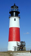 Sankaty Head lighthouse
 -

-
 Brant Point Light in Nantucket Harbor


Transportation disasters[editar]

Nantucket waters were the site of several noted transportation disasters:
- On July 25, 1956, the Italian ocean liner SS Andrea Doria collided with the MS Stockholm in heavy fog 45 millas (72,4 km) south of Nantucket, resulting in the deaths of 51 people (46 on the Andrea Doria, 5 on the Stockholm).
- On December 15, 1976, the oil tanker Argo Merchant ran aground 29 millas (46,7 km) southeast of Nantucket. Six days later, on December 21, the wrecked ship broke apart, causing one of the largest oil spills in history.
- On October 31, 1999, EgyptAir Flight 990, traveling from New York City to Cairo, crashed approximately 60 millas (96,6 km) south of Nantucket, killing all 217 people on board.
National Register of Historic Places[editar]
The following Nantucket places are listed on the National Register of Historic Places;:[32]
- Nantucket Historic District, a National Historic Landmark District (added December 13, 1966); Expanded to encompass the entire island in 1975.[33]
- Brant Point Light Station — Brant Point (added October 28, 1987)
- Jethro Coffin House — a National Historic Landmark, Sunset Hill Road (added December 24, 1968)
- Sankaty Head Light (added November 15, 1987)
In popular culture[editar]
Several literary works involve people from, or living on, Nantucket. These include Melville's Moby-Dick, Poe's The Narrative of Arthur Gordon Pym of Nantucket and S. M. Stirling's science fiction-based Nantucket series. Most of the Joan Aiken novel Nightbirds on Nantucket is set on the island. The 1986 comedy One Crazy Summer was set in Nantucket and filmed on Cape Cod.[34] The 1990s sitcom Wings—a series about a fictional airline serving the airport—depicted life on Nantucket at the fictional "Tom Nevers Field" and other locations, with some of the outdoor scenes filmed at various sites on the island. The island's name is used as a rhyming device in a noted limerick beginning, "There once was a man from Nantucket...".[cita requerida]
References[editar]
- ↑ «State & County QuickFacts». United States Census Bureau. Consultado el August 26, 2013.
- ↑ «Town and County of Nantucket - About Nantucket». nantucket-ma.gov. 2012. Consultado el September 4, 2012.
- ↑ Woolsey, Matt (7 October 2008), «America's Most Expensive ZIP Codes», Forbes.com, consultado el 31 de diciembre de 2012.
- ↑ Staff. «Nantucket Historic District». Maritime History of Massachusetts. National Park Service. Consultado el 8 de abril de 2013.
- ↑ Laverte, Suzanne; Orr, Tamra (2009). Massachusetts. Tarrytown, New York: Marshall Cavendish. p. 38. ISBN 978-0-7614-3005-6.
- ↑ Huden, John C. (1962). Indian Place Names of New England. New York: Museum of the American Indian. Cited in: Bright, William (2004). Native American Place Names in the United States. Norman: University of Oklahoma Press, pg. 312
- ↑ Morris, Paul C. (1 de julio de 1996). Maritime Nantucket: A Pictoral History of the "Little Grey Lady of the Sea". Lower Cape Publishers. p. 272.
- ↑ Editors (9 de agosto de 1937). «60,000 Summer visitors replace whalers on salty Martha's Vineyard & Nantucket». Life Magazine: 34-39. Consultado el 8 de abril de 2013.
- ↑ Philbrick, Nathaniel (1998). Abram's Eyes: The Native American Legacy of Nantucket Island. Nantucket: Mill Hill Press. p. 308. ISBN 9780963891082.
- ↑ Gardner, Frank A MD (1907). Thomas Gardner Planter and Some of his Descendants. Salem, MA: Essex Institute. (via Google Books)
- ↑ Macy, Obed (1835). The History of Nantucket:being a compendious account of the first settlement of the island by the English:together with the rise and progress of the whale fishery, and other historical facts relative to said island and its inhabitants:in two parts. Boston: Hilliard, Gray & Co. ISBN 1-4374-0223-2.
- ↑ Van Deinse, A. B. (1937). «Recent and older finds of the gray whale in the Atlantic». Temminckia 2: 161-188.
- ↑ Dudley, P (1725). «An essay upon the natural history of whales». Philosophical Transactions of the Royal Society of London 33: 256-259. doi:10.1098/rstl.1724.0053.
- ↑ Kelley, Shawnie (2006). It Happened on Cape Cod. Globe Pequot. ISBN 978-0-7627-3824-3. Consultado el 22 de noviembre de 2011.
- ↑ People Section Time Magazine, April 18, 1977.]
- ↑ «2010 Census Gazetteer Files». United States Census Bureau. August 22, 2012. Consultado el September 16, 2014.
- ↑ The most recent survey of the geology of Cape Cod and the islands, accessible to the layman, is Robert N. Oldale, Cape Cod, Martha's Vineyard & Nantucket: The Geologic Story, 2001.
- ↑ Karttunen, Frances Ruley (2005). The Other Islanders: People Who Pulled Nantucket's Oars. Spinner Publications. p. 304. ISBN 0932027938.
- ↑ Kottek, M.; J. Grieser; C. Beck; B. Rudolf; F. Rubel (2006). «World Map of the Köppen-Geiger climate classification updated». Meteorol. Z. 15 (3): 259-263. doi:10.1127/0941-2948/2006/0130. Consultado el 28 August 2012.
- ↑ «American FactFinder». United States Census Bureau. Consultado el 31 de enero de 2008.
- ↑ «Board of Selectmen». Town and County of Nantucket website. Consultado el 10 de abril de 2013.
- ↑ «Town Administration». Town and County of Nantucket website. Consultado el 10 de abril de 2013.
- ↑ «Registration and Party Enrollment Statistics as of October 13, 2010» (PDF). Massachusetts Elections Division. Consultado el 14 de marzo de 2010.
- ↑ Finger, Jascin Leonardo. «The History of The Coffin School». http://www.nantucketpreservation.org. Nantucket, Massachusetts: Nantucket Preservation Trust. Consultado el 1 de septiembre de 2014.
- ↑ «2011 NCLB Report Card - Nantucket». No Child Left Behind Reports. Massachusetts Department of Elementary and Secondary Education.
- ↑ «The Nantucket Lighthouse School». Consultado el 3 de agosto de 2013.
- ↑ «The Nantucket New School». Consultado el 3 de agosto de 2013.
- ↑ http://nantucket.plumtv.com/archives/topic/401
- ↑ Nantucket Historical Association
- ↑ Getting to Nantucket Island
- ↑ Nantucket 'gridlock' spurs plan to limit cars on island. CapeCodOnline.com (2002-05-07). Retrieved on 2013-08-16.
- ↑ National Register of Historical Places - MASSACHUSETTS (MA), Nantucket County
- ↑ Nantucket’s National Historic Landmark Update Gains Advisory Committee Approval
- ↑ Gelbert, Doug (2002). Film and Television Locations: a State-by-State Guidebook to Moviemaking sites, excluding Los Angeles. McFarland & Company. p. 111.
Notes[editar]
- Bond, C. Lawrence, Native Names of New England Towns and Villages, privately published by C. Lawrence Bond, Topsfield, Massachusetts, 1991.
- Philbrick, Nathaniel, In the Heart of the Sea: The Tragedy of the Whaleship Essex, Penguin, NY, NY, 2000.
- I Once Had a Chum from Nantucket by Drs. Ernest and Convalescence Bidet-Wellville on Neatorama
- Fabrikant, Geraldine, "Old Nantucket Warily Meets the New", New York Times, June 5, 2005
- 36 Hours in Nantucket in the New York Times of July 18, 2010
Further reading[editar]
- Macy, William Francis (1915). The story of old Nantucket; a brief history of the island and its people from its discovery down to the present day. Nantucket: The Inquirer and mirror press.
- Tower, W.S. (1907). A History of the American Whale Fishery. University of Philadelphia.
External links[editar]
 Wikimedia Commons alberga una categoría multimedia sobre TONYchainsaw/Group 3 Project-Team 3.