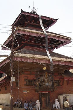
Lubhu
| Lubhu | ||
|---|---|---|
| Pueblo | ||
 | ||
|
Localización de Lubhu en Nepal | ||
| Coordenadas | 27°38′00″N 85°23′00″E / 27.63333333, 85.38333333 | |
| Entidad | Pueblo | |
| • País |
| |
| • Distrito | Lalitpur | |
| Superficie | ||
| • Total | 6,4 km² | |
| Población (2015) | ||
| • Total | 12 786 hab. | |
| • Densidad | 1997 hab./km² | |
| Huso horario | UTC+05:45 | |
| Sitio web oficial | ||
Lubhu es un pueblo ubicado en el distrito de Lalitpur, Nepal.[1][2][3][4][5][6]
Superficie[editar]
Cuenta con una superficie de 6,4 kilómetros cuadrados.[1]
Demografía[editar]
Hasta 2015 la población era de 12 786 habitantes,[1] con una densidad de población de 1997 habitantes por kilómetro cuadrado.[1] Con una población masculina y femenina de 6279 (49,1%) y 6507 (50,9%) respectivamente.[1]
| Gráfica de evolución demográfica de Lubhu entre 1975 y 2015 |
 |
|
Datos según el Centro Común de Investigación.[1] |
Referencias[editar]
- ↑ a b c d e f «Lalitpur village, Nepal» (en inglés). DatosCiudad - City Facts. Consultado el 2 de diciembre de 2023.
- ↑ «National Population Census 2011 Household and Population by Sex Ward Level» (en inglés). Central Bureau of Statistics Thapathali, November, 2012. Consultado el 2 de diciembre de 2023.
- ↑ «VDC’s population.» (en inglés). National Association of Village Development Committees in Nepal (NAVIN). p. 47. Consultado el 2 de diciembre de 2023.
- ↑ «National Population and Housing Census 2011» (en inglés). Volume 02, National Population and Housing Census (NPHC). Central Bureau of Statistics (Nepal) - Comisión Nacional de Planificación de Nepal, 2012. p. 40. Consultado el 2 de diciembre de 2023.
- ↑ «Laliptur - National Population and Housing Census 2011» (en inglés). Government of Nepal. Comisión Nacional de Planificación de Nepal, Volume 06, NPHC2011 (2014). Consultado el 2 de diciembre de 2023.
- ↑ «Nepal Census - Lalitpur» (en inglés). Himalaya Digital: Contribuciones a los Estudios Nepalíes. Consultado el 2 de diciembre de 2023.

