
Archivo:SJU Diagram.JPG
Tamaño de esta previsualización: 392 × 600 píxeles. Otras resoluciones: 157 × 240 píxeles · 517 × 791 píxeles.
Ver la imagen en su resolución original (517 × 791 píxeles; tamaño de archivo: 57 kB; tipo MIME: image/jpeg)
Resumen
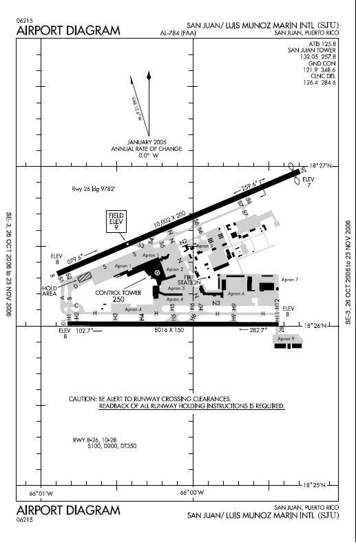
| Descripción |
English: FAA Airport Diagram(link at bottom of the page)
commons:category:Luis Muñoz Marín International Airport commons:category:Federal Aviation Administration commons:category:MapsEspañol: Diagrama del Aeropuerto Internacional Luis Muñoz Marín de la Administración Federal de Aviación |
| Fuente | FAA |
| Autor | FAA |
Around past April-May, I uploaded this image updated, that included the new taxiway on the south of the airport. The updated version appeared on the "file history" section. I don't know why it was removed. Can anyone update this image?, and that have better resolution too?
Licencia
This image or file is a work of a Federal Aviation Administration employee, taken or made as part of that person's official duties. As a work of the U.S. federal government, the image is in the public domain in the United States.
|
 |
Registro original de carga
Aquí se muestra la página de descripción original. Los siguientes nombres de usuario se refieren a en.wikipedia.
- 2006-10-28 15:21 Djxixa 517×791× (58780 bytes) FAA Airport Diagram(link at bottom of the page)
Historial del archivo
Haz clic sobre una fecha y hora para ver el archivo tal como apareció en ese momento.
| Fecha y hora | Miniatura | Dimensiones | Usuario | Comentario | |
|---|---|---|---|---|---|
| actual | 17:05 29 abr 2010 | | 517 × 791 (57 kB) | File Upload Bot (Magnus Manske) | {{BotMoveToCommons|en.wikipedia|year={{subst:CURRENTYEAR}}|month={{subst:CURRENTMONTHNAME}}|day={{subst:CURRENTDAY}}}} {{Information |Description={{en|FAA Airport Diagram(link at bottom of the page) [[:en:commons:category:Luis Muñoz Marín Internation |
Usos del archivo
La siguiente página usa este archivo:
Uso global del archivo
Las wikis siguientes utilizan este archivo:
- Uso en ast.wikipedia.org
- Uso en ca.wikipedia.org
- Uso en fa.wikipedia.org
- Uso en fr.wikipedia.org
- Uso en ja.wikipedia.org
- Uso en ru.wikipedia.org
- Uso en tg.wikipedia.org