
Archivo:United Kingdom ESA361630.tiff

Ver la imagen en su resolución original (4000 × 3496 píxeles; tamaño de archivo: 80,04 MB; tipo MIME: image/tiff)
Resumen
| Descripción |
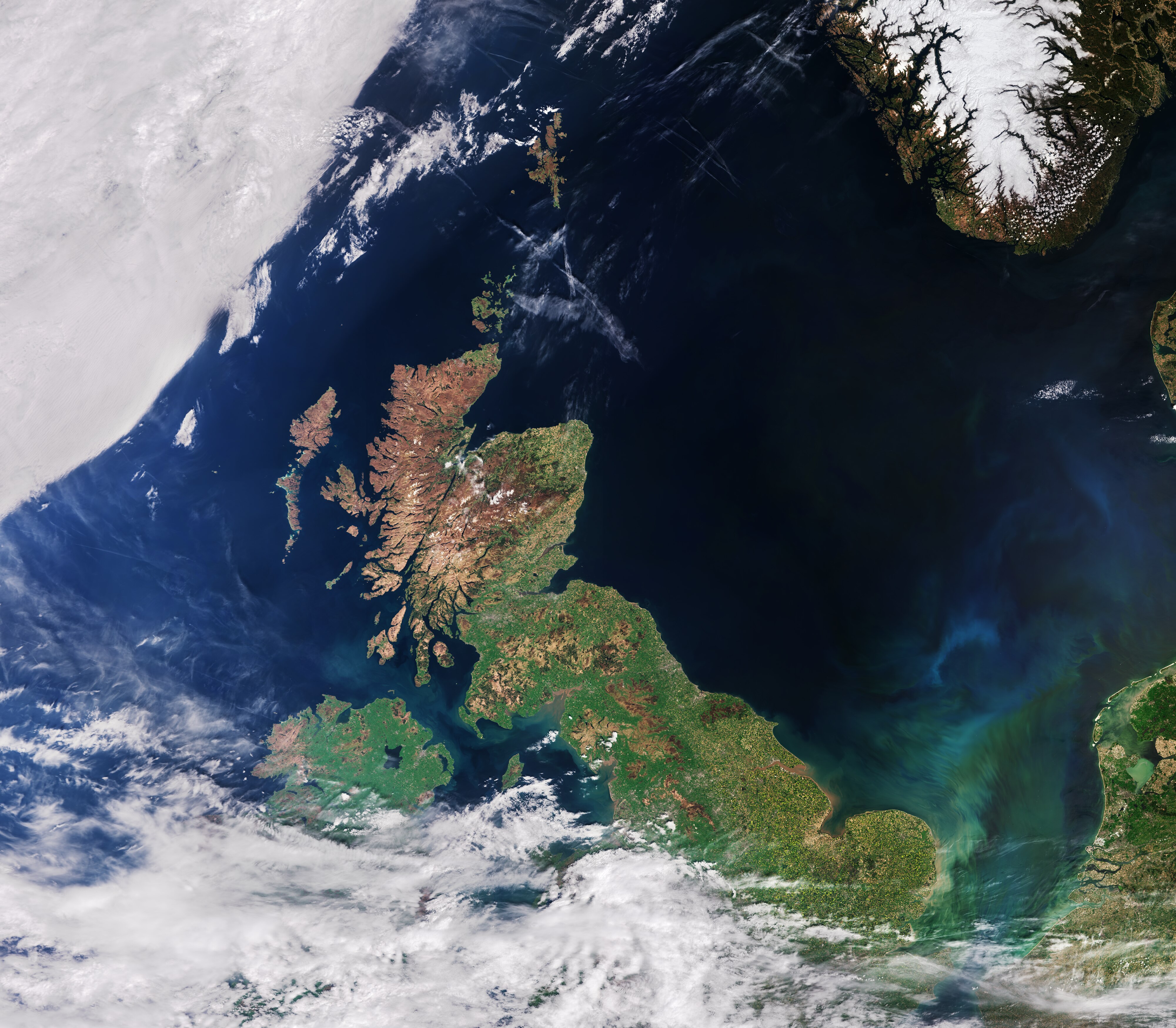
English: The recently launched Sentinel-3A satellite takes us over the United Kingdom, in this false-colour image acquired on 9 May.
Made up of England, Scotland, Wales and Northern Ireland, the UK is an island nation in northwestern Europe. At the top centre of the image, we can see aircraft contrails – water vapour condenses around the small particles in the aircraft exhaust to form ice crystals. The result is the formation of an elongated cloud-like condensation trail in the sky, unmistakable in the centre of the image. At top right, some snow cover in southern Norway is still evident. At bottom right, part of the Netherlands with the unmistakable 700 sq km Lake Markermeer is clearly visible. In the southern North Sea/English Channel, an algal bloom is distinguishable in shades of light blue and green. Meanwhile, closer to the coast we can see brown sediments where rivers and streams run into the sea. The Scottish Highlands at the tip of the United Kingdom appear light brown, representing bare soil and rock formations, with some vegetation. The rest of the island, as well as the visible part of Ireland, are very green, representing dense vegetation. Sentinel-3A’s Ocean and Land Colour Instrument is a new eye on Earth, monitoring ocean ecosystems, supporting crop management and agriculture, and providing estimates of atmospheric aerosol and clouds – all of which will bring significant benefits to society through more informed decision-making. This image is also featured on the Earth from Space video programme. |
| Fecha | |
| Fuente | http://www.esa.int/spaceinimages/Images/2016/06/United_Kingdom |
| Autor | European Space Agency |
| Permiso (Reutilización de este archivo) |
Contains modified Copernicus Sentinel data [2016]/ processed by ESA,CC BY-SA 3.0 IGO |
| Otras versiones |
|
| Title | United Kingdom |
| Location | United Kingdom |
| Set | Earth observation image of the week |
| Mission | Sentinel-3 |
| Activity | Observing the Earth |

Licencia
- Eres libre:
- de compartir – de copiar, distribuir y transmitir el trabajo
- de remezclar – de adaptar el trabajo
- Bajo las siguientes condiciones:
- atribución – Debes otorgar el crédito correspondiente, proporcionar un enlace a la licencia e indicar si realizaste algún cambio. Puedes hacerlo de cualquier manera razonable pero no de manera que sugiera que el licenciante te respalda a ti o al uso que hagas del trabajo.
- compartir igual – En caso de mezclar, transformar o modificar este trabajo, deberás distribuir el trabajo resultante bajo la misma licencia o una compatible como el original.
Historial del archivo
Haz clic sobre una fecha y hora para ver el archivo tal como apareció en ese momento.
| Fecha y hora | Miniatura | Dimensiones | Usuario | Comentario | |
|---|---|---|---|---|---|
| actual | 14:45 6 may 2017 |  | 4000 × 3496 (80,04 MB) | Fæ | == {{int:filedesc}} == {{information | description = {{en|1=The recently launched Sentinel-3A satellite takes us over the United Kingdom, in this false-colour image acquired on 9 May. Made up of England, Scotland, Wales and Northern Ireland, the UK is... |
Usos del archivo
La siguiente página usa este archivo:
Uso global del archivo
Las wikis siguientes utilizan este archivo:
- Uso en en.wikipedia.org
- Uso en fa.wikipedia.org
- Uso en he.wikipedia.org
- Uso en www.wikidata.org