
Archivo:St Anne, Limehouse (36640179641).jpg

Ver la imagen en su resolución original (2681 × 3648 píxeles; tamaño de archivo: 5,52 MB; tipo MIME: image/jpeg)
.jpg?uselang=es)
Resumen
| Descripción |
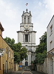
St Anne's Limehouse was formed from part of the parish of St. Dunstan's Stepney, prior to the 18th century a large (but then thinly populated) East London parish that extended all the way down to the Thames River. As the population of London increased, growing parishes were subdivided. In 1709 a new parish in Limehouse was formed from part of the parish of St. Dunstan. The church may be named for Queen Anne as she raised money for it by taxing coal passing along the River Thames. The building was designed by Nicholas Hawksmoor, as one of twelve churches built to serve the needs of the rapidly expanding population of London in the 18th century. The scheme never met its original target, but those built were also known as the Queen Anne Churches. The building was completed in 1727 and consecrated in 1730. Queen Anne decreed that as the new church was close to the river it would be a convenient place of registry for sea captains to register vital events taking place at sea. Therefore, she gave St. Anne's Church the right to display the second most senior ensign of the Royal Navy, the White Ensign. The prominent tower with its golden ball on the flagpole became a Trinity House "sea mark" on navigational charts, and the Queen's Regulations still permit St. Anne's Limehouse to display the White Ensign 24 hours a day, 365 days a year. Hawksmoor, who worked with Wren and Vanburgh, has been 'rediscovered' in recent years. His style is innovative and eclectic. Some have portrayed his churches as centres of gloom and mystery, full of occult and morbid energies and pagan symbols, linked to ancient lay lines and to murders in Whitechapel and on the notorious Ratcliffe Highway (which now links the City and Canary Wharf). |
| Fecha | |
| Fuente | St Anne, Limehouse |
| Autor | Amanda Slater from Coventry, West Midlands, UK |
| Posición de la cámara | | Ubicación de esta y otras imágenes en: OpenStreetMap |
|---|
.jpg¶ms=051.510311_N_-000.030169_E_globe:Earth_type:camera_source:Flickr_&language=es)
Licencia
- Eres libre:
- de compartir – de copiar, distribuir y transmitir el trabajo
- de remezclar – de adaptar el trabajo
- Bajo las siguientes condiciones:
- atribución – Debes otorgar el crédito correspondiente, proporcionar un enlace a la licencia e indicar si realizaste algún cambio. Puedes hacerlo de cualquier manera razonable pero no de manera que sugiera que el licenciante te respalda a ti o al uso que hagas del trabajo.
- compartir igual – En caso de mezclar, transformar o modificar este trabajo, deberás distribuir el trabajo resultante bajo la misma licencia o una compatible como el original.
| Esta imagen fue publicada en Flickr por amandabhslater en https://flickr.com/photos/15181848@N02/36640179641 (archivo). La imagen fue revisada el 17 de noviembre de 2017 por el robot FlickreviewR 2 y confirmó tener licencia bajo los términos de cc-by-sa-2.0. |
Historial del archivo
Haz clic sobre una fecha y hora para ver el archivo tal como apareció en ese momento.
| Fecha y hora | Miniatura | Dimensiones | Usuario | Comentario | |
|---|---|---|---|---|---|
| actual | 08:03 17 nov 2017 | | 2681 × 3648 (5,52 MB) | Ham II | Transferred from Flickr via Flickr2Commons |
Usos del archivo
La siguiente página usa este archivo:
Uso global del archivo
Las wikis siguientes utilizan este archivo:
- Uso en arz.wikipedia.org
- Uso en cs.wikipedia.org
- Uso en de.wikipedia.org
- Uso en de.wikivoyage.org
- Uso en en.wikipedia.org
- Uso en et.wikipedia.org
- Uso en it.wikipedia.org
- Uso en ru.wikipedia.org
- Uso en uk.wikipedia.org
- Uso en www.wikidata.org
.jpg)