
Archivo:Jerusalem map Green Line.png
No se dispone de una resolución más alta.
Jerusalem_map_Green_Line.png (328 × 370 píxeles; tamaño de archivo: 35 kB; tipo MIME: image/png)
Resumen
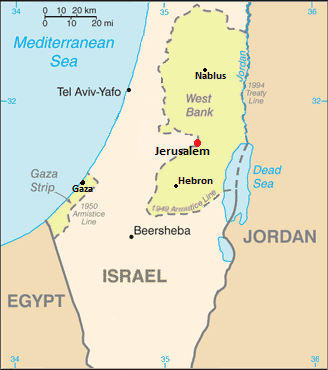
| Descripción | Map showing Jerusalem straddling the Green Line |
| Fecha | (UTC) |
| Fuente | |
| Autor |
|
| Esta es una imagen retocada, lo que significa que ha sido alterada digitalmente de su versión original. Modificaciones: changed color of WB/Gaza, removed several cities and notes. La original se puede ver aquí: Cia-is-map2.gif. Las modificaciones las hizo Nableezy.
|
Licencia
Esta imagen se encuentra en el dominio público ya que su contenido proviene de CIA World Factbook, un trabajo de la Agencia Central de Inteligencia de los Estados Unidos de América.
|
 |
Registro original de carga
This image is a derivative work of the following images:
- File:Cia-is-map2.gif licensed with PD-USGov-CIA-WF
- 2006-08-13T22:27:27Z Milan.sk 330x715 (21389 Bytes)
Uploaded with derivativeFX
Historial del archivo
Haz clic sobre una fecha y hora para ver el archivo tal como apareció en ese momento.
| Fecha y hora | Miniatura | Dimensiones | Usuario | Comentario | |
|---|---|---|---|---|---|
| actual | 20:26 8 dic 2011 | | 328 × 370 (35 kB) | Nableezy | upload under a different file name if you insist |
| 18:01 8 dic 2011 |  | 328 × 370 (37 kB) | Someone35 | fixed | |
| 18:00 8 dic 2011 |  | 328 × 370 (37 kB) | Someone35 | Now there's more contrast between Israel, the West bank and other countries. | |
| 01:40 4 dic 2011 |  | 328 × 370 (35 kB) | Nableezy | reposition scale, label for Mediterranean Sea and Tel Aviv | |
| 22:15 3 dic 2011 |  | 328 × 370 (35 kB) | Nableezy | cropped | |
| 05:08 3 dic 2011 |  | 328 × 715 (57 kB) | Nableezy | Removed Ashqelon, Elat, added Tel Aviv, Gaza, modified dot for Jerusalem and placement and size of word "Jerusalem" | |
| 16:06 2 dic 2011 |  | 328 × 715 (63 kB) | Nableezy | == {{int:filedesc}} == {{Information |Description=Map showing Jerusalem straddling the Green Line |Source=*File:Cia-is-map2.gif |Date=2011-12-02 16:04 (UTC) |Author=*File:Cia-is-map2.gif: CIA *derivative work: ~~~ |Permission= |other_versions= |
Usos del archivo
La siguiente página usa este archivo:
Uso global del archivo
Las wikis siguientes utilizan este archivo:
- Uso en en.wikipedia.org
- Uso en lt.wiktionary.org
- Uso en nl.wikipedia.org
- Uso en pnb.wikipedia.org
- Uso en pt.wikipedia.org
- Uso en tr.wikipedia.org
- Uso en ur.wikipedia.org