
Archivo:Hawaii hotspot.jpg
Tamaño de esta previsualización: 800 × 337 píxeles. Otras resoluciones: 320 × 135 píxeles · 640 × 270 píxeles · 1500 × 632 píxeles.
Ver la imagen en su resolución original (1500 × 632 píxeles; tamaño de archivo: 452 kB; tipo MIME: image/jpeg)
| Descripción |
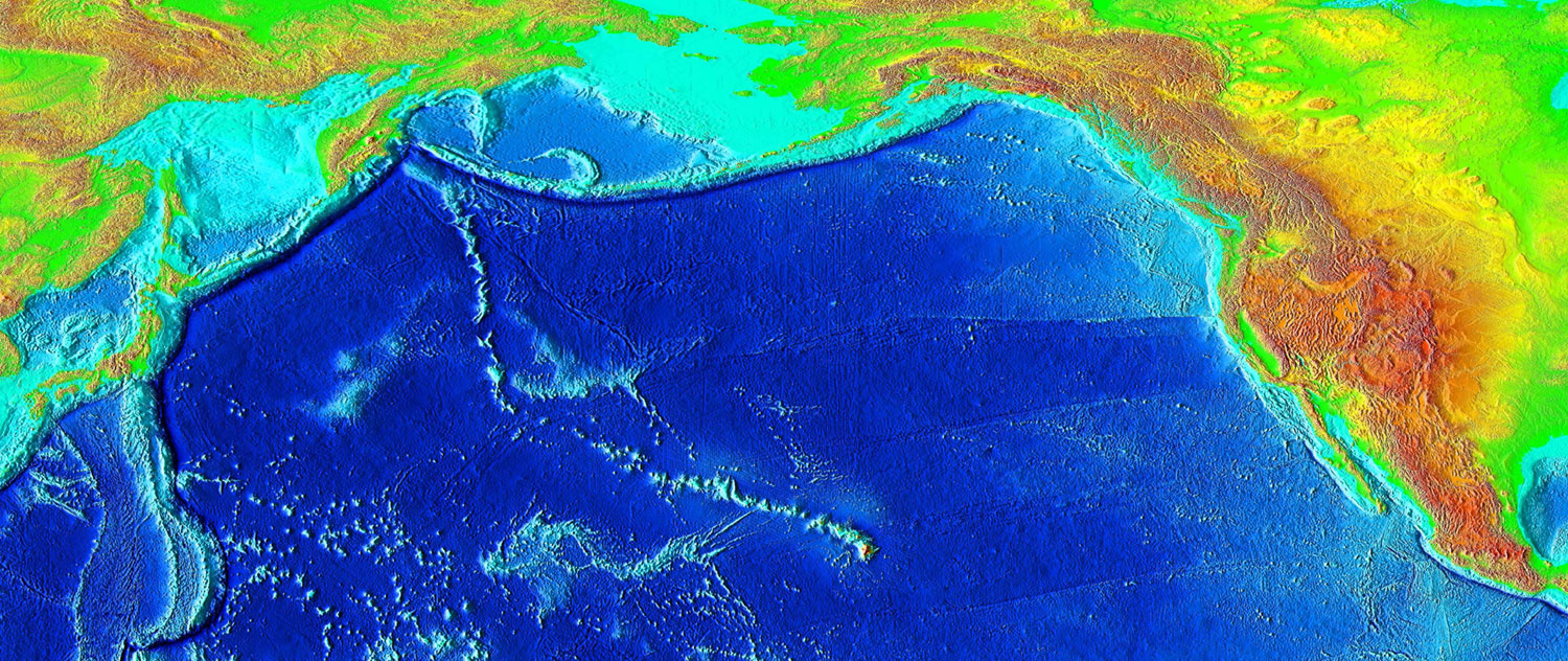
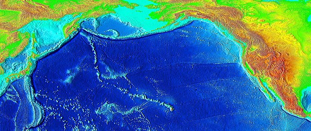
English: The trail of underwater mountains created as the tectonic plate moved across the Hawaii hotspot over millions of years, known as the Hawaiian-Emperor seamount chain, or the Emperor Seamounts. |
|||
| Fecha | ||||
| Fuente | http://www.ngdc.noaa.gov/mgg/image/2minrelief.html | |||
| Autor | National Geophysical Data Center/USGS | |||
| Permiso (Reutilización de este archivo) |
|
| Annotations | This image is annotated: View the annotations at Commons |
Historial del archivo
Haz clic sobre una fecha y hora para ver el archivo tal como apareció en ese momento.
| Fecha y hora | Miniatura | Dimensiones | Usuario | Comentario | |
|---|---|---|---|---|---|
| actual | 04:42 7 mar 2006 | | 1500 × 632 (452 kB) | Interiot~commonswiki | Higher resolution |
| 04:26 7 mar 2006 |  | 1000 × 421 (201 kB) | Interiot~commonswiki | The trail of underwater mountains created as the the tectonic plate moved across the Hawaii hotspot over millions of years. Source: http://www.ngdc.noaa.gov/mgg/image/2minrelief.html |
Usos del archivo
Las siguientes páginas usan este archivo:
Uso global del archivo
Las wikis siguientes utilizan este archivo:
- Uso en ba.wikipedia.org
- Uso en bg.wikipedia.org
- Uso en ca.wikipedia.org
- Uso en de.wikipedia.org
- Uso en en.wikipedia.org
- Hawaiian Islands
- Talk:Hawaiian Islands
- Hawaiian–Emperor seamount chain
- Evolution of Hawaiian volcanoes
- Hotspot (geology)
- Portal:Geography/Featured picture/2007, week 2
- Hawaii hotspot
- Portal:Geography/Featured picture archive/2007
- User talk:Resident Mario
- Wikipedia:WikiProject Seamounts/Images
- List of volcanoes in the Hawaiian–Emperor seamount chain
- Plate reconstruction
- Wikipedia:Graphics Lab/Map workshop/Archive/Apr 2012
- Wikipedia:Today's featured list/October 2022
- Wikipedia:Today's featured list/October 21, 2022
- Wikipedia:Main Page history/2022 October 21
- Wikipedia:Main Page history/2022 October 21b
- Uso en en.wikibooks.org
- Uso en en.wikinews.org
- Uso en en.wikiquote.org
- Uso en en.wikisource.org
- Uso en en.wikiversity.org
- Uso en en.wikivoyage.org
- Uso en eo.wikipedia.org
- Uso en eu.wikipedia.org
- Uso en fa.wikipedia.org
- Uso en foundation.wikimedia.org
- Uso en fr.wikipedia.org
- Uso en he.wikipedia.org
- Uso en hr.wikipedia.org
- Uso en it.wikipedia.org
- Uso en it.wikibooks.org
- Uso en it.wikiversity.org
- Uso en ja.wikipedia.org
- Uso en ja.wikibooks.org
Ver más uso global de este archivo.