Archivo:Cancún, Mexico - 51674516899.jpg

Ver la imagen en su resolución original (7506 × 7675 píxeles; tamaño de archivo: 40,88 MB; tipo MIME: image/jpeg)
|
|
Este es un archivo de Wikimedia Commons, un depósito de contenido libre hospedado por la Fundación Wikimedia. Más abajo se reproduce su página de descripción con la información sobre su origen y licencia. |
Resumen
| DescripciónCancún, Mexico - 51674516899.jpg |
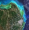
English: Cancún, situated in Quintana Roo on the northeast coast of Mexico’s Yucatán Peninsula, is featured in this image captured by the Copernicus Sentinel-2 mission.
Cancún’s location on the Caribbean Sea, tropical climate and string of beaches have made the city and the Riviera Maya to the south of Cancún one of Mexico’s top tourist destinations. In this image, captured on 16 April 2021, the city can be seen in the bottom-right corner, shrouded in clouds. Cancun International Airport, Mexico’s second busiest airport, is located around 20 km south of the city. The Cancún Island resort area, visible just off the coast, is shaped like the number seven and is around 22 km in length. The island is separated from the city by the Nichupté Lagoon but is linked by two causeways at each end. Most of the tourist industry is centred on Cancún Island with its Caribbean-facing beaches. Isla Mujeres, Spanish for ‘Island of Women,’ is visible just north of Cancún Island and is most famous for its beaches and snorkelling. Isla Contoy, visible in the top-right of the image, is considered one of the most important nesting places for sea birds in the Mexican Caribbean with more than 150 species of birds. Quintana Roo covers an area of around 42 000 sq km and is home to several protected areas including the El Eden Ecological Reserve, located 50 km northwest of Cancún, and Yum Balam Flora and Fauna Protected Area, located in the north of the state. Encompassing more than 150 000 hectares, Yum Balam is home to several endangered species including jaguars, crocodiles and monkeys. The colour of the water in the image varies from emerald green to turquoise owing to the changing water depths along the coast, turbidity and differences on the ocean floor – from sand to seaweed to rocky areas. With its 13 spectral channels, Copernicus Sentinel-2’s novel imager can capture water quality parameters such as the surface concentration of chlorophyll, detect harmful algal blooms, and measure turbidity (or water clarity) – giving a clear indication of the health and pollution levels. This image is also featured on the Earth from Space video programme. Credits: contains modified Copernicus Sentinel data (2021), processed by ESA, CC BY-SA 3.0 IGO |
| Fecha | |
| Fuente | https://www.flickr.com/photos/europeanspaceagency/51674516899/ |
| Autor | European Space Agency |
| Posición de la cámara | 21° 10′ 03,95″ N, 86° 55′ 06″ O | Ubicación de esta y otras imágenes en: OpenStreetMap |
|---|
Licencia
- Eres libre:
- de compartir – de copiar, distribuir y transmitir el trabajo
- de remezclar – de adaptar el trabajo
- Bajo las siguientes condiciones:
- atribución – Debes otorgar el crédito correspondiente, proporcionar un enlace a la licencia e indicar si realizaste algún cambio. Puedes hacerlo de cualquier manera razonable pero no de manera que sugiera que el licenciante te respalda a ti o al uso que hagas del trabajo.
- compartir igual – En caso de mezclar, transformar o modificar este trabajo, deberás distribuir el trabajo resultante bajo la misma licencia o una compatible como el original.
| Esta imagen fue publicada en Flickr por europeanspaceagency en https://flickr.com/photos/37472264@N04/51674516899. La imagen fue revisada el 12 de noviembre de 2021 por el robot FlickreviewR 2 y confirmó tener licencia bajo los términos de cc-by-sa-2.0. |
12 de noviembre de 2021
Leyendas
Elementos representados en este archivo
representa a
20 jul 2021
21°10'3.950"N, 86°55'6.002"W
image/jpeg
bdfabb6d1488f4af3a94334675840c85a70b2aec
42 861 895 byte
7675 píxel
7506 píxel
Historial del archivo
Haz clic sobre una fecha y hora para ver el archivo tal como apareció en ese momento.
| Fecha y hora | Miniatura | Dimensiones | Usuario | Comentario | |
|---|---|---|---|---|---|
| actual | 15:22 12 nov 2021 |  | 7506 × 7675 (40,88 MB) | Strakhov | Uploaded a work by European Space Agency from https://www.flickr.com/photos/europeanspaceagency/51674516899/ with UploadWizard |
Usos del archivo
La siguiente página usa este archivo:
Metadatos
Este archivo contiene información adicional, probablemente añadida por la cámara digital o el escáner usado para crearlo o digitalizarlo.
Si el archivo ha sido modificado desde su estado original, pueden haberse perdido algunos detalles.
| Orientación | Normal |
|---|---|
| Resolución horizontal | 72 ppp |
| Resolución vertical | 72 ppp |
| Software usado | Adobe Photoshop 22.5 (Windows) |
| Fecha y hora de modificación del archivo | 10:31 23 sep 2021 |
| Posicionamientos Y y C | Centrado |
| Versión de Exif | 2.32 |
| Fecha y hora de la digitalización | 14:37 20 jul 2021 |
| Significado de cada componente |
|
| Versión admitida de Flashpix | 1 |
| Espacio de color | Sin calibrar |
| Bits por componente |
|
| Esquema de compresión | Sin comprimir |
| Altura | 7675 px |
| Anchura | 7506 px |
| Composición de pixel | RGB |
| Número de componentes | 3 |
| Fecha en la cual fueron modificados por última vez los metadatos | 12:31 23 sep 2021 |
| Id. único del documento original | xmp.did:a8dfbb07-25e3-f142-93d5-eca75bffecc8 |
