
Archivo:BorahPeakID.jpg
Tamaño de esta previsualización: 800 × 441 píxeles. Otras resoluciones: 320 × 176 píxeles · 640 × 353 píxeles.
Ver la imagen en su resolución original (1089 × 600 píxeles; tamaño de archivo: 125 kB; tipo MIME: image/jpeg)
Resumen
| Descripción |
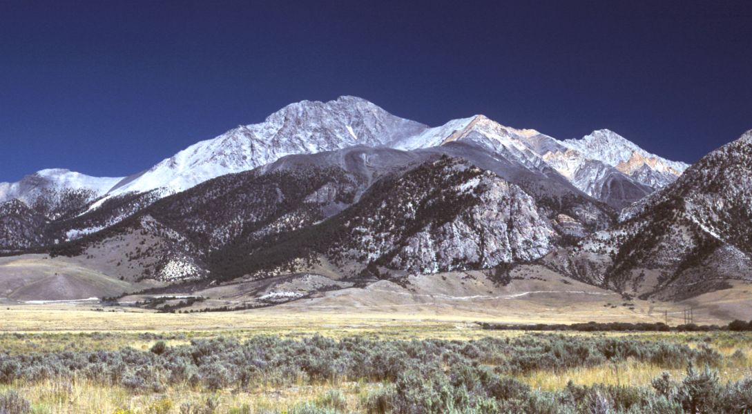
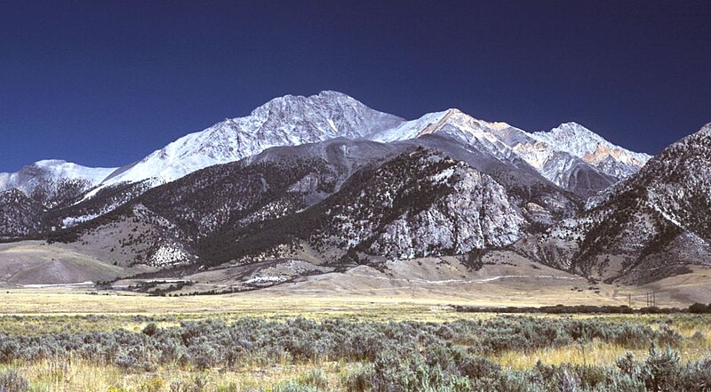
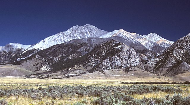
English: Borah Peak, Idaho, looking east. The normal climbing route begins in the wooded canyon at center left. The white line running along the base of the peak is the fault trace from the 1983 earthquake. |
| Fecha | 6 de mayo de 2006 (fecha original de carga) |
| Fuente | Transferido desde en.wikipedia a Commons por RedWolf usando CommonsHelper. |
| Autor | G. Thomas de Wikipedia en inglés |
Licencia
| Este trabajo ha sido liberado al dominio público por su autor, G. Thomas de Wikipedia en inglés. Esto aplica para todo el mundo. En algunos países esto puede no ser legalmente factible; si ello ocurriese: G. Thomas otorga a cualquier persona el derecho de usar este trabajo para cualquier propósito, sin ningún tipo de condición, a menos que éstas sean requeridas por la ley. |
Registro original de carga
Aquí se muestra la página de descripción original. Los siguientes nombres de usuario se refieren a en.wikipedia.
- 2006-05-06 20:17 G. Thomas 1089×600× (127941 bytes) Borah Peak, Idaho, looking east. The normal climbing route begins in the wooded canyon at center left. The white line running along the base of the peak is the fault trace from the 1983 earthquake.
Historial del archivo
Haz clic sobre una fecha y hora para ver el archivo tal como apareció en ese momento.
| Fecha y hora | Miniatura | Dimensiones | Usuario | Comentario | |
|---|---|---|---|---|---|
| actual | 16:15 21 feb 2009 | | 1089 × 600 (125 kB) | RedWolf | {{Information |Description={{en|Borah Peak, Idaho, looking east. The normal climbing route begins in the wooded canyon at center left. The white line running along the base of the peak is the fault trace from the 1983 earthquake.}} |Source=Transferred f |
Usos del archivo
Las siguientes páginas usan este archivo:
Uso global del archivo
Las wikis siguientes utilizan este archivo:
- Uso en bg.wikipedia.org
- Uso en cs.wikipedia.org
- Uso en en.wikipedia.org
- List of mountains of the United States
- Borah Peak
- List of U.S. states and territories by elevation
- Lost River Range
- List of the most isolated major summits of the United States
- List of ultras of North America
- List of the most prominent summits of the United States
- List of the major 100-kilometer summits of North America
- Mountain states
- List of the highest major summits of North America
- List of the major 3000-meter summits of the Rocky Mountains
- List of the highest major summits of the United States
- Uso en it.wikipedia.org
- Uso en it.wikivoyage.org
- Uso en nl.wikipedia.org
- Uso en pt.wikipedia.org
- Uso en ru.wikipedia.org
- Uso en simple.wikipedia.org
- Uso en uk.wikipedia.org