
Archivo:Aerial view of an Oyster Reef (22819976251).jpg

Tamaño de esta previsualización: 800 × 533 píxeles. Otras resoluciones: 320 × 213 píxeles · 640 × 427 píxeles · 1024 × 683 píxeles · 1280 × 853 píxeles · 2560 × 1707 píxeles · 4428 × 2952 píxeles.
Ver la imagen en su resolución original (4428 × 2952 píxeles; tamaño de archivo: 10,98 MB; tipo MIME: image/jpeg)
.jpg?uselang=es)
Resumen
| Descripción |
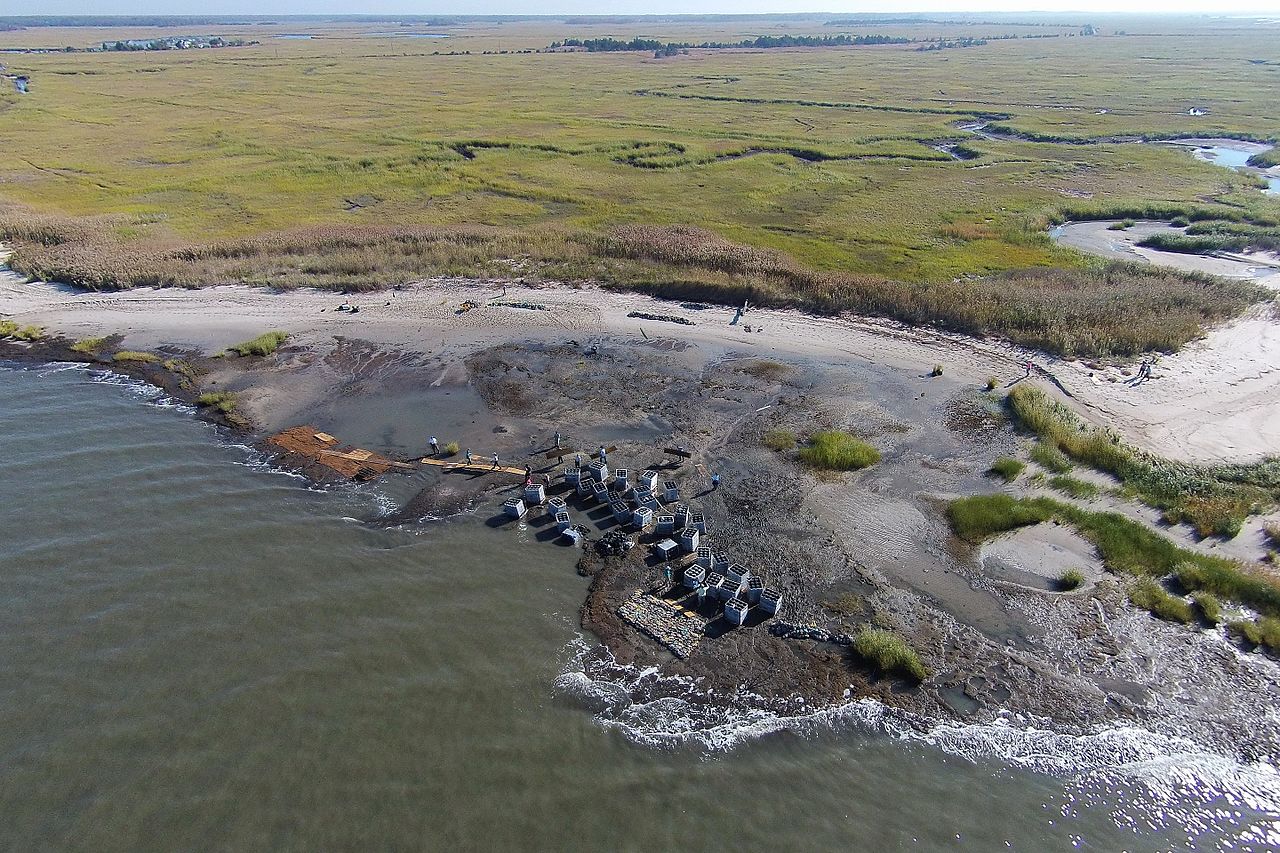
English: The first phase of the Hurricane Sandy-funded living shoreline installation in Downe Township, New Jersey, part of the Gandy’s Beach shoreline protection project, was completed in October 2015. For three days, partners and local volunteers placed a combination of “oyster castles” -- stackable, interlocking blocks of concrete, limestone, crushed shell and silica that encourage oyster larvae to settle -- and bagged oyster shells created by local schools, just offshore. Partner organizations will monitor the integrity of the structure through winter and apply findings to inform future reef installations in the same area next year. The work of this partnership will help stabilize approximately 3,000 feet of beach and tidal marsh shoreline, allowing the coast to heal itself.
|
| Fecha | |
| Fuente | https://www.flickr.com/photos/usfwsnortheast/22819976251/ |
| Autor | U. S. Fish and Wildlife Service - Northeast Region |
| Permiso (Reutilización de este archivo) |
At the time of upload, the image license was automatically confirmed using the Flickr API. For more information see Flickr API detail. |
| Flickr sets |
|
| Flickr tags |
|
| Posición de la cámara | | Ubicación de esta y otras imágenes en: OpenStreetMap |
|---|
.jpg¶ms=039.278611_N_-075.243612_E_globe:Earth_type:camera__&language=es)
Licencia
Este archivo está disponible bajo la licencia Creative Commons Atribución 2.0 Genérica.
- Eres libre:
- de compartir – de copiar, distribuir y transmitir el trabajo
- de remezclar – de adaptar el trabajo
- Bajo las siguientes condiciones:
- atribución – Debes otorgar el crédito correspondiente, proporcionar un enlace a la licencia e indicar si realizaste algún cambio. Puedes hacerlo de cualquier manera razonable pero no de manera que sugiera que el licenciante te respalda a ti o al uso que hagas del trabajo.
| Esta imagen fue publicada en Flickr por U. S. Fish and Wildlife Service - Northeast Region en https://flickr.com/photos/43322816@N08/22819976251. La imagen fue revisada el 28 de septiembre de 2016 por el robot FlickreviewR y confirmó tener licencia bajo los términos de cc-by-2.0. |
Esta imagen o grabación es obra de los empleados del Servicio de Pesca y Vida Silvestre de los Estados Unidos, recibidas o hechas durante el desempeño de sus funciones oficiales. Como obra del gobierno federal de los Estados Unidos de América, la imagen está en el dominio público. Para más información consulte la política de derechos de autor de Servicio de Pesca y Vida Silvestre.
|
 |
Historial del archivo
Haz clic sobre una fecha y hora para ver el archivo tal como apareció en ese momento.
| Fecha y hora | Miniatura | Dimensiones | Usuario | Comentario | |
|---|---|---|---|---|---|
| actual | 13:22 28 sep 2016 | | 4428 × 2952 (10,98 MB) | Fæ | Flickr Set 72157644908524104, ID 22819976251, Original title Aerial view of an Oyster Reef |
Usos del archivo
La siguiente página usa este archivo:
Uso global del archivo
Las wikis siguientes utilizan este archivo:
- Uso en cy.wikipedia.org
- Uso en ht.wikipedia.org
- Uso en ky.wikipedia.org
- Uso en uk.wikipedia.org
- Uso en www.wikidata.org
.jpg)