
Archivo:US Secession map 1863 (BlankMap derived).png

Tamaño de esta previsualización: 800 × 488 píxeles. Otras resoluciones: 320 × 195 píxeles · 640 × 390 píxeles · 841 × 513 píxeles.
Ver la imagen en su resolución original (841 × 513 píxeles; tamaño de archivo: 24 kB; tipo MIME: image/png)
.png?uselang=es)

|
Esta imagen debería volverse a crear como imágenes vectoriales SVG. Esto proporciona muchas ventajas, véase Commons:Media for cleanup (en inglés) para más información. Si ya hay una versión SVG de esta imagen disponible, por favor súbala a Commons. Tras subirla, reemplace esta plantilla con la plantilla
{{vector version available|nuevo nombre de imagen.svg}} en esta imagen. |
Resumen
| Descripción |
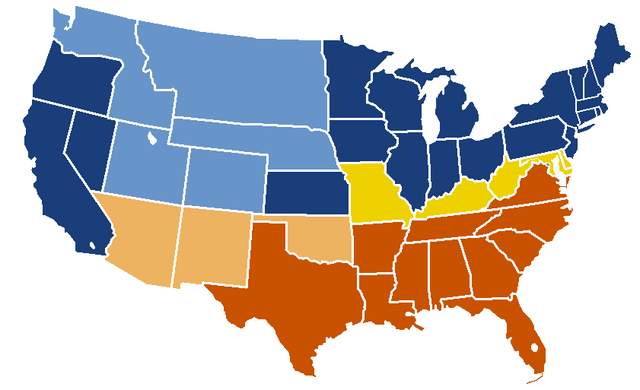
English: United States map of 1863, show affiliation of states and territories regarding the Secession War (Civil War.) Legend:
Union states Union territories not permitting slavery Border Union states, permitting slavery Confederate states Union territories permitting slavery (claimed by Confederacy) |
| Fecha | fecha original de carga: 19:04, 24 February 2007 |
| Fuente |
|
| Autor | w:en:Porsche997SBS (discusión | contribs.) |
Licencia
This map was obtained from an edition of the National Atlas of the United States. Like almost all works of the U.S. federal government, works from the National Atlas are in the public domain in the United States.
Online access: NationalAtlas.gov | 1970 print edition: Library of Congress, Perry-Castañeda Library
|
Registro original de carga
| date/time | username | resolution | size | edit summary |
|---|---|---|---|---|
| 19:04, 24 February 2007 | w:en:User:Porsche997SBS | 841×513 | 24 KB | trimming blankness |
| 18:59, 24 February 2007 | w:en:User:Porsche997SBS | 841×580 | 25 KB | don't need that |
| 18:55, 24 February 2007 | w:en:User:Porsche997SBS | 841×580 | 29 KB | format based on [http://en.wikipedia.org/wiki/Image:BlankMap-USA-states.PNG this image]; information from [http://en.wikipedia.org/wiki/Image:US_Secession_map_1865.svg this image]; see description pages there |
Image description page history
| link | date/time | username | edit summary |
|---|---|---|---|
| http://en.wikipedia.org/w/index.php?title=Image:US_Secession_map_1865_(BlankMap_derived).PNG&redirect=no&oldid=110635613 | 07:40, 10 September 2007 | w:en:User:Dmcdevit | |
| http://en.wikipedia.org/w/index.php?title=Image:US_Secession_map_1865_(BlankMap_derived).PNG&redirect=no&oldid=110635613 | 19:02, 24 February 2007 | w:en:User:Porsche997SBS | |
| http://en.wikipedia.org/w/index.php?title=Image:US_Secession_map_1865_(BlankMap_derived).PNG&redirect=no&oldid=110634272 | 18:55, 24 February 2007 | w:en:User:Porsche997SBS | (format based on [http://en.wikipedia.org/wiki/Image:BlankMap-USA-states.PNG this image]; information from [http://en.wikipedia.org/wiki/Image:US_Secession_map_1865.svg this image]; see description pages there) |
.PNG&redirect=no&oldid=110635613)
.PNG&redirect=no&oldid=110634272)
Historial del archivo
Haz clic sobre una fecha y hora para ver el archivo tal como apareció en ese momento.
| Fecha y hora | Miniatura | Dimensiones | Usuario | Comentario | |
|---|---|---|---|---|---|
| actual | 21:08 14 ene 2010 | | 841 × 513 (24 kB) | Porsche997SBS | Reverted to version as of 09:03, 14 January 2010--so frustrating |
| 21:07 14 ene 2010 |  | 841 × 513 (12 kB) | Porsche997SBS | let's try again | |
| 09:03 14 ene 2010 |  | 841 × 513 (24 kB) | Porsche997SBS | upload error? | |
| 08:52 14 ene 2010 |  | 841 × 513 (24 kB) | Porsche997SBS | fixing Nebraska, Dakota, and Washington territories and the border between Nevada and Utah | |
| 07:56 14 ene 2010 |  | 841 × 513 (24 kB) | Porsche997SBS | gray to blue | |
| 08:32 29 dic 2007 |  | 841 × 513 (24 kB) | Porsche997SBS | updating red to grey | |
| 16:45 13 sep 2007 |  | 841 × 513 (24 kB) | BetacommandBot | Transwiki approved by: w:en:User:Dmcdevit This image was copied from wikipedia:en. The original description was: format based on [http://en.wikipedia.org/wiki/Image:BlankMap-USA-states.PNG this image]; information from [http://en.wikipedia.org/wiki/ |
Usos del archivo
No hay páginas que enlacen a este archivo.
Uso global del archivo
Las wikis siguientes utilizan este archivo:
- Uso en anp.wikipedia.org
- Uso en ar.wikipedia.org
- Uso en azb.wikipedia.org
- Uso en cs.wikipedia.org
- Uso en eml.wikipedia.org
- Uso en en.wikipedia.org
- American Civil War
- History of the United States
- Origins of the American Civil War
- History of the United States (1849–1865)
- Turning point of the American Civil War
- User:Jimmuldrow/Sandbox
- Wikipedia:Graphics Lab/Map workshop/Archive/Jan 2012
- User:Themaster1112/sandbox
- User:2know4power/sandbox
- User:Falcaorib/Canada, United States and Mexico
- Uso en eo.wikipedia.org
- Uso en he.wikipedia.org
- Uso en hi.wikipedia.org
- Uso en hu.wikipedia.org
- Uso en hy.wikipedia.org
- Uso en ja.wikipedia.org
- Uso en kk.wikipedia.org
- Uso en kn.wikipedia.org
- Uso en ko.wikipedia.org
- Uso en la.wikipedia.org
- Uso en lt.wikipedia.org
- Uso en ml.wikipedia.org
- Uso en pt.wikipedia.org
- Uso en ru.wikipedia.org
- Uso en si.wikipedia.org
- Uso en sk.wikipedia.org
- Uso en th.wikipedia.org
- Uso en vi.wikipedia.org
.png)