
Archivo:The Map of Early Penang Showing the Malay Town on the South of the Town Center by Popham 1799 overlaid with OSM.png

Tamaño de esta previsualización: 619 × 599 píxeles. Otras resoluciones: 248 × 240 píxeles · 496 × 480 píxeles · 793 × 768 píxeles · 1057 × 1024 píxeles · 2024 × 1960 píxeles.
Ver la imagen en su resolución original (2024 × 1960 píxeles; tamaño de archivo: 593 kB; tipo MIME: image/png)
Resumen
| Descripción |
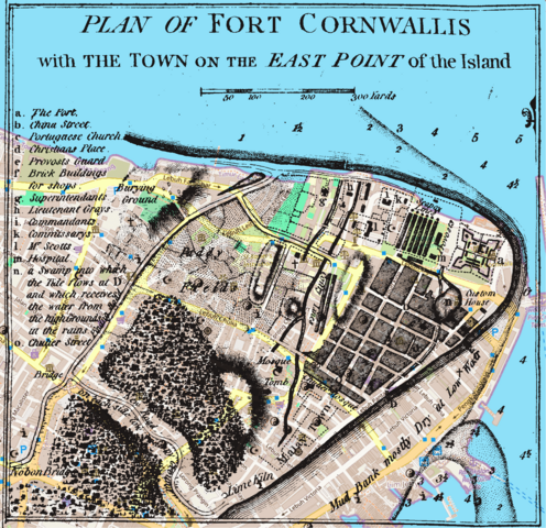
English: The Map of Early Penang Showing the Malay Town on the South of the Town Center by Popham 1799 overlaid with a modern map |
|
| Fecha | ||
| Fuente |
OpenStreetMap, and Popham, Home Riggs. Description of Prince of Wales Island in the Straits of Malacca with Its Advantages as a Marine Establishment. London.
|
|
| Autor | OpenStreetMap contributors, Sir Home Riggs Popham |

Licencia
Este archivo se encuentra bajo la licencia Creative Commons Genérica de Atribución/Compartir-Igual 2.0.
- Eres libre:
- de compartir – de copiar, distribuir y transmitir el trabajo
- de remezclar – de adaptar el trabajo
- Bajo las siguientes condiciones:
- atribución – Debes otorgar el crédito correspondiente, proporcionar un enlace a la licencia e indicar si realizaste algún cambio. Puedes hacerlo de cualquier manera razonable pero no de manera que sugiera que el licenciante te respalda a ti o al uso que hagas del trabajo.
- compartir igual – En caso de mezclar, transformar o modificar este trabajo, deberás distribuir el trabajo resultante bajo la misma licencia o una compatible como el original.
Historial del archivo
Haz clic sobre una fecha y hora para ver el archivo tal como apareció en ese momento.
| Fecha y hora | Miniatura | Dimensiones | Usuario | Comentario | |
|---|---|---|---|---|---|
| actual | 13:43 8 mar 2024 | | 2024 × 1960 (593 kB) | Cmglee | Uploaded a work by OpenStreetMap contributors, Sir Home Riggs Popham from OpenStreetMap, and Popham, Home Riggs. Description of Prince of Wales Island in the Straits of Malacca with Its Advantages as a Marine Establishment. London. with UploadWizard |
Usos del archivo
No hay páginas que enlacen a este archivo.
Uso global del archivo
Las wikis siguientes utilizan este archivo:
- Uso en en.wikipedia.org