
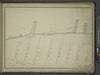
Archivo:Map bounded by Bulkhead and Pier Line 58-62, W. 19th St, 10th Avenue, W. 12th St; Including Thirteenth Avenue, 11th Ave, W. 12th St, W. 13th St, W. 14th St, W. 15th St, W. 16th St, W. 17th NYPL1648023 crop.tiff

Tamaño de esta previsualización JPG del archivo TIF: 800 × 464 píxeles. Otras resoluciones: 320 × 186 píxeles · 640 × 371 píxeles · 1024 × 594 píxeles · 1280 × 742 píxeles · 2560 × 1484 píxeles · 6252 × 3625 píxeles.
Ver la imagen en su resolución original (6252 × 3625 píxeles; tamaño de archivo: 26,82 MB; tipo MIME: image/tiff)
Resumen
| Descripción | [Map bounded by Bulkhead and Pier Line 58-62, W. 19th St, 10th Avenue, W. 12th St; Including Thirteenth Avenue, 11th Ave, W. 12th St, W. 13th St, W. 14th St, W. 15th St, W. 16th St, W. 17th St, W. 18th St]; Atlases of New York city. / Maps of the wharves and piers from the Battery to 61st street on the Hudson river and from the Battery to 41st street on the East river, New York. Surveyed by I.C. Buckhout, city surveyor. | |||||||||||||||||||||||
| Fecha | Fecha desconocida | |||||||||||||||||||||||
| Fuente |
http://digitalgallery.nypl.org/nypldigital/dgkeysearchdetail.cfm?imageID=1648023
|
|||||||||||||||||||||||
| Autor | cropped by Beyond My Ken (discusión) 00:49, 1 December 2015 (UTC) | |||||||||||||||||||||||
| Permiso (Reutilización de este archivo) |
From The Lionel Pincus and Princess Firyal Map Division. http://maps.nypl.org
|
|||||||||||||||||||||||
| Otras versiones | ||||||||||||||||||||||||
| Location | Stephen A. Schwarzman Building / The Lionel Pincus and Princess Firyal Map Division | |||||||||||||||||||||||
| Digital item published | 7-25-2008; updated 3-25-2011 | |||||||||||||||||||||||
| Digital ID | 1648023 | |||||||||||||||||||||||

Historial del archivo
Haz clic sobre una fecha y hora para ver el archivo tal como apareció en ese momento.
| Fecha y hora | Miniatura | Dimensiones | Usuario | Comentario | |
|---|---|---|---|---|---|
| actual | 00:49 1 dic 2015 | 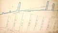 | 6252 × 3625 (26,82 MB) | Beyond My Ken | =={{int:filedesc}}== <!-- Mediawiki Template --> {{Information | author = cropped by ~~~~ | date = {{other date|unknown}} | description = [Map bounded by Bulkhead and Pier Line 58-62, W. 19th St, 10th Avenue, W. 12th St; Including Thirteenth Avenue... |
Usos del archivo
No hay páginas que enlacen a este archivo.
Uso global del archivo
Las wikis siguientes utilizan este archivo:
- Uso en en.wikipedia.org