
Archivo:Checkerboard forest in Idaho.jpg
Ver la imagen en su resolución original (4928 × 3280 píxeles; tamaño de archivo: 7,97 MB; tipo MIME: image/jpeg)
Resumen
| Descripción |
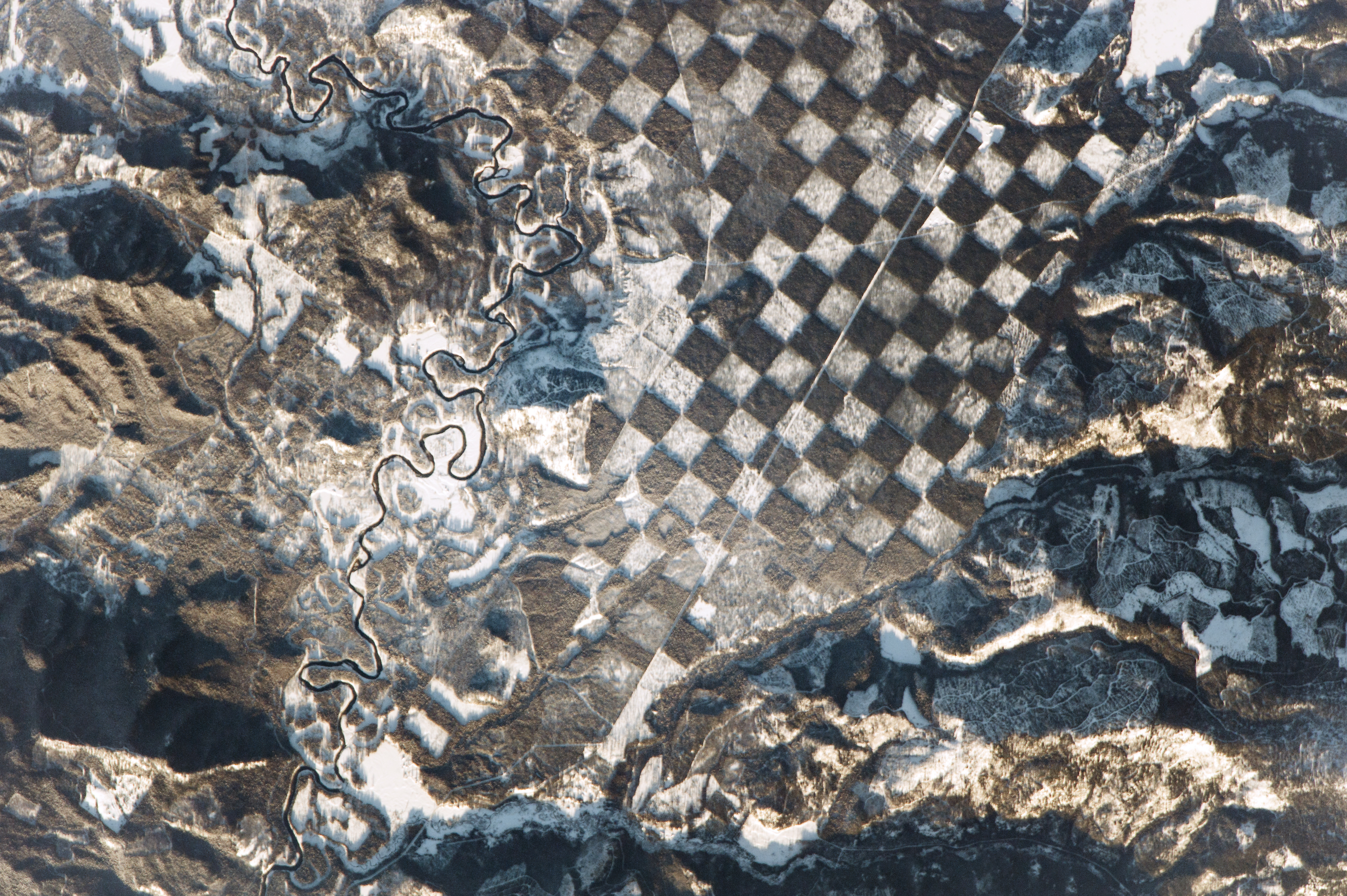
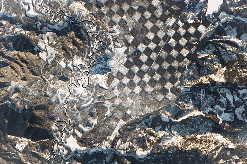
Afrikaans: ’n Ruimtevaarder aan boord van die Internasionale Ruimtestasie het hierdie opvallende skaakbordpatroon langs die Priestrivier in die noorde van Idaho waargeneem. Die foto is net voor sononder geneem, sodat sommige berghange gloei terwyl ander deur lang skaduwees bedek word weens die lae sonhoek.
Die kwartmylbreë (400 m) vierkante in hierdie landskapskaakbord blyk die resultaat van bosbestuur te wees. Soortgelyke patrone het in die 1800's ontstaan, toe alternatiewe lappies grond deur die Amerikaanse regering aan spoorweë soos die Noord-Pasifiese Spoorweg toegestaan is, en etlike lappies grond in die Pasifiese Noordweste verkoop en die hout geoes is. Die grond wat hier gewys word, word tans vir wild en bosbou aangewend. Die wit kolle weerspieël gebiede met jonger, kleiner bome, waar wintersneeubedekking helder vir die ruimtevaarders vertoon. Donker groenbruin blokkies is lappies van digter, ongeskonde woud. Die skaakbord-benadering handhaaf die volhoubaarheid van beboste streke, terwyl die oes van bome 'n opsie bly. Die Priestrivier, wat van bo na onder deur die toneel kronkel, word weerskante deur 'n woudbuffer begrens wat as 'n natuurlike filtrasiestelsel kan dien om waterkwaliteit te beskerm. Byna 'n eeu lank is die rivier benut om hout te vervoer. Dit het egter in 1968 verander toe die rivier se hoofstroom by 'n lys van "wilde en natuurskoon riviere" gevoeg is om vir hul "uitstaande natuurlike, kulturele en ontspanningsvoordele" in 'n natuurlik-funksionerende toestand vir die genot van huidige en toekomstige geslagte bewaar te word. Whitetail Butte (links op beeld) is histories deur staats- en federale grondbestuurders as 'n uitkykpunt vir bosbrande gebruik.English: An astronaut aboard the International Space Station observed this distinctive checkerboard pattern alongside the Priest River in northern Idaho. The photograph was taken just before sunset, so some mountainsides glow while others are covered in long shadows because of the low Sun angle.
The quarter-mile (400 m) squares in this landscape checkerboard appear to be the result of forest management. Similar patterns originated in the 1800s, when alternate parcels of land were granted by the U.S. government to railroads such as the Northern Pacific. Many parcels in the Pacific Northwest were later sold off and harvested for timber. The land shown here is now managed for wildlife and for timber harvesting. The white patches reflect areas with younger, smaller trees, where winter snow cover shows up brightly to the astronauts. Dark green-brown squares are parcels of denser, intact forest. The checkerboard is used as a method of maintaining the sustainability of forested tracts while still enabling a harvest of trees. The Priest River, winding through the scene from top to bottom, is bordered on both sides by a forest buffer that can serve as a natural filtration system to protect water quality. For nearly a century, the river was used to transport logs. Its function changed in 1968 when the river’s main stem was added to a list of “wild and scenic rivers” in order to preserve its “outstanding natural, cultural, and recreational values in a free-flowing condition for the enjoyment of present and future generations.” Whitetail Butte has historically been used by state and federal land managers as a lookout point for forest fires. |
| Fecha | |
| Fuente | http://earthobservatory.nasa.gov/IOTD/view.php?id=89541&eocn=image&eoci=moreiotd |
| Autor | "An astronaut aboard the International Space Station"—"a member of the Expedition 50 crew" |
| Posición de la cámara | | Ubicación de esta y otras imágenes en: OpenStreetMap |
|---|
Astronaut photograph ISS050-E-28519 was acquired on January 4, 2017, with a Nikon D4 digital camera using an 1150 millimeter lens, and is provided by the ISS Crew Earth Observations Facility and the Earth Science and Remote Sensing Unit, Johnson Space Center. The image was taken by a member of the Expedition 50 crew. The image has been cropped and enhanced to improve contrast, and lens artifacts have been removed. The International Space Station Program supports the laboratory as part of the ISS National Lab to help astronauts take pictures of Earth that will be of the greatest value to scientists and the public, and to make those images freely available on the Internet. Additional images taken by astronauts and cosmonauts can be viewed at the NASA/JSC Gateway to Astronaut Photography of Earth. Caption by Andi Hollier, Hx5, and M. Justin Wilkinson, Texas State University, Jacobs Contract at NASA-JSC. The photo's vantage point was outer space but relative to the surface of the earth, it is rotated approximately 20° clockwise.
Licencia
| Este archivo es de dominio público porque fue creado por la NASA. Las políticas sobre copyright de la NASA estipulan que «el material de la NASA no está protegido con copyright a menos que se indique lo contrario». (Políticas sobre copyright de la NASA o Políticas sobre la utilización de imágenes del Jet Propulsion Laboratory). | ||
 |
Advertencias:
|

|
Esta imagen ha sido evaluada según los criterios de imágenes valiosas y es considerada la imagen más preciada en Wikimedia Commons en el ámbito de aplicación: Forests in Idaho, checkerboard forest photographed from the International Space Station.. Para mayor información, puede ver su nominación en está página (en inglés): Commons:Valued image candidates/Checkerboard forest in Idaho.jpg. |
| Annotations | This image is annotated: View the annotations at Commons |
Historial del archivo
Haz clic sobre una fecha y hora para ver el archivo tal como apareció en ese momento.
| Fecha y hora | Miniatura | Dimensiones | Usuario | Comentario | |
|---|---|---|---|---|---|
| actual | 05:52 7 feb 2017 | | 4928 × 3280 (7,97 MB) | Koavf | {{Information |Description ={{en|1=An astronaut aboard the International Space Station observed this distinctive checkerboard pattern alongside the Priest River in northern Idaho. The photograph was taken just before sunset, so some mountainsides gl... |
Usos del archivo
No hay páginas que enlacen a este archivo.
Uso global del archivo
Las wikis siguientes utilizan este archivo:
- Uso en en.wikipedia.org
- Uso en hu.wikipedia.org