Ir al contenido

Archivo:Zalzala Jazeera 2013 Gwadar.jpg

Contenido de la página no disponible en otros idiomas.
De Wikipedia, la enciclopedia libre

Zalzala_Jazeera_2013_Gwadar.jpg (720 × 480 píxeles; tamaño de archivo: 94 kB; tipo MIME: image/jpeg)

Resumen

Descripción
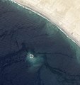
English: Zalzala Jazeera (Earthquake Island) appears near the center of this image of the bay west of Gwadar, Pakistan.

On September 26, 2013, the Advanced Land Imager (ALI) on NASA’s Earth Observing-1 (EO-1) satellite captured the top image of that new island, which sits roughly one kilometer (0.6 miles) offshore. Likely a “mud volcano,” the island rose from the seafloor near Gwadar on September 24, shortly after the earthquake struck about 380 kilometers (230 miles) inland. File:Gwadar satellite view.jpg, acquired by the Operational Land Imager on the Landsat 8 satellite, shows the same area on April 17, 2013.

In the satellite images, lighter shades of green and tan in the water reveal shallow seafloor or suspended sediment. The water depth around the new island is roughly 15 to 20 meters, according to marine geologist Asif Inam of Pakistan’s National Institute of Oceanography. “The floor in that area is generally flat, but the gradient in this area changes quite abruptly,” Inam said. The top image from ALI is also clear enough to show the parallel ripples of waves marching toward the shore.
Fecha
Fuente http://earthobservatory.nasa.gov/NaturalHazards/view.php?id=82146
Autor NASA
Otras versiones
Posición de la cámara25° 10′ 46,56″ N, 62° 13′ 50,52″ E Kartographer map based on OpenStreetMap.Ubicación de esta y otras imágenes en: OpenStreetMapinfo

Licencia

Public domain Este archivo es de dominio público porque fue creado por la NASA. Las políticas sobre copyright de la NASA estipulan que «el material de la NASA no está protegido con copyright a menos que se indique lo contrario». (Políticas sobre copyright de la NASA o Políticas sobre la utilización de imágenes del Jet Propulsion Laboratory).
Advertencias:
  • El uso del logotipo de la NASA (incluidos el logotipo actual y los anteriores) está restringido.
  • El sitio web de la NASA almacena una gran cantidad de imágenes del Programa Espacial de la URSS, de la Agencia Espacial Federal Rusa y otras agencias espaciales no estadounidenses. Estas imágenes no son de dominio público.
  • Material del Telescopio espacial Hubble puede tener copyright si no proviene explícitamente del Space Telescope Science Institute. [1]
  • Todo el material creado por la sonda espacial SOHO está protegido por copyright y requiere permiso para ser utilizado con fines comerciales o no educativos. [2]
  • Las imágenes que figuran en el sitio web Astronomy Picture of the Day (APOD) pueden tener copyright. [3]

Leyendas

Añade una explicación corta acerca de lo que representa este archivo

Elementos representados en este archivo

representa a

25°10'46.6"N, 62°13'50.5"E

Historial del archivo

Haz clic sobre una fecha y hora para ver el archivo tal como apareció en ese momento.

Fecha y horaMiniaturaDimensionesUsuarioComentario
actual01:33 28 sep 2013Miniatura de la versión del 01:33 28 sep 2013720 × 480 (94 kB)Rehmanofficial nasa crop
01:18 28 sep 2013Miniatura de la versión del 01:18 28 sep 2013459 × 486 (30 kB)Ke4rohUser created page with UploadWizard

La siguiente página usa este archivo:

Uso global del archivo

Las wikis siguientes utilizan este archivo:

Metadatos