
Archivo:Yazoo river.gif

Tamaño de esta previsualización: 477 × 599 píxeles. Otras resoluciones: 191 × 240 píxeles · 382 × 480 píxeles · 776 × 975 píxeles.
Ver la imagen en su resolución original (776 × 975 píxeles; tamaño de archivo: 46 kB; tipo MIME: image/gif)
| Descripción |
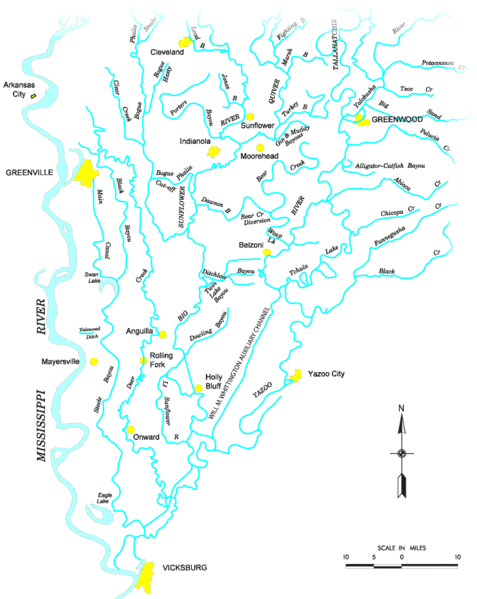
Map of the Yazoo River watershed — located in Mississippi.
|
|||
| Fuente |
http://www.mvk.usace.army.mil/offices/pp/projects/yazoobackwater/docs/01app4.pdf[dead link] |
|||
| Autor | ||||
| Permiso (Reutilización de este archivo) |
|
Historial del archivo
Haz clic sobre una fecha y hora para ver el archivo tal como apareció en ese momento.
| Fecha y hora | Miniatura | Dimensiones | Usuario | Comentario | |
|---|---|---|---|---|---|
| actual | 19:19 19 nov 2006 | | 776 × 975 (46 kB) | PhilFree | Yazoo River, USA. The image uploaded is modified from the original created by U. S. Army Corps of Engineers' Vicksburg District ([http://www.mvk.usace.army.mil/offices/pp/projects/yazoobackwater/docs/01app4.pdf Yazoo Backwater Reformulation Report (pdf)]) |
Usos del archivo
La siguiente página usa este archivo:
Uso global del archivo
Las wikis siguientes utilizan este archivo:
- Uso en ar.wikipedia.org
- Uso en cs.wikipedia.org
- Uso en da.wikipedia.org
- Uso en de.wikipedia.org
- Uso en en.wikipedia.org
- Uso en fr.wikipedia.org
- Uso en fy.wikipedia.org
- Uso en it.wikipedia.org
- Uso en pl.wikipedia.org
- Uso en sv.wikipedia.org
- Uso en www.wikidata.org