Archivo:Wpdms usgs photo sacramento delta 2.jpg

Contenido de la página no disponible en otros idiomas.
De Wikipedia, la enciclopedia libre

Wpdms_usgs_photo_sacramento_delta_2.jpg(700 × 520 píxeles; tamaño de archivo: 81 kB; tipo MIME: image/jpeg)

Descripción

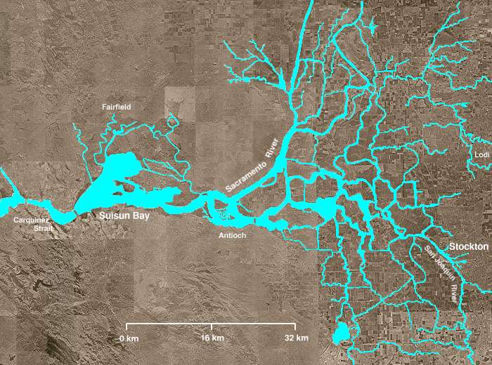
The Sacramento-San Joaquin River Delta of California - covering the right half of the map.

  • The Sacramento River flows into the delta from the north and the San Joaquin River from the south. The San Joaquin and Sacramento rivers meet just west of Antioch and their confluence continues westward into Suisun Bay and then the Carquinez Strait (both on left of map).
  • The Mokelumne River enters from the east, flows northwest from Lodi, picks up several tributaries including the Cosumnes River, then turns south, meandering among several delta sloughs and waterways, ultimately flowing into the San Joaquin River in the center of the delta, northeast of Antioch.
  • The "lake-like" body of water near the bottom of the image is Clifton Court Forebay, where pumps lift water to be sent southward in the California Water Project canal.
  • Several other open areas in the right half of the image are "islands," many of which have elevations well below sea level. Waterways (in blue) are clearly visible, as are fields and croplands (which appear as patchwork), and urban areas (especially Stockton).
Fecha
Fuente http://en.wikipedia.org/wiki/Image:Wpdms_usgs_photo_sacramento_delta_2.jpg
Autor Matthew Trump
Permiso
(Reutilización de este archivo)
English Wikipedia user Decumanus, titular de los derechos de autor de esta obra, la publica en los términos de la siguiente licencia:
GNU head Se autoriza la copia, distribución y modificación de este documento bajo los términos de la licencia de documentación libre GNU, versión 1.2 o cualquier otra que posteriormente publique la Fundación para el Software Libre; sin secciones invariables, textos de portada, ni textos de contraportada. Se incluye una copia de la dicha licencia en la sección titulada Licencia de Documentación Libre GNU.
w:es:Creative Commons
atribución compartir igual
Este archivo se encuentra bajo la licencia Creative Commons Genérica de Atribución/Compartir-Igual 3.0.
Atribución: English Wikipedia user Decumanus
Eres libre:
  • de compartir – de copiar, distribuir y transmitir el trabajo
  • de remezclar – de adaptar el trabajo
Bajo las siguientes condiciones:
  • atribución – Debes otorgar el crédito correspondiente, proporcionar un enlace a la licencia e indicar si realizaste algún cambio. Puedes hacerlo de cualquier manera razonable pero no de manera que sugiera que el licenciante te respalda a ti o al uso que hagas del trabajo.
  • compartir igual – En caso de mezclar, transformar o modificar este trabajo, deberás distribuir el trabajo resultante bajo la misma licencia o una compatible como el original.
Esta etiqueta de licencia fue agregada a este archivo como parte de la actualización de la licencia GFDL.
Otras versiones Obras derivadas de ésta:  California Grizzly Bear walking in the Delta Region.jpg

en:Sacramento-San Joaquin River Delta

Leyendas

Añade una explicación corta acerca de lo que representa este archivo
The Sacramento-San Joaquin River Delta of California

Elementos representados en este archivo

representa a

Historial del archivo

Haz clic sobre una fecha y hora para ver el archivo tal como apareció en ese momento.

Fecha y horaMiniaturaDimensionesUsuarioComentario
actual03:21 8 ago 2008Miniatura de la versión del 03:21 8 ago 2008700 × 520 (81 kB)Captndelta{{Information |Description=The Sacramento-San Joaquin River Delta covers the right half of this image. The Sacramento River flows into the delta from the north and the San Joaquin River from the south. The Mokelumne River

La siguiente página usa este archivo:

Uso global del archivo

Metadatos