
Archivo:Volcan-de-Fuego-v2.jpg
Ver la imagen en su resolución original (5288 × 3000 píxeles; tamaño de archivo: 3,39 MB; tipo MIME: image/jpeg)
Resumen
| Descripción |
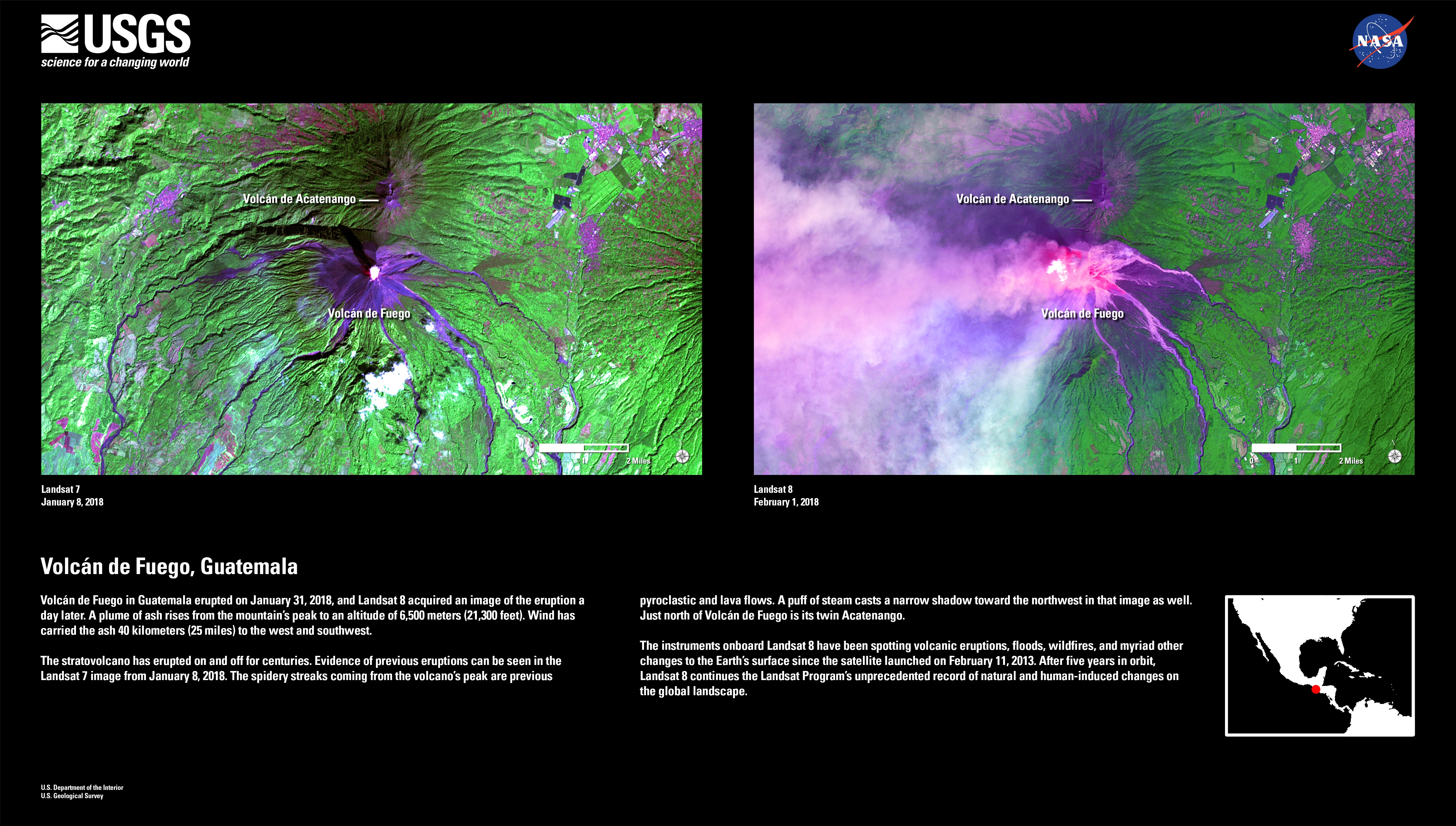
English: Volcán de Fuego in Guatemala erupted on January 31, 2018, and Landsat 8 acquired an image of the eruption a day later. A plume of ash rises from the mountain’s peak to an altitude of 6,500 meters (21,300 feet). Wind has carried the ash 40 kilometers (25 miles) to the west and southwest.
The stratovolcano has erupted on and off for centuries. Evidence of previous eruptions can be seen in the Landsat 7 image from January 8, 2018. The spidery streaks coming from the volcano’s peak are previous pyroclastic and lava flows. A puff of steam casts a narrow shadow toward the northwest in that image as well. Just north of Volcán de Fuego is its twin Acatenango. The instruments onboard Landsat 8 have been spotting volcanic eruptions, floods, wildfires, and myriad other changes to the Earth’s surface since the satellite launched on February 11, 2013. After five years in orbit, Landsat 8 continues the Landsat Program’s unprecedented record of natural and human-induced changes on the global landscape. |
| Fecha | |
| Fuente |
Volcán de Fuego in Guatemala erupted on January 31, 2018, and Landsat 8 acquired an image of the eruption a day later. A plume of ash rises from the mountain’s peak to an altitude of 6,500 meters (21,300 feet). Wind has carried the ash 40 kilometers (25 miles) to the west and southwest. The stratovolcano has erupted on and off for centuries. Evidence of previous eruptions can be seen in the Landsat 7 image from January 8, 2018. The spidery streaks coming from the volcano’s peak are previous pyroclastic and lava flows. A puff of steam casts a narrow shadow toward the northwest in that image as well. Just north of Volcán de Fuego is its twin Acatenango. The instruments onboard Landsat 8 have been spotting volcanic eruptions, floods, wildfires, and myriad other changes to the Earth’s surface since the satellite launched on February 11, 2013. After five years in orbit, Landsat 8 continues the Landsat Program’s unprecedented record of natural and human-induced changes on the global landscape. |
| Autor | U.S. Department of the Interior | U.S. Geological Survey |
Licencia
Esta imagen está en el dominio público, ya que contiene materiales que originalmente vinieron del Servicio Geológico de los Estados Unidos de América, una agencia del Departamento del Interior. Para obtener más información, consulte la política oficial de derechos de los USGS.
|
Historial del archivo
Haz clic sobre una fecha y hora para ver el archivo tal como apareció en ese momento.
| Fecha y hora | Miniatura | Dimensiones | Usuario | Comentario | |
|---|---|---|---|---|---|
| actual | 10:50 6 jun 2018 | | 5288 × 3000 (3,39 MB) | LuisArmandoRasteletti | User created page with UploadWizard |
Usos del archivo
La siguiente página usa este archivo:
Uso global del archivo
Las wikis siguientes utilizan este archivo:
- Uso en ast.wikipedia.org
- Uso en ro.wikipedia.org