
Archivo:Tornado in southwestern Oklahoma on November 7, 2011.jpg
Tamaño de esta previsualización: 800 × 521 píxeles. Otras resoluciones: 320 × 208 píxeles · 640 × 417 píxeles · 1024 × 667 píxeles · 1280 × 833 píxeles · 3144 × 2047 píxeles.
Ver la imagen en su resolución original (3144 × 2047 píxeles; tamaño de archivo: 2 MB; tipo MIME: image/jpeg)
Resumen
| Descripción |
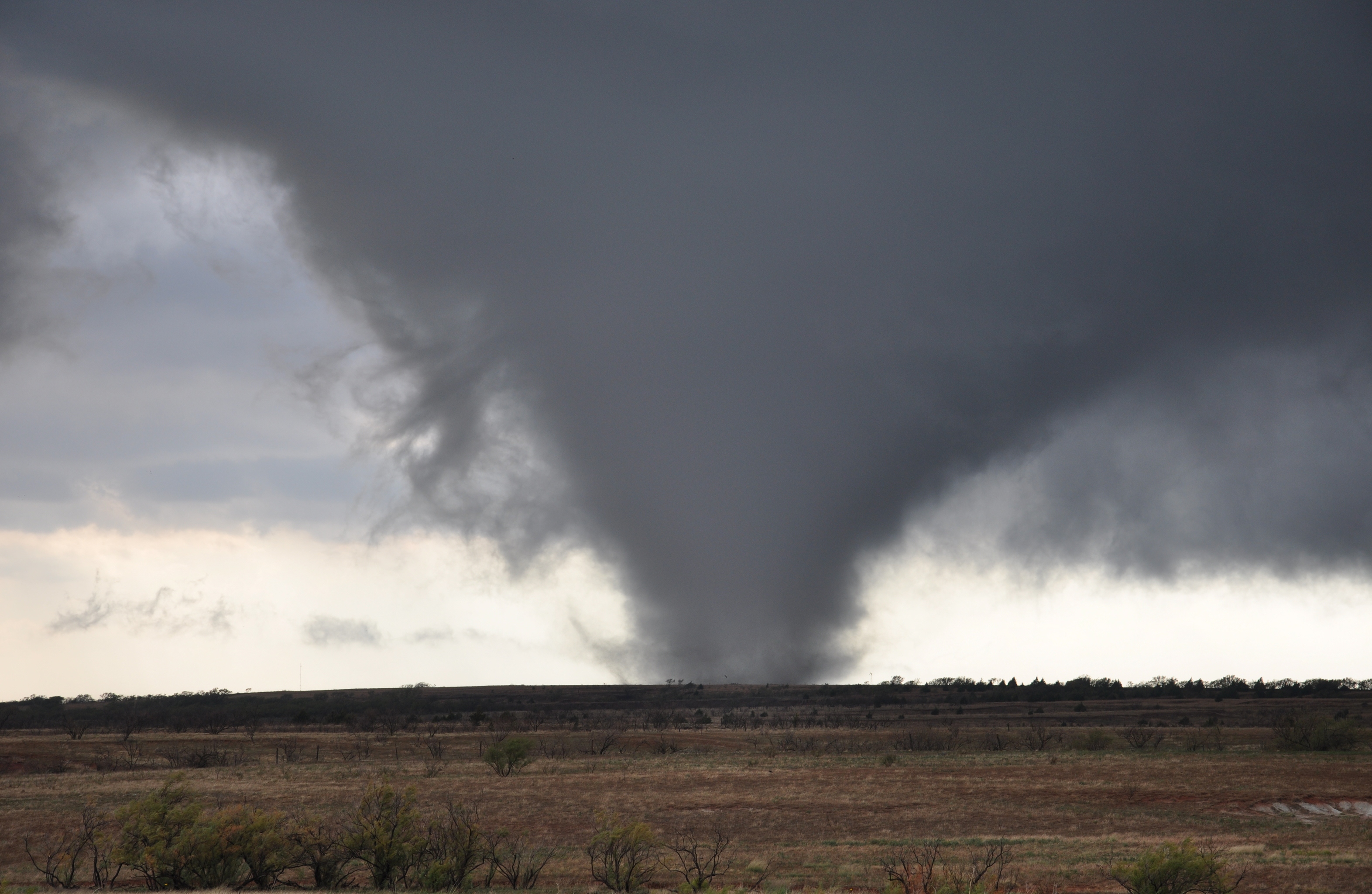
English: A tornado in Oklahoma on November 7, 2011, and the second of nine to form in Oklahoma that day. The tornado formed around 21:15 UTC (15:15 local time) and moved towards the northeast northwest of the town of Manitou. As of November 18 the tornado has not yet been rated. Coordinates below are approximate based upon this map. |
| Fecha | |
| Fuente | http://www.srh.noaa.gov/images/oun/wxevents/20111107/Chris_Spannagle_Manitou2.jpg |
| Autor | Chris Spannagle |
| Ubicación del objeto | | Ubicación de esta y otras imágenes en: OpenStreetMap |
|---|
Licencia

|
La información que atribuye al autor como su nombre, el correo electrónico, la página web o su firma, que anteriormente fue visible en la imagen en sí ha sido trasladada en los metadatos y/o la página de descripción en el archivo. Esto hace que la imagen sea más fácil de reutilizar y tenga un lenguaje más neutro, haciendo que la búsquedas por texto resulte más fácil de procesar. Commons garantiza visualizar la información del autor al usar en las imágenes.
|
This image is in the public domain because it was stored on the web servers of the U.S. National Weather Service. NWS-created images are automatically public domain in the U.S. since the NWS is a part of the U.S. government. However, the NWS sites also host non-NWS images which have been submitted by individuals: these are generally shown as "Courtesy of ...". Such images have explicitly been released to the public domain by the copyright owner as part of the upload process.
As stated at https://www.weather.gov/fsd/disclaimer: "By submitting images, you understand that your image is being released into the public domain. This means that your photo or video may be downloaded, copied, and used by others." Thus, all* images on NWS servers are public domain (including "Courtesy of ..." and “Photo by ...” images) unless specifically stated otherwise through a copyright (©) watermark.
*A deletion discussion in November 2023 ruled that Getty Images on the web servers of NWS, are to be considered copyrighted, even without a copyright (©) watermark and are the sole exception to this rule.
|
Historial del archivo
Haz clic sobre una fecha y hora para ver el archivo tal como apareció en ese momento.
| Fecha y hora | Miniatura | Dimensiones | Usuario | Comentario | |
|---|---|---|---|---|---|
| actual | 22:38 10 nov 2011 | | 3144 × 2047 (2 MB) | Ks0stm | {{Information |Description ={{en|1=A tornado near Manitou, Oklahoma on November 7, 2011.}} |Source =http://www.srh.noaa.gov/images/oun/wxevents/20111107/Chris_Spannagle_Manitou2.jpg |Author =Chris Spannagle |Date =2011-11-07 | |
Usos del archivo
La siguiente página usa este archivo:
Uso global del archivo
Las wikis siguientes utilizan este archivo:
- Uso en en.wikipedia.org
- Uso en he.wikipedia.org
- Uso en io.wiktionary.org
- Uso en pt.wikinews.org
- Uso en simple.wikipedia.org
- Uso en sv.wikipedia.org