
Archivo:Tokyo Metropolitan Expressway map.svg

Ver la imagen en su resolución original ((Imagen SVG, nominalmente 6048 × 8688 pixels, tamaño de archivo: 584 kB))
See the talk page for a larger legible image (1024 px).
- Other Versions

| Este trabajo ha sido liberado al dominio público por su autor, SPUI. Esto aplica para todo el mundo. En algunos países esto puede no ser legalmente factible; si ello ocurriese: |
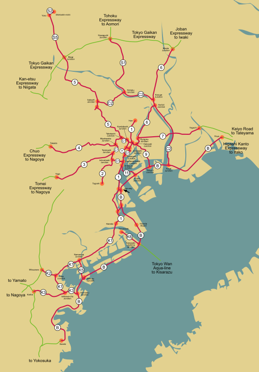
Map of the Tokyo Metropolitan Expressway network (red) and connecting expressways (green).
| # | Name (jp) | Name (en) | Description | Connections |
|---|---|---|---|---|
| 環状線 (belt highways) | ||||
| C1 | 高速都心環状線 | Inner Circular* | 環状線部分 (full belt) | |
| C2 | 高速中央環状線 | Central Circular | 西新宿JCT (Nishi-Shinjuku Junction) to 葛西JCT (Kasai Junction) | |
| 放射線 (radial highways) | ||||
| 1 | 高速1号上野線 | Ueno* | 江戸橋JCT (Edobashi Junction) to 入谷 (Iriya) | |
| 1 | 高速1号羽田線 | Haneda* | 浜崎橋JCT (Hamazaki-bashi Junction) to 羽田 (Haneda) | |
| 2 | 高速2号目黒線 | Meguro | 一ノ橋JCT (Ichinohashi Junction) to 戸越 (Togoshi) | |
| 3 | 高速3号渋谷線 | Shibuya* | 谷町JCT (Tanimachi Junction) to 用賀 (Yoga) | 東名高速道路 (Tomei Expressway) |
| 4 | 高速4号新宿線 | Shinjuku* | 三宅坂JCT (Miyakezaka Junction) to 高井戸 (Takaido) | 中央自動車道 (Chuo Expressway) |
| 5 | 高速5号池袋線 | Ikebukuro* | 竹橋JCT (Takebashi Junction) to 美女木JCT (Bijogi Junction) | |
| 6 | 高速6号向島線 | Mukojima* | 江戸橋JCT (Edobashi Junction) to 堀切JCT (Horikiri Junction) | |
| 6 | 高速6号三郷線 | Misato* | 小菅JCT (Kosuge Junction) to 三郷JCT (Misato Junction) | 常磐自動車道 (Joban Expressway) |
| 7 | 高速7号小松川線 | Komatsugawa | 両国JCT (Ryogoku Junction) to 谷河内 (Yagochi) | 京葉道路 (Keiyo Road) |
| 9 | 高速9号深川線 | Fukagawa* | 箱崎JCT (Hakozaki Junction) to 辰巳JCT (Tatsumi Junction) | |
| 10 | 高速10号晴海線 | Harumi* | 晴海 (Harumi) to 東雲JCT (Shinonome Junction) | |
| 11 | 高速11号台場線 | Daiba* | 芝浦JCT (Shibaura Junction) to 有明JCT (Ariake Junction) | |
| S1 | 高速川口線 | Kawaguchi* | 江北JCT (Kohoku Junction) to 川口JCT (Kawaguchi Junction) | 東北自動車道 (Tohoku Expressway) |
| その他の路線 (other routes) | ||||
| Y | 高速八重洲線 | Yaesu | 神田橋JCT (Kandabashi Junction) to 汐留JCT (Shiodome Junction) plus a branch from 西銀座JCT to 京橋JCT | |
| B | 高速湾岸線 | Bayshore* | 川崎浮島JCT (Kawasaki-ukishima Junction) to 高谷 (Koya) | 東関東自動車道 (Higashi Kanto Expressway) |
| - | 高速湾岸分岐線 | Bayshore branch | 昭和島JCT to 東海JCT | |
| 神奈川線 (Kanagawa routes) | ||||
| K1 | 高速神奈川1号横羽線 | Yokohane* | 羽田 (Haneda) to 石川町JCT (Ishikawa-cho Junction) | |
| K2 | 高速神奈川2号三ツ沢線 | Mitsusawa | 金港JCT (Kinko Junction) to 三ツ沢 (Mitsuzawa) | unknown expressway |
| K3 | 高速神奈川3号狩場線 | Kariba | 本牧JCT (Honmoku Junction) to 狩場 (Kariba) | unknown expressway |
| K5 | 高速神奈川5号大黒線 | Daikoku | 生麦JCT (Namamugi Junction) to 大黒JCT (Daikoku Junction) | |
| K6 | 高速神奈川6号川崎線 | Kawasaki | 殿町 (Tonomachi) to 川崎浮島JCT (Kawasaki-ukishima Junction) | 東京湾アクアライン (Tokyo Wan Aqua-line) |
| B | 高速湾岸線 | Bayshore* | 並木 (Namiki) to 川崎浮島JCT (Kawasaki-ukishima Junction) | unknown expressway |
| 埼玉線 (Saitama routes) | ||||
| S2 | 高速埼玉新都心線 | Saitama Shintoshin | 与野 (Yono) to 新都心 (Shintoshin-nishi) | |
| S5 | 高速埼玉大宮線 | Omiya | 美女木JCT (Bijogi Junction) to 与野 (Yono) | |
An asterisk is used for English names listed on the official website. "Route" or "Line" sometimes appears after.
There are also connections to the 東京外環自動車道 (Tokyo Gaikan Expressway/Tokyo Outer Ring Road) and thus to the 関越自動車道 (Kan-etsu Expressway).
Main sources are [1] and [2]. Traced on Google Maps (mainly aerial photos). The aerial photo in the background is from Landsat and is thus public domain, specifically this image.
Historial del archivo
Haz clic sobre una fecha y hora para ver el archivo tal como apareció en ese momento.
| Fecha y hora | Miniatura | Dimensiones | Usuario | Comentario | |
|---|---|---|---|---|---|
| actual | 23:49 30 abr 2010 | | 6048 × 8688 (584 kB) | DieBuche | removed raster image. pure svg. |
| 04:33 12 feb 2006 |  | 6048 × 8688 (1,03 MB) | SPUI~commonswiki | fixed the one-way | |
| 22:02 10 feb 2006 |  | 6074 × 8679 (1,05 MB) | SPUI~commonswiki | time to upload it yo |
Usos del archivo
La siguiente página usa este archivo:
Uso global del archivo
Las wikis siguientes utilizan este archivo:
- Uso en de.wikipedia.org
- Uso en en.wikivoyage.org
- Uso en pl.wikipedia.org
- Uso en www.wikidata.org