
Archivo:Thistlelandslideusgs.jpg
No se dispone de una resolución más alta.
Thistlelandslideusgs.jpg (800 × 543 píxeles; tamaño de archivo: 150 kB; tipo MIME: image/jpeg)
Resumen
| Descripción |
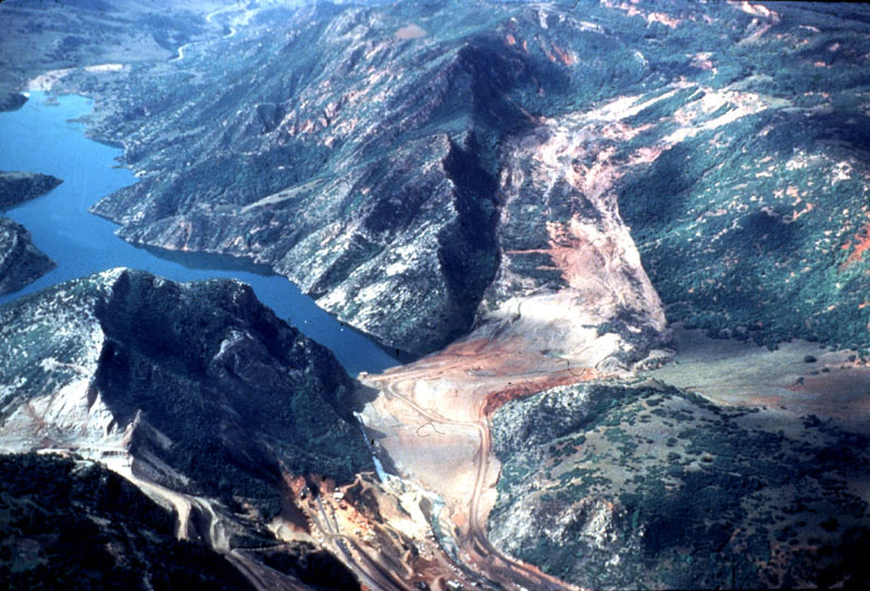
English: The lake that formed from a landslide that dammed the Spanish Fork River and destroyed the town of Thistle. The massive cut visible in the left is construction to relocate US-6 which was inundated by the landslide. |
| Fecha | |
| Fuente | http://landslides.usgs.gov/learning/imagepreviews.php |
| Autor | R.L. Schuster, U.S. Geological Survey |
Licencia
Esta imagen está en el dominio público, ya que contiene materiales que originalmente vinieron del Servicio Geológico de los Estados Unidos de América, una agencia del Departamento del Interior. Para obtener más información, consulte la política oficial de derechos de los USGS.
|
This file was reviewed on 22 de septiembre de 2010 by the administrator or trusted user Jappalang (talk), who confirmed the Public Domain status on that date.
|
Historial del archivo
Haz clic sobre una fecha y hora para ver el archivo tal como apareció en ese momento.
| Fecha y hora | Miniatura | Dimensiones | Usuario | Comentario | |
|---|---|---|---|---|---|
| actual | 02:10 14 mar 2010 | | 800 × 543 (150 kB) | Moabdave | {{Information |Description={{en|1=The Lake that formed from a landslide that dammed the Spanish Fork River and destroyed the town of Thistle, Utah, the massive cut visible in the left is construction to relocate US-6 which was inundated by the landsli |
Usos del archivo
La siguiente página usa este archivo:
Uso global del archivo
Las wikis siguientes utilizan este archivo:
- Uso en arz.wikipedia.org
- Uso en en.wikipedia.org
- Uso en ja.wikipedia.org
- Uso en pt.wikipedia.org
- Uso en ru.wikipedia.org
- Uso en www.wikidata.org