
Archivo:Survey of Palestine, Maps of Palestine 08-Land-Classification (FL147392109 2367029).jpg

Tamaño de esta previsualización: 332 × 598 píxeles. Otras resoluciones: 133 × 240 píxeles · 266 × 480 píxeles · 426 × 768 píxeles · 568 × 1024 píxeles · 1136 × 2048 píxeles · 6383 × 11 501 píxeles.
Ver la imagen en su resolución original (6383 × 11 501 píxeles; tamaño de archivo: 73,78 MB; tipo MIME: image/jpeg)
Resumen
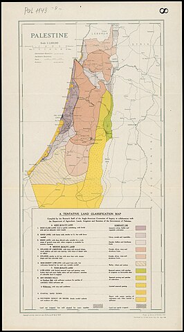
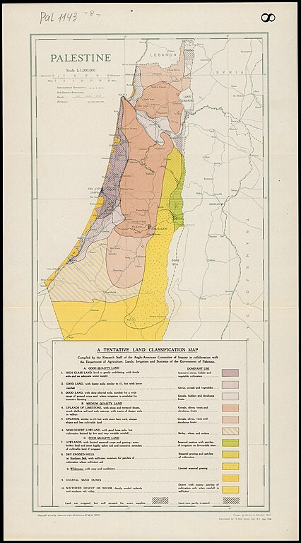
| Survey of Palestine: Maps of Palestine
( |
||||||||||||||||||||||||
|---|---|---|---|---|---|---|---|---|---|---|---|---|---|---|---|---|---|---|---|---|---|---|---|---|
| Artista |
|
|||||||||||||||||||||||
| Título |
Maps of Palestine |
|||||||||||||||||||||||
| Descripción |
Maps of Palestine. Prepared for the information of The United Nations Special Committee of Enquiry. |
|||||||||||||||||||||||
| Idioma | inglés | |||||||||||||||||||||||
| Fecha de publicación | junio de 1947 | |||||||||||||||||||||||
| Colección |
|
|||||||||||||||||||||||
| Ubicación actual |
|
|||||||||||||||||||||||
| Notas | 9 maps (1. Near and Middle East; 2. Relief; 3. Rainfall; 4. Climatic Elements; 5. Population, December 1944; 6. Administrative Divisions; 7. Land Settlement 1947; 8. Land Classification; 9. Land in Jewish Possession and Zones...) | |||||||||||||||||||||||
| escala | 1:4,000,000 cm | |||||||||||||||||||||||
| IE PID | IE147392094 | |||||||||||||||||||||||
| Rosetta nombre de archivo | FL147392109 | |||||||||||||||||||||||
| identificador NNL de obra (P3959) | 990023670290205171 | |||||||||||||||||||||||
| search Merhav catalog | inglés, Survey of Palestine | |||||||||||||||||||||||
| Fuente/fotógrafo |
|
|||||||||||||||||||||||
| Otras versiones | ||||||||||||||||||||||||
| Jpg / Tif version |
|
|||||||||||||||||||||||

.jpg)

.jpg?uselang=es)
Licencia
Esta obra creada por el Gobierno del Reino Unido está en el dominio público porque se cumple una de las siguientes:
HMSO declaró que la expiración de los derechos de autor de la Corona se aplica en todo el mundo (ref: HMSO Email Reply)
|
 |
This work was created or ordered by the State of Israel, and is in the public domain because it satisfies one of the conditions stipulated in Israel's copyright statute from 2007 (translation) regarding the State's copyrights:
|

|
[[Category:]]
Historial del archivo
Haz clic sobre una fecha y hora para ver el archivo tal como apareció en ese momento.
| Fecha y hora | Miniatura | Dimensiones | Usuario | Comentario | |
|---|---|---|---|---|---|
| actual | 16:12 12 ago 2023 | | 6383 × 11 501 (73,78 MB) | Geagea | pattypan 22.03 |
Usos del archivo
La siguiente página usa este archivo:
Uso global del archivo
Las wikis siguientes utilizan este archivo:
- Uso en ar.wikipedia.org
- Uso en en.wikipedia.org
.jpg)