
Archivo:Suez Canal traffic jam seen from space.jpg
Ver la imagen en su resolución original (1920 × 1141 píxeles; tamaño de archivo: 1,8 MB; tipo MIME: image/jpeg)
Resumen
| Descripción |
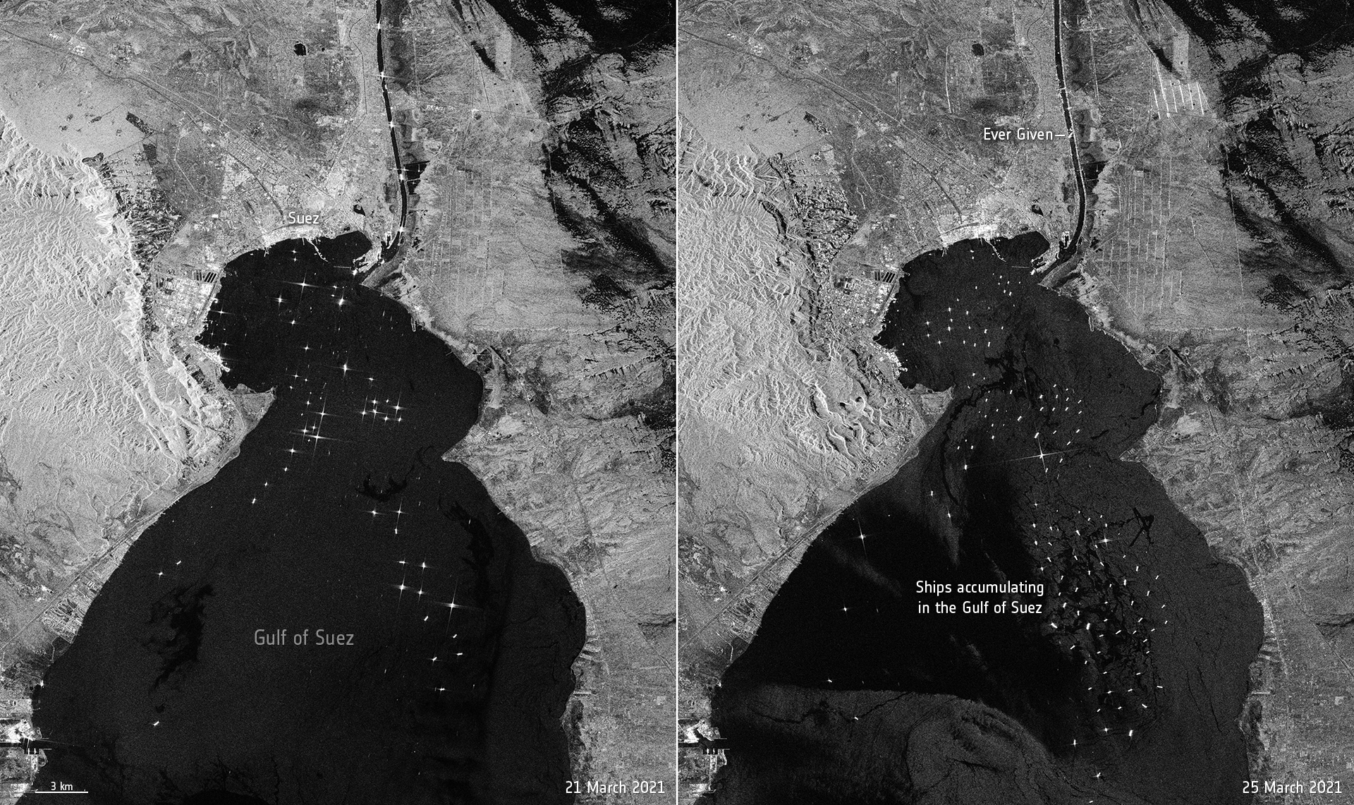
Español: Bloqueo del Canal de Suez causado por el barco Ever Given visto por el satélite Sentinel-1.
English: The enormous Ever Given container ship, wedged in Egypt’s Suez Canal, is visible in new images captured by the Copernicus Sentinel-1 mission.
The giant container ship ran aground in the canal on 23 March on its journey from China to the Netherlands. The image on the left, captured on 21 March, shows routine maritime traffic in the canal with vessels visible every 2 to 3 km. The image on the right, captured on 25 March, shows the 400 m-ship blocking the canal. The canal connects Port Said on the Mediterranean Sea to the Indian Ocean via the Egyptian city of Suez on the Red Sea. The blockage has delayed hundreds of tankers and vessels in reaching their destination, and more maritime traffic is still heading to the crucial waterway. Ships can be seen accumulating in the Gulf of Suez. Tug boats are working hard to dislodge the 200 000 tonne ship, however Egyptian authorities say it is unclear when the route will reopen. The two identical Copernicus Sentinel-1 satellites carry radar instruments to provide an all-weather, day-and-night supply of imagery of Earth’s surface, making it ideal to monitor ship traffic. The sea surface reflects the radar signal away from the satellite, and makes water appear dark in the image. This contrasts with metal objects, in this case the ships in the bay, which appear as bright dots in the dark waters. |
| Fecha | |
| Fuente | https://www.esa.int/ESA_Multimedia/Images/2021/03/Suez_Canal_traffic_jam_seen_from_space |
| Autor | European Space Agency |
Licencia

|
Esta imagen contiene datos que provienen de un satélite del Programa Copérnico, como Sentinel-1, Sentinel 2 o Sentinel-3. Se require atribución cuando se utilice esta imagen.
Atribución: Contiene datos modificados de Copernicus Sentinel 2021
El uso de datos Sentinel del Programa Cópernico está regulado por la legislación europea: Reglamento Delegado (UE) No 1159/2013 de la Comisión y el Reglamento (UE) No 377/2014. Los pasajes relevantes son:
Se permitirá el acceso gratuito a los datos dedicados del GMES y a la información de servicio del GMES a través de las plataformas de difusión del GMES [...].
Se dará acceso a los datos dedicados del GMES y a la información de servicio del GMES a los efectos que se detallan a continuación, siempre y cuando sean lícitos:
Los datos dedicados del GMES y la información de servicio del GMES podrán utilizarse en todo el mundo sin limitación de tiempo.
Los datos dedicados del GMES y la información de servicio del GMES se facilitarán a los usuarios sin ninguna garantía explícita o implícita, incluyendo lo tocante a la calidad y la idoneidad para cualesquiera fines. |
This media was created by the European Space Agency (ESA).
Where expressly so stated, images or videos are covered by the Creative Commons Attribution-ShareAlike 3.0 IGO (CC BY-SA 3.0 IGO) licence, ESA being an Intergovernmental Organisation (IGO), as defined by the CC BY-SA 3.0 IGO licence. The user is allowed under the terms and conditions of the CC BY-SA 3.0 IGO license to Reproduce, Distribute and Publicly Perform the ESA images and videos released under CC BY-SA 3.0 IGO licence and the Adaptations thereof, without further explicit permission being necessary, for as long as the user complies with the conditions and restrictions set forth in the CC BY-SA 3.0 IGO licence, these including that:
See the ESA Creative Commons copyright notice for complete information, and this article for additional details.
|
 | |
Este archivo se encuentra bajo la licencia Creative Commons Atribución Compartir-Igual 3.0 IGO. Atribución: ESA, CC BY-SA IGO 3.0
| ||
Historial del archivo
Haz clic sobre una fecha y hora para ver el archivo tal como apareció en ese momento.
| Fecha y hora | Miniatura | Dimensiones | Usuario | Comentario | |
|---|---|---|---|---|---|
| actual | 14:37 26 mar 2021 | | 1920 × 1141 (1,8 MB) | BugWarp | Uploaded a work by European Space Agency from https://www.esa.int/ESA_Multimedia/Images/2021/03/Suez_Canal_traffic_jam_seen_from_space with UploadWizard |
Usos del archivo
La siguiente página usa este archivo:
Uso global del archivo
Las wikis siguientes utilizan este archivo:
- Uso en ar.wikipedia.org
- Uso en ca.wikipedia.org
- Uso en eu.wikipedia.org
- Uso en fa.wikipedia.org
- Uso en fr.wikipedia.org
- Uso en he.wikipedia.org
- Uso en it.wikipedia.org
- Uso en ja.wikipedia.org
- Uso en ko.wikipedia.org
- Uso en pl.wikipedia.org
- Uso en ru.wikipedia.org
- Uso en simple.wikipedia.org
- Uso en sv.wikipedia.org
- Uso en ta.wikipedia.org
- Uso en tr.wikipedia.org
- Uso en uk.wikipedia.org
- Uso en vi.wikipedia.org
- Uso en www.wikidata.org
- Uso en zh.wikipedia.org