
Archivo:Robin Hood Gardens, Cotton Street - geograph.org.uk - 1517514.jpg
No se dispone de una resolución más alta.
Robin_Hood_Gardens,_Cotton_Street_-_geograph.org.uk_-_1517514.jpg (640 × 480 píxeles; tamaño de archivo: 142 kB; tipo MIME: image/jpeg)
Resumen
| Descripción |
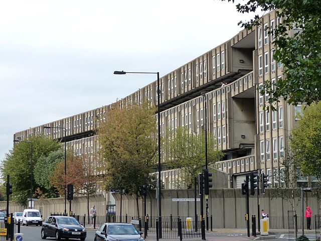
English: Robin Hood Gardens, Cotton Street The west side of the west block. Robin Hood Gardens is one of London's most notorious 1960s housing estates which is loathed by some but revered by others as a beacon of modern architecture. There are probably more people in the former camp than the latter. There are two blocks aligned roughly north-south with a patch of green space between them. They were designed by Alison and Peter Smithson in 1966-72, with Christopher Woodward and Ken Baker of the Greater London Council. The buildings embody the Smithsons' idea of "streets in the sky" and are an example of concrete Brutalism, with the pre-cast concrete being rough and shuttered. Pevsner comments that while being "impressively monumental" the scheme is also "inhumane" because of the high density, the narrowness of the decks and its proximity to busy roads on two sides.
Tower Hamlets Council plan to demolish the buildings and redevelop the site. A campaign by the Twentieth Century Society and others to halt this by applying for listed building status in 2008 was unsuccessful. |
| Fecha | |
| Fuente | From geograph.org.uk |
| Autor | Stephen Richards |
| Atribución (requerido por la licencia) | Stephen Richards / Robin Hood Gardens, Cotton Street (1) / |
| Posición de la cámara | | Ubicación de esta y otras imágenes en: OpenStreetMap |
|---|
_heading:22.00&language=es)
| Ubicación del objeto | | Ubicación de esta y otras imágenes en: OpenStreetMap |
|---|
_heading:22.00&language=es)
Licencia

|
Esta imagen proviene de la colección del proyecto Geograph British Isles. Veáse la página de esta fotografía en el sitio web de Geograph para más información del fotógrafo. El titular de los derechos de autor de esta imagen es Stephen Richards y autoriza utilizarla bajo la licencia Reconocimiento-CompartirIgual 2.0 de Creative Commons.
|
Este archivo se encuentra bajo la licencia Creative Commons Genérica de Atribución/Compartir-Igual 2.0.
Atribución: Stephen Richards
- Eres libre:
- de compartir – de copiar, distribuir y transmitir el trabajo
- de remezclar – de adaptar el trabajo
- Bajo las siguientes condiciones:
- atribución – Debes otorgar el crédito correspondiente, proporcionar un enlace a la licencia e indicar si realizaste algún cambio. Puedes hacerlo de cualquier manera razonable pero no de manera que sugiera que el licenciante te respalda a ti o al uso que hagas del trabajo.
- compartir igual – En caso de mezclar, transformar o modificar este trabajo, deberás distribuir el trabajo resultante bajo la misma licencia o una compatible como el original.
Historial del archivo
Haz clic sobre una fecha y hora para ver el archivo tal como apareció en ese momento.
| Fecha y hora | Miniatura | Dimensiones | Usuario | Comentario | |
|---|---|---|---|---|---|
| actual | 00:53 3 mar 2011 | | 640 × 480 (142 kB) | GeographBot | == {{int:filedesc}} == {{Information |description={{en|1=Robin Hood Gardens, Cotton Street The west side of the west block. Robin Hood Gardens is one of London's most notorious 1960s housing estates which is loathed by some but revered by others as a beac |
Usos del archivo
La siguiente página usa este archivo:
Uso global del archivo
Las wikis siguientes utilizan este archivo:
- Uso en en.wikipedia.org
- Uso en it.wikipedia.org