
Archivo:PIA02740 lrg.jpg

Ver la imagen en su resolución original (2220 × 994 píxeles; tamaño de archivo: 778 kB; tipo MIME: image/jpeg)
URL: http://visibleearth.nasa.gov/view_rec.php?id=2265
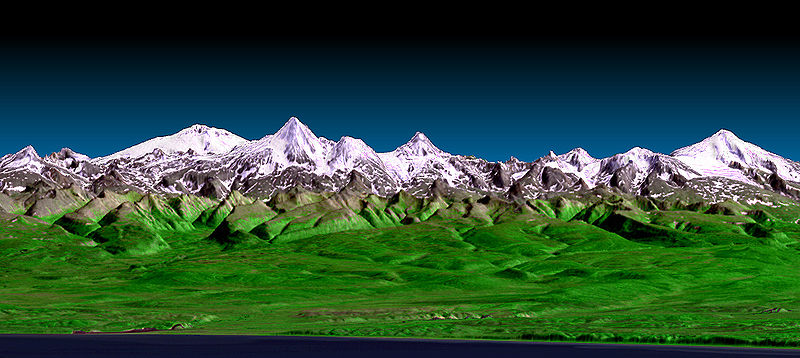
Credit:Image Courtesy SRTM, NASA/JPL/NIMA
This perspective view shows the western side of the volcanically active Kamchatka Peninsula in eastern Russia. The image was generated using the first data collected during the Shuttle Radar Topography Mission (SRTM). In the foreground is the Sea of Okhotsk. Inland from the coast, vegetated floodplains and low relief hills rise toward snow-capped peaks. The topographic effects on snow and vegetation distribution are very clear in this near-horizontal view. Forming the skyline is the Sredinnyy Khrebet, the volcanic mountain range that makes up the spine of the peninsula. High resolution SRTM topographic data will be used by geologists to study how volcanoes form, and to understand the hazards posed by future eruptions.
This image was generated using topographic data from SRTM and an enhanced true-color image from the Landsat 7 satellite. This image contains about 2,400 meters (7,880 feet) of total relief. The topographic expression was enhanced by adding artificial shading as calculated from the SRTM elevation model. The Landsat data was provided by the United States Geological Survey’s Earth Resources Observations Systems (EROS) Data Center, Sioux Falls, South Dakota.
Size: 33.3 km (20.6 miles) wide x 136 km (84 miles) coast to skyline Location: 58.3 deg. North lat., 160 deg. East long. Orientation: Easterly view, 2 degrees down from horizontal Original Data Resolution: 30 meters (99 feet) Vertical Exaggeration: 3 times Date Acquired: February 12, 2000 (SRTM) August 1, 1999 (Landsat) Image: NASA/JPL/NIMA
| Este archivo es de dominio público porque fue creado por la NASA. Las políticas sobre copyright de la NASA estipulan que «el material de la NASA no está protegido con copyright a menos que se indique lo contrario». (Políticas sobre copyright de la NASA o Políticas sobre la utilización de imágenes del Jet Propulsion Laboratory). | ||
 |
Advertencias:
|
Historial del archivo
Haz clic sobre una fecha y hora para ver el archivo tal como apareció en ese momento.
| Fecha y hora | Miniatura | Dimensiones | Usuario | Comentario | |
|---|---|---|---|---|---|
| actual | 20:45 25 ago 2005 | | 2220 × 994 (778 kB) | Nanosmile | Credit:Image Courtesy SRTM, NASA/JPL/NIMA This perspective view shows the western side of the volcanically active Kamchatka Peninsula in eastern Russia. The image was generated using the first data collected during the Shuttle Radar Topography Mission (S |
Usos del archivo
La siguiente página usa este archivo:
Uso global del archivo
Las wikis siguientes utilizan este archivo:
- Uso en en.wikipedia.org
- Uso en et.wikipedia.org