
Archivo:Orchard Park Municipal Center, Orchard Park, New York - 20201206.jpg

Tamaño de esta previsualización: 800 × 480 píxeles. Otras resoluciones: 320 × 192 píxeles · 1024 × 614 píxeles · 1280 × 768 píxeles · 2560 × 1536 píxeles · 4032 × 2419 píxeles.
Ver la imagen en su resolución original (4032 × 2419 píxeles; tamaño de archivo: 3,06 MB; tipo MIME: image/jpeg)
Resumen
| Descripción |
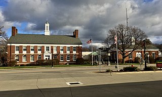
English: The Orchard Park Municipal Center, 4295 South Buffalo Street, Orchard Park, New York, December 2020. Respectively, the two wings of the building house the town and village offices (left) and the police department (right) and were built in 1949 as separate structures; an expansion in 1990 (center) served to connect the two and also added additional space in the rear. The original portions of the building, designed by the firm of Hudson & Hudson, exemplify the Colonial Revival style of architecture, which at that time retained a great deal of popularity in designs for government, school, and other institutional buildings, even as it had already passed out of favor in the arena of residential architecture. Both of the designs include classic Colonial hallmarks such as symmetrical façades and side-gabled roofs each with a central copper-topped cupola, but they differ from each other in the fine details. The more elaborate town hall portion sports a pedimented entrance, ornamental twin chimneys on the side elevations adjacent to the peak of the roof, and a contrast between the windows on the ground floor (round-arched and topped consecutively with fanlights and decorative keystones) and the second floor (rectangular and topped with stone lintels), with stone belt courses delineating the boundaries between floors. Meanwhile, the single-story and more modestly designed police station has a segmental-arched entrance with a golden eagle adorning the tympanum. |
| Fecha | Tomada el 6 de diciembre de 2020, 13:59:50 |
| Fuente | Trabajo propio |
| Autor | Andre Carrotflower |
| Posición de la cámara | | Ubicación de esta y otras imágenes en: OpenStreetMap |
|---|
Licencia
Yo, el titular de los derechos de autor de esta obra, la publico en los términos de la siguiente licencia:
Este archivo está disponible bajo la licencia Creative Commons Attribution-Share Alike 4.0 International.
- Eres libre:
- de compartir – de copiar, distribuir y transmitir el trabajo
- de remezclar – de adaptar el trabajo
- Bajo las siguientes condiciones:
- atribución – Debes otorgar el crédito correspondiente, proporcionar un enlace a la licencia e indicar si realizaste algún cambio. Puedes hacerlo de cualquier manera razonable pero no de manera que sugiera que el licenciante te respalda a ti o al uso que hagas del trabajo.
- compartir igual – En caso de mezclar, transformar o modificar este trabajo, deberás distribuir el trabajo resultante bajo la misma licencia o una compatible como el original.
Historial del archivo
Haz clic sobre una fecha y hora para ver el archivo tal como apareció en ese momento.
| Fecha y hora | Miniatura | Dimensiones | Usuario | Comentario | |
|---|---|---|---|---|---|
| actual | 00:43 14 ene 2021 | | 4032 × 2419 (3,06 MB) | Andre Carrotflower | Uploaded own work with UploadWizard |
Usos del archivo
La siguiente página usa este archivo:
Uso global del archivo
Las wikis siguientes utilizan este archivo:
- Uso en ar.wikipedia.org
- Uso en ca.wikipedia.org
- Uso en fr.wikipedia.org
- Uso en pl.wikipedia.org
- Uso en uk.wikipedia.org
- Uso en www.wikidata.org