
Archivo:Official LanguagesMap-Africa.png
No se dispone de una resolución más alta.
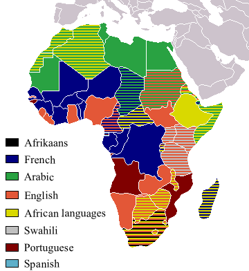
Official_LanguagesMap-Africa.png (360 × 392 píxeles; tamaño de archivo: 21 kB; tipo MIME: image/png)

|
File:Official LanguagesMap-Africa.svg es una versión vectorial de este archivo. Debería usarse esa versión en lugar de este archivo PNG, cuando sea mejor.
File:Official LanguagesMap-Africa.png → File:Official LanguagesMap-Africa.svg
Para más información, lee Ayuda:SVG. |
 |
Taken from Image:BlankMap-Africa.png. Information from http://www.nationsonline.org/oneworld/index.html and CIA World Factbook
| Yo, el titular de los derechos de autor de esta obra, lo libero al dominio público. Esto aplica en todo el mundo. En algunos países esto puede no ser legalmente factible; si ello ocurriese: Concedo a cualquier persona el derecho de usar este trabajo para cualquier propósito, sin ningún tipo de condición al menos que éstas sean requeridas por la ley. |
Other version
-
 Afrikaans
 -
 Français


Historial del archivo
Haz clic sobre una fecha y hora para ver el archivo tal como apareció en ese momento.
| Fecha y hora | Miniatura | Dimensiones | Usuario | Comentario | |
|---|---|---|---|---|---|
| actual | 18:05 16 mar 2018 | | 360 × 392 (21 kB) | Maphobbyist | Updates |
| 12:54 6 may 2008 |  | 746 × 813 (250 kB) | Ant75 | Updated Madagascar to English, French and Traditional African following 2007 Constitution. | |
| 12:54 1 may 2008 |  | 720 × 784 (186 kB) | Ant75 | Updated Sudan to English and Arabic following 2005 Constitution. | |
| 19:59 16 mar 2007 |  | 360 × 392 (14 kB) | Rasulo~commonswiki | Updated earlier version due to officialization of Swahili in Uganda. Also corrected the language status of Zimbabwe where Shona and Ndebele are currently co-official with English. | |
| 17:05 19 may 2005 |  | 360 × 392 (14 kB) | Rydia~commonswiki | Taken from Image:BlankMap-Africa.png. Information from http://www.nationsonline.org/oneworld/index.html and CIA World Factbook {{PD}} |
Usos del archivo
No hay páginas que enlacen a este archivo.
Uso global del archivo
Las wikis siguientes utilizan este archivo:
- Uso en ca.wikipedia.org
- Uso en de.wikipedia.org
- Uso en he.wikivoyage.org
- Uso en kg.wikipedia.org
- Uso en oc.wikipedia.org
- Uso en pam.wikipedia.org