
Archivo:New Caledonia - Envisat.jpg

Tamaño de esta previsualización: 800 × 506 píxeles. Otras resoluciones: 320 × 202 píxeles · 640 × 404 píxeles · 1024 × 647 píxeles · 1280 × 809 píxeles · 2318 × 1465 píxeles.
Ver la imagen en su resolución original (2318 × 1465 píxeles; tamaño de archivo: 1,41 MB; tipo MIME: image/jpeg)
Resumen
| Descripción |
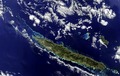
English: The New Caledonia archipelago, 1210 km east of Australia, is captured in this Envisat image, acquired on 5 July 2011. The main island, Grande Terre, dominates the image, stretching 350 km long from northwest to southeast. A mountain range runs the length of the island – its highest point reaching over 1620 m – and divides the land’s lush east from the savannahs in the west. A coral reef surrounds the main island and stretches into the Coral Sea to the northwest. The reef provides an important nesting site for green sea turtles and is home to endangered dugongs.
This image is featured on theEarth from Space video programme. |
| Fecha | |
| Fuente | http://www.esa.int/spaceinimages/Images/2013/02/New_Caledonia |
| Autor | European Space Agency |
| Permiso (Reutilización de este archivo) |
ESA,CC BY-SA 3.0 IGO |
| Otras versiones |
|
| Title | New Caledonia |
| System | Envisat Satellite |
| Keywords | Coral; Islands |
| Set | Earth observation image of the week |
| Mission | Envisat |
| Activity | Observing the Earth |
Licencia
Este archivo se encuentra bajo la licencia Creative Commons Atribución Compartir-Igual 3.0 IGO.
Atribución: ESA
- Eres libre:
- de compartir – de copiar, distribuir y transmitir el trabajo
- de remezclar – de adaptar el trabajo
- Bajo las siguientes condiciones:
- atribución – Debes otorgar el crédito correspondiente, proporcionar un enlace a la licencia e indicar si realizaste algún cambio. Puedes hacerlo de cualquier manera razonable pero no de manera que sugiera que el licenciante te respalda a ti o al uso que hagas del trabajo.
- compartir igual – En caso de mezclar, transformar o modificar este trabajo, deberás distribuir el trabajo resultante bajo la misma licencia o una compatible como el original.
Historial del archivo
Haz clic sobre una fecha y hora para ver el archivo tal como apareció en ese momento.
| Fecha y hora | Miniatura | Dimensiones | Usuario | Comentario | |
|---|---|---|---|---|---|
| actual | 01:51 22 feb 2017 | | 2318 × 1465 (1,41 MB) | Revent | =={{int:filedesc}}== {{Photograph |photographer = Envisat satellite |title = New Caledonia |description = {{en|The New Caledonia archipelago, 1210 km east of Australia, is captured in this Envisat image, acquired on 5 July... |
Usos del archivo
Las siguientes páginas usan este archivo:
Uso global del archivo
Las wikis siguientes utilizan este archivo:
- Uso en en.wikipedia.org