
Archivo:NYTMap2ndBattleOfYpres1915.png
NYTMap2ndBattleOfYpres1915.png (480 × 571 píxeles; tamaño de archivo: 69 kB; tipo MIME: image/png)
| Descripción |
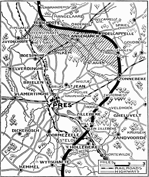
"Current History" (New York Times) map showing reported positions during the Second Battle of Ypres, as at about 30 April 1915. On 1 May the British withdrew to shorten their lines, with the final front line running through Hooge, Frenzenberg (not shown, but 1 3/4 mile sw of Zonnebeke) and west to Mouse Trap farm and Turco farms (not shown, but 1 mile sw of St Julien).
NYT caption : "The German rush across the Yser-Ypres Canal was checked at Lizerne and opposite Boesinghe. The shaded area on the map marks the scene of the battle. Within this area are Steenstraate, Het Sast, Pilkem, St. Julien, and Langemarck, all of which the Germans claimed to have captured." |
| Fecha | |
| Fuente |
New York Times Current History. The European War, Vol. 2 No. 3, June 1915. Downloaded from http://www.gutenberg.org/ebooks/15480 |
| Autor | "Current History" (New York Times) |
Este archivo está en el dominio público en los Estados Unidos. Esto se aplica a los trabajos de Estados Unidos donde los derechos de autor han expirado, a menudo porque su primera publicación ocurrió antes del 1 de enero de 1929. Véase esta página para explicación adicional.
|
 | |
 |
Esta imagen puede estar protegida fuera de los Estados Unidos —especialmente en Canadá, China (excepto Hong-Kong, Macao, o el área de Taiwán), Alemania o Suiza—. El creador y el año de publicación son información esencial y deben ser proporcionados. Véase Wikipedia:Derechos de autor para más detalles.
|
Historial del archivo
Haz clic sobre una fecha y hora para ver el archivo tal como apareció en ese momento.
| Fecha y hora | Miniatura | Dimensiones | Usuario | Comentario | |
|---|---|---|---|---|---|
| actual | 10:26 13 feb 2008 | | 480 × 571 (69 kB) | Rcbutcher | {{Information |Description=New York Times map showing reported positions after the Second Battle of Ypres, April - May 1915. <br>NYT caption : "The German rush across the Yser-Ypres Canal was checked at Lizerne and opposite Boesinghe. The shaded area on t |
Usos del archivo
La siguiente página usa este archivo:
Uso global del archivo
Las wikis siguientes utilizan este archivo:
- Uso en de.wikipedia.org
- Uso en en.wikipedia.org
- Uso en fr.wikipedia.org
- Uso en he.wikipedia.org
- Uso en it.wikipedia.org
- Uso en nl.wikipedia.org