
Archivo:Mount Mazama eruption timeline.PNG
Ver la imagen en su resolución original (250 × 841 píxeles; tamaño de archivo: 187 kB; tipo MIME: image/png)
Resumen
| Descripción |
|
| Fuente | http://pubs.usgs.gov/fs/2002/fs092-02/ (saved as PNG) |
| Autor | U.S. GEOLOGICAL SURVEY and the NATIONAL PARK SERVICE |
| Otras versiones |
    |

|
Esta imagen debería volverse a crear como imágenes vectoriales SVG. Esto proporciona muchas ventajas, véase Commons:Media for cleanup (en inglés) para más información. Si ya hay una versión SVG de esta imagen disponible, por favor súbala a Commons. Tras subirla, reemplace esta plantilla con la plantilla
{{vector version available|nuevo nombre de imagen.svg}} en esta imagen. |
Licencia
Esta imagen está en el dominio público, ya que contiene materiales que originalmente vinieron del Servicio Geológico de los Estados Unidos de América, una agencia del Departamento del Interior. Para obtener más información, consulte la política oficial de derechos de los USGS.
|
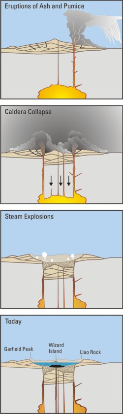
Crater Lake is an example, it is located in Oregen and was made from a valcano, making a caldera.
Historial del archivo
Haz clic sobre una fecha y hora para ver el archivo tal como apareció en ese momento.
| Fecha y hora | Miniatura | Dimensiones | Usuario | Comentario | |
|---|---|---|---|---|---|
| actual | 05:24 29 mar 2006 | 250 × 841 (187 kB) | Jkelly | Source: http://pubs.usgs.gov/fs/2002/fs092-02/ (saved as PNG) Author: U.S. GEOLOGICAL SURVEY and the NATIONAL PARK SERVICE Description: <blockquote>Cataclysmic eruption to present. Eruptions of ash and pumice: The cataclysmic eruption started from a ve |
Usos del archivo
Las siguientes páginas usan este archivo:
Uso global del archivo
Las wikis siguientes utilizan este archivo:
- Uso en af.wikipedia.org
- Uso en an.wikipedia.org
- Uso en ar.wikipedia.org
- Uso en ast.wikipedia.org
- Uso en br.wikipedia.org
- Uso en ce.wikipedia.org
- Uso en cy.wikipedia.org
- Uso en de.wikipedia.org
- Uso en en.wikipedia.org
- Uso en en.wikiversity.org
- Uso en eo.wikipedia.org
- Uso en fa.wikipedia.org
- Uso en fi.wikipedia.org
- Uso en fr.wikipedia.org
- Uso en id.wikipedia.org
- Uso en it.wikipedia.org
- Uso en ja.wikipedia.org
- Uso en ko.wikipedia.org
- Uso en lv.wikipedia.org
- Uso en min.wikipedia.org
- Uso en mk.wikipedia.org
- Uso en ml.wikipedia.org
- Uso en pt.wikipedia.org
- Uso en ru.wikipedia.org
- Uso en simple.wikipedia.org
- Uso en sk.wikipedia.org
- Uso en sr.wikipedia.org
- Uso en su.wikipedia.org
- Uso en vi.wikipedia.org
- Uso en www.wikidata.org