Archivo:Mjo north america rain.png

Contenido de la página no disponible en otros idiomas.
De Wikipedia, la enciclopedia libre

Ver la imagen en su resolución original(556 × 749 píxeles; tamaño de archivo: 28 kB; tipo MIME: image/png)

Descripción
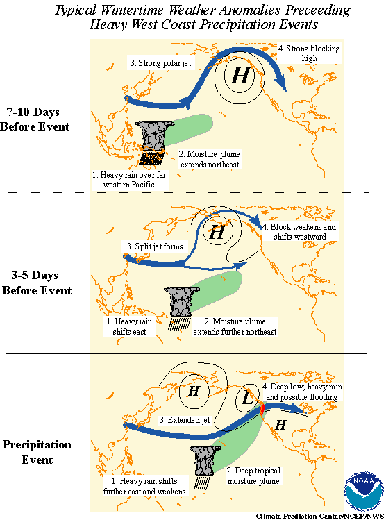
English: Madden-Julian oscillation effects upon North American weather patterns. Eastward-moving tropical rainfall circulation drives north Pacific Ocean atmospheric circulation changes.

Here are the 3 progressive steps:

  • 7-10 days prior to the heavy precipitation event, heavy tropical rainfall associated with the MJO shifts eastward from the eastern Indian Ocean to the western tropical Pacific. A moisture plume extends northeastward from the western tropical Pacific towards the general vicinity of the Hawaiian Islands. A strong blocking anticyclone is located in the Gulf of Alaska with a strong polar jet stream around its northern flank.
  • 3-5 days prior to the heavy precipitation event, heavy tropical rainfall shifts eastward towards the date line and begins to diminish. The associated moisture plume extends further to the northeast, often traversing the Hawaiian Islands. The strong blocking high weakens and shifts westward. A split in the North Pacific jet stream develops, characterized by an increase in the amplitude and areal extent of the upper tropospheric westerly zonal winds on the southern flank of the block and a decrease on its northern flank. The tropical and extratropical circulation patterns begin to "phase", allowing a developing midlatitude trough to tap the moisture plume extending from the deep tropics.
  • As the pattern of enhanced tropical rainfall continues to shift further to the east and weaken, the deep tropical moisture plume extends from the subtropical central Pacific into the midlatitude trough now located off the west coast of North America. The jet stream at upper levels extends across the North Pacific with the mean jet position entering North America in the northwestern United States. Deep low pressure located near the Pacific Northwest coast can bring up to several days of heavy rain and possible flooding. These events are often referred to as "pineapple express" events, so named because a significant amount of the deep tropical moisture traverses the Hawaiian Islands on its way towards western North America.
Fecha
Fuente NOAA in article Monitoring Interseasonal Oscillations
Autor Pierre_cb
Permiso
(Reutilización de este archivo)
Public domain
Esta imagen es de dominio público porque contiene material que vino originalmente de la Administración Nacional Oceánica y Atmosférica de los Estados Unidos de América, recibidas o hechas en el curso de las funciones oficiales de un empleado.

العربية  čeština  Deutsch  Zazaki  English  español  eesti  suomi  français  hrvatski  magyar  italiano  日本語  한국어  македонски  മലയാളം  Plattdüütsch  Nederlands  polski  português  română  русский  sicilianu  slovenščina  Türkçe  Tiếng Việt  简体中文  繁體中文  +/−

Otras versiones French in File:Mjo north america rain f.png.
Esta imagen debería volverse a crear como imágenes vectoriales SVG. Esto proporciona muchas ventajas, véase Commons:Media for cleanup (en inglés) para más información. Si ya hay una versión SVG de esta imagen disponible, por favor súbala a Commons. Tras subirla, reemplace esta plantilla con la plantilla {{vector version available|nuevo nombre de imagen.svg}} en esta imagen.

Historial del archivo

Haz clic sobre una fecha y hora para ver el archivo tal como apareció en ese momento.

Fecha y horaMiniaturaDimensionesUsuarioComentario
actual16:01 25 ago 2010Miniatura de la versión del 16:01 25 ago 2010556 × 749 (28 kB)Pierre cbEnglish version
01:35 24 dic 2006Miniatura de la versión del 01:35 24 dic 2006557 × 667 (50 kB)Pierre cb{{Information |Description=Madden-Julian oscillation effects upon North American weather patterns. Eastward-moving tropical rainfall circulation drives north Pacific Ocean atmospheric circulation changes. |Source= [http://www.cpc.ncep.noaa.gov/p

La siguiente página usa este archivo:

Uso global del archivo