
Archivo:Map of the southern Balkans, 1410-es.svg

Tamaño de esta previsualización PNG del archivo SVG: 679 × 600 píxeles. Otras resoluciones: 272 × 240 píxeles · 543 × 480 píxeles · 869 × 768 píxeles · 1159 × 1024 píxeles · 2318 × 2048 píxeles · 2217 × 1959 píxeles.
Ver la imagen en su resolución original ((Imagen SVG, nominalmente 2217 × 1959 pixels, tamaño de archivo: 2,76 MB))
Resumen
| Descripción |
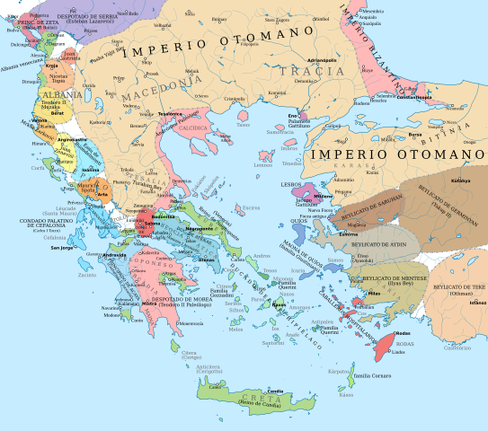
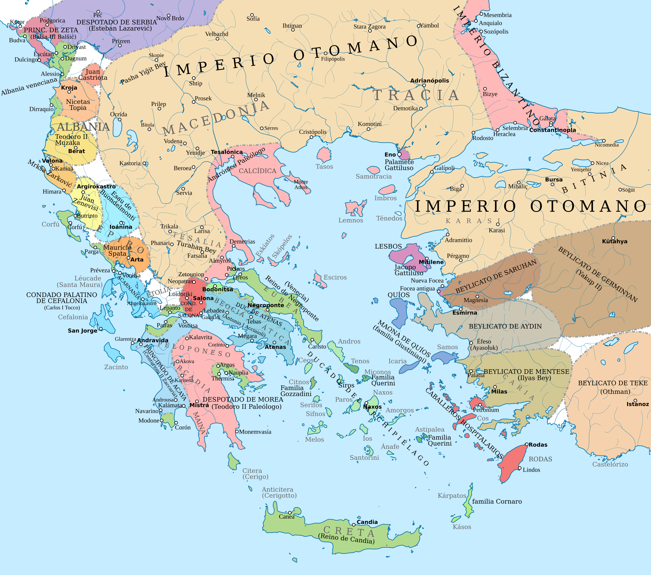
English: Political map of the southern Balkans and western Anatolia in 1410. Disclaimer: The borders shown are often uncertain and conjectural; an effort has been made to be as accurate as possible and follow the relevant scholarship, but errors or omissions may still be present. Any help in correcting and/or improving this work would be greatly appreciated.
Sources: Basic map sources:
Southern Greece and Latin states in the Aegean and the Balkans:
Epirus, Albania, Montenegro:
Northern Greece:
Boundaries of the Byzantine Empire:
Ottoman Empire and Anatolian beyliks:
|
| Fuente |
Este archivo deriva de: Map of the southern Balkans, 1410.svg |
| Autor | Constantine Plakidas |
Licencia
Este archivo está disponible bajo la licencia Creative Commons Attribution-Share Alike 4.0 International.
- Eres libre:
- de compartir – de copiar, distribuir y transmitir el trabajo
- de remezclar – de adaptar el trabajo
- Bajo las siguientes condiciones:
- atribución – Debes otorgar el crédito correspondiente, proporcionar un enlace a la licencia e indicar si realizaste algún cambio. Puedes hacerlo de cualquier manera razonable pero no de manera que sugiera que el licenciante te respalda a ti o al uso que hagas del trabajo.
- compartir igual – En caso de mezclar, transformar o modificar este trabajo, deberás distribuir el trabajo resultante bajo la misma licencia o una compatible como el original.
Historial del archivo
Haz clic sobre una fecha y hora para ver el archivo tal como apareció en ese momento.
| Fecha y hora | Miniatura | Dimensiones | Usuario | Comentario | |
|---|---|---|---|---|---|
| actual | 06:43 23 ago 2021 | | 2217 × 1959 (2,76 MB) | Rowanwindwhistler | Background updated from source map |
| 16:41 16 jul 2019 |  | 2217 × 1959 (2,76 MB) | Rowanwindwhistler | Uploading a file from a free published source using File Upload Wizard |
Usos del archivo
Las siguientes páginas usan este archivo:
Uso global del archivo
Las wikis siguientes utilizan este archivo:
- Uso en fr.wikipedia.org