Archivo:Map of eastern Xinjiang 1939 with prehistoric sites and the courses of the Silk Roads.jpg

Contenido de la página no disponible en otros idiomas.
De Wikipedia, la enciclopedia libre

Ver la imagen en su resolución original(831 × 777 píxeles; tamaño de archivo: 297 kB; tipo MIME: image/jpeg)

Descripción
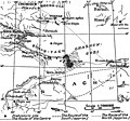
English: Map of eastern Xinjiang with prehistoric sites and the courses of the Silk Roads by Folke Bergman 1939.
Deutsch: Landkarte von Folke Bergman vom östlichen Xinjiang aus dem Jahr 1939 mit prähistorischen Fundstätten und den Routen der Seidenstraße. Bilderklärungen: . Prähistorische Fundstätte, ...... mittlere Route, — — — — vermutete südliche Route, - - - - - vermutete nördliche Route.
Fecha created: 1939 after the Sino-Swedish Expedition in China 1927-1933.
Fuente Map of eastern Xinjiang with prehistoric sites and the courses of the Silk Roads by Folke Bergman in his Book Archaeological Researches in Sinkiang. Especially the Lop-Nor Region. (Reports: Publication 7), Stockholm 1939, Page 25 Fig. 4. Copyright 2006: Sven Hedin foundation, Stockholm. [1]
Autor Folke Bergman
Permiso
(Reutilización de este archivo)

Permission cc-by-2.5 from the date 2006.08.23 by the keeper of the Sven Hedin Foundation Håkan Wahlquist, Box 27 140, SE-102 52 Stockholm, Sweden, Phone: +46-8-519 550 18, fax: +46-8-519 550 70, e-mail: hakan.wahlquist@etnografiska.se [2]

Svenska: Du måste ange upphovsmannen och/eller licensgivaren på det sätt de anger: Sven Hedin Foundation, Stockholm.
Deutsch: Namensnennung: Sie müssen den Namen des Autors/Rechtsinhabers Sven Hedin Foundation nennen: Sven Hedin Foundation, Stockholm.
w:es:Creative Commons
atribución
Este archivo está disponible bajo la licencia Creative Commons Reconocimiento 2.5 Genérica.
Eres libre:
  • de compartir – de copiar, distribuir y transmitir el trabajo
  • de remezclar – de adaptar el trabajo
Bajo las siguientes condiciones:
  • atribución – Debes otorgar el crédito correspondiente, proporcionar un enlace a la licencia e indicar si realizaste algún cambio. Puedes hacerlo de cualquier manera razonable pero no de manera que sugiera que el licenciante te respalda a ti o al uso que hagas del trabajo.

Leyendas

Añade una explicación corta acerca de lo que representa este archivo

Elementos representados en este archivo

representa a

Historial del archivo

Haz clic sobre una fecha y hora para ver el archivo tal como apareció en ese momento.

Fecha y horaMiniaturaDimensionesUsuarioComentario
actual14:00 18 sep 2006Miniatura de la versión del 14:00 18 sep 2006831 × 777 (297 kB)Michael Gäbler{{Information| |Description= Map of eastern Xinjiang with prehistoric sites and the courses of the Silk Roads by Folke Bergman 1939. de: Landkarte von Folke Bergman vom östlichen Xinjiang aus dem Jahr 1939 mit prehistorischen Fundstätten und den Routen

No hay páginas que enlacen a este archivo.

Uso global del archivo

Las wikis siguientes utilizan este archivo:

Metadatos