
Archivo:Looking north at LEnfant Plaza - Washington DC.jpg

Tamaño de esta previsualización: 800 × 505 píxeles. Otras resoluciones: 320 × 202 píxeles · 640 × 404 píxeles · 1024 × 646 píxeles · 1280 × 807 píxeles · 2912 × 1837 píxeles.
Ver la imagen en su resolución original (2912 × 1837 píxeles; tamaño de archivo: 1,14 MB; tipo MIME: image/jpeg)
Resumen
| Descripción |
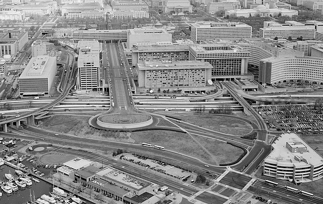
English: Aerial photograph looking north at L'Enfant Plaza, L'Enfant Promenade, and part of Southwest, Washington, D.C. (1992).
|
| Fecha | |
| Fuente | http://lcweb2.loc.gov/cgi-bin/displayPhoto.pl?path=/pnp/habshaer/dc/dc0700/dc0776/photos&topImages=042585pr.jpg |
| Autor | U.S. National Park Service, Historic American Building Survey. John McWilliams, photographer. |
Licencia

|
Este archivo proviene del Servicio de Edificios Históricos de Estados Unidos (HABS), el Programa Registro de Ingeniería Histórica de Estados Unidos (HAER), o de la Encuesta de Hitos Históricos de Estados Unidos (HALS). Estos son programas del Servicio de Parques Nacionales establecido para el propósito de documentar sitios históricos. Los archivos contienen dibujos de medidas, fotografías de archivo, y informes escritos.
Esta etiqueta no indica el estado de los derechos de autor del trabajo adjunto. Se requiere una etiqueta de derechos de autor normal. Para más información vea Commons:Sobre las licencias. |
| Este archivo contiene material basado en un trabajo de algún empleado de la National Park Service (Servicio de Parques Nacionales), creado durante su prestación oficial de servicio. Por lo tanto, es un trabajo del Gobierno Federal de los Estados Unidos, revistiendo en el dominio público. Véase el sitio web de la NPS y su política de derechos de autor para más información. |
| Annotations | This image is annotated: View the annotations at Commons |
Historial del archivo
Haz clic sobre una fecha y hora para ver el archivo tal como apareció en ese momento.
| Fecha y hora | Miniatura | Dimensiones | Usuario | Comentario | |
|---|---|---|---|---|---|
| actual | 17:32 6 mar 2011 | | 2912 × 1837 (1,14 MB) | Tim1965 | {{Information |Description ={{en|1=Aerial photograph looking north at L'Enfant Plaza. The Potomac River waterfront is at the bottom of the image. The six-lane divided street that is Maine Avenue SW can be seen just above the waterfront and its buildi |
Usos del archivo
La siguiente página usa este archivo:
Uso global del archivo
Las wikis siguientes utilizan este archivo:
- Uso en en.wikipedia.org
- Uso en ru.wikipedia.org
- Uso en www.wikidata.org
- Uso en zh.wikipedia.org