
Archivo:Kirkby Town Centre - geograph.org.uk - 122465.jpg
No se dispone de una resolución más alta.
Kirkby_Town_Centre_-_geograph.org.uk_-_122465.jpg (640 × 480 píxeles; tamaño de archivo: 60 kB; tipo MIME: image/jpeg)
Resumen
| Descripción |
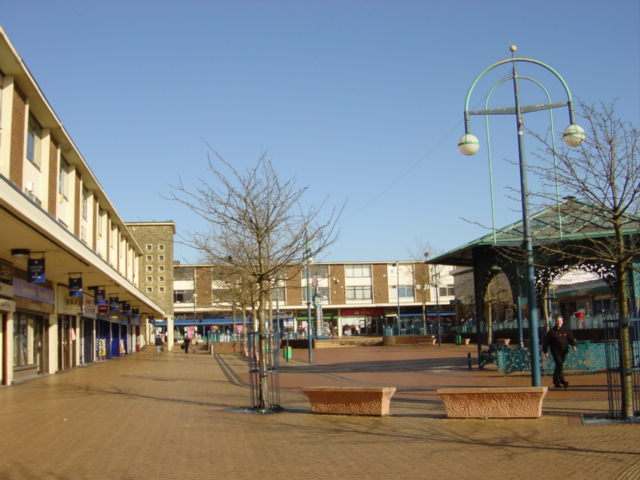
English: Kirkby centre. Looking north from Newtown Gardens.
The "Newtown" (remember Z cars?) of Kirkby owes its being to the closure of the Royal Ordnance Factory in 1946 when the Government suggested to Liverpool City Council that making use of some of the thousand buildings and creating a large trading/industrial estate would provide jobs for redundant workers and the demobbed. The trading estate steadily expanded through the 1950s and 1960s to become one of the largest in the country, at its peak in 1971, the estate employed over 26,000 people. A model town of 10,000 houses was constructed, mainly as an overspill for Liverpool, on what was once agricultural land and the modest population of 3,000 expanded to 50,000 by 1961. New facilities to cater for the growing population included a variety of shops, banks and business premises, a library and a market, probably the only surviving outdoor market on Merseyside. |
| Fecha | |
| Fuente | From geograph.org.uk |
| Autor | Sue Adair |
| Atribución (requerido por la licencia) | Sue Adair / Kirkby Town Centre / |
| Ubicación del objeto | | Ubicación de esta y otras imágenes en: OpenStreetMap |
|---|
_&language=es)
Licencia

|
Esta imagen proviene de la colección del proyecto Geograph British Isles. Veáse la página de esta fotografía en el sitio web de Geograph para más información del fotógrafo. El titular de los derechos de autor de esta imagen es Sue Adair y autoriza utilizarla bajo la licencia Reconocimiento-CompartirIgual 2.0 de Creative Commons.
|
Este archivo se encuentra bajo la licencia Creative Commons Genérica de Atribución/Compartir-Igual 2.0.
Atribución: Sue Adair
- Eres libre:
- de compartir – de copiar, distribuir y transmitir el trabajo
- de remezclar – de adaptar el trabajo
- Bajo las siguientes condiciones:
- atribución – Debes otorgar el crédito correspondiente, proporcionar un enlace a la licencia e indicar si realizaste algún cambio. Puedes hacerlo de cualquier manera razonable pero no de manera que sugiera que el licenciante te respalda a ti o al uso que hagas del trabajo.
- compartir igual – En caso de mezclar, transformar o modificar este trabajo, deberás distribuir el trabajo resultante bajo la misma licencia o una compatible como el original.
- Remove redundant categories and try to put this image in the most specific category/categories
- Remove this template
- The location categories are based on information from this geonames tool and this OpenStreetMap tool combined with a database. You can also have a look at this tool from mysociety.
- The topic category from Geograph was Kirkby centre (find similar images centre at Geograph)
Historial del archivo
Haz clic sobre una fecha y hora para ver el archivo tal como apareció en ese momento.
| Fecha y hora | Miniatura | Dimensiones | Usuario | Comentario | |
|---|---|---|---|---|---|
| actual | 03:31 31 ene 2010 | | 640 × 480 (60 kB) | GeographBot | == {{int:filedesc}} == {{Information |description={{en|1=Kirkby Town Centre. Looking north from Newtown Gardens to Kirkby town centre. The "Newtown" (remember Z cars?) of Kirkby owes its being to the closure of the Royal Ordnance Factory in 1946 when the |
Usos del archivo
La siguiente página usa este archivo:
Uso global del archivo
Las wikis siguientes utilizan este archivo:
- Uso en ar.wikipedia.org
- Uso en be.wikipedia.org
- Uso en ceb.wikipedia.org
- Uso en cy.wikipedia.org
- Uso en de.wikipedia.org
- Uso en en.wikipedia.org
- Uso en it.wikipedia.org
- Uso en lld.wikipedia.org
- Uso en pl.wikipedia.org
- Uso en ro.wikipedia.org
- Uso en ru.wikipedia.org
- Uso en sv.wikipedia.org
- Uso en www.wikidata.org