
Archivo:Kentucky County, Virginia 1776.png
No se dispone de una resolución más alta.
Kentucky_County,_Virginia_1776.png (638 × 300 píxeles; tamaño de archivo: 145 kB; tipo MIME: image/png)
Resumen
| Descripción |
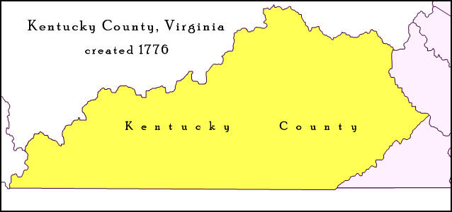
English: Map of Trans-Appalachian Virginia as it was from 1776 to 1780. Kentucky County (then alternately spelled Kentucke County) was created by the Commonwealth of Virginia from the western portion of Fincastle County beyond the Cumberland Mountains effective December 31, 1776, and was in existence until June 30, 1780, when it was subdivided and abolished. |
| Fecha | |
| Fuente | Trabajo propio; map detail from Virginia's Western Counties 1776, Geographic Materials: Neal Hammon Series, Office of the Kentucky Secretary of State, Frankfort, Kentucky. |
| Autor | Drdpw |
Licencia
Yo, el titular de los derechos de autor de esta obra, la publico en los términos de la siguiente licencia:
Este archivo está disponible bajo la licencia Creative Commons Attribution-Share Alike 4.0 International.
- Eres libre:
- de compartir – de copiar, distribuir y transmitir el trabajo
- de remezclar – de adaptar el trabajo
- Bajo las siguientes condiciones:
- atribución – Debes otorgar el crédito correspondiente, proporcionar un enlace a la licencia e indicar si realizaste algún cambio. Puedes hacerlo de cualquier manera razonable pero no de manera que sugiera que el licenciante te respalda a ti o al uso que hagas del trabajo.
- compartir igual – En caso de mezclar, transformar o modificar este trabajo, deberás distribuir el trabajo resultante bajo la misma licencia o una compatible como el original.
Historial del archivo
Haz clic sobre una fecha y hora para ver el archivo tal como apareció en ese momento.
| Fecha y hora | Miniatura | Dimensiones | Usuario | Comentario | |
|---|---|---|---|---|---|
| actual | 21:45 10 abr 2018 | | 638 × 300 (145 kB) | Drdpw | User created page with UploadWizard |
Usos del archivo
La siguiente página usa este archivo:
Uso global del archivo
Las wikis siguientes utilizan este archivo:
- Uso en de.wikipedia.org
- Uso en en.wikipedia.org
- Uso en pt.wikipedia.org
- Uso en ur.wikipedia.org