
Archivo:Iron age strap union (FindID 53821).jpg

Tamaño de esta previsualización: 495 × 599 píxeles. Otras resoluciones: 198 × 240 píxeles · 397 × 480 píxeles · 838 × 1014 píxeles.
Ver la imagen en su resolución original (838 × 1014 píxeles; tamaño de archivo: 185 kB; tipo MIME: image/jpeg)
Resumen
| Iron age strap union | |||
|---|---|---|---|
| Fotógrafo |
Suffolk County Council, Ciorstaidh Hayward Trevarthen, 2003-11-05 10:35:02 |
||
| Título |
Iron age strap union |
||
| Descripción |
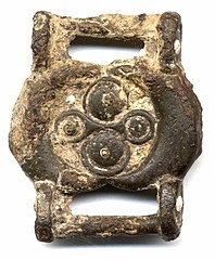
English: Copper alloy double-sided strap union. The oval central plate element has a frame of two raised crescents forming a central circular recess. On one side in the recess are two large raised ring and dot/ roundel decorations flanking two smaller ring and dots with a continuous frame forming an hourglass shape. At the centre of each of the roundels on the first side is a slight projection. This design is mirrored on the other side, although it is obscured by heavy corrosion. Instead of the domed roundels, on the second side these elements are flatter and each have a central spike that would have held a disc of coral (now missing). At either side of the oval central plate longitudinally is a circular sectioned attachment bar. These are attached on round-ended lugs projecting from the sides of the plate. These lugs are decorated with a white dot on the outer face. This is may be enamel. The strap union is quite thickly cast with a figure of eight profile. |
||
| Lugar representado | (County of findspot) Dorset | ||
| Fecha | IRON AGE | ||
| Número de inventario |
FindID: 53821 Old ref: SOMDOR-CF0B77 Filename: STRAPUNIONf.JPG |
||
| Adquisición |
|
||
| Fuente |
https://finds.org.uk/database/ajax/download/id/12020 Catalog: https://finds.org.uk/database/images/image/id/12020/recordtype/artefacts archive copy at the Wayback Machine Artefact: https://finds.org.uk/database/artefacts/record/id/53821 |
||
| Permiso (Reutilización de este archivo) |
Attribution-ShareAlike License version 4.0 (verified 23 de noviembre de 2020) | ||
| Otras versiones |
|
||
.jpg)
.jpg?uselang=es)
| Ubicación del objeto | | Ubicación de esta y otras imágenes en: OpenStreetMap |
|---|
.jpg¶ms=050.723200_N_-002.644660_E_globe:Earth_class:object_type:object__&language=es)
Licencia
Este archivo está disponible bajo la licencia Creative Commons Attribution-Share Alike 4.0 International.
Atribución: The Portable Antiquities Scheme/ The Trustees of the British Museum
- Eres libre:
- de compartir – de copiar, distribuir y transmitir el trabajo
- de remezclar – de adaptar el trabajo
- Bajo las siguientes condiciones:
- atribución – Debes otorgar el crédito correspondiente, proporcionar un enlace a la licencia e indicar si realizaste algún cambio. Puedes hacerlo de cualquier manera razonable pero no de manera que sugiera que el licenciante te respalda a ti o al uso que hagas del trabajo.
- compartir igual – En caso de mezclar, transformar o modificar este trabajo, deberás distribuir el trabajo resultante bajo la misma licencia o una compatible como el original.
Historial del archivo
Haz clic sobre una fecha y hora para ver el archivo tal como apareció en ese momento.
| Fecha y hora | Miniatura | Dimensiones | Usuario | Comentario | |
|---|---|---|---|---|---|
| actual | 16:24 30 ene 2017 | | 838 × 1014 (185 kB) | Fæ | Portable Antiquities Scheme, DOR, FindID: 53821, iron age, page 602, batch count 10500 |
Usos del archivo
La siguiente página usa este archivo:
Uso global del archivo
Las wikis siguientes utilizan este archivo:
- Uso en ca.wikipedia.org
- Uso en en.wikipedia.org
- Uso en vi.wikipedia.org
- Uso en www.wikidata.org
.jpg)