
Archivo:ISS-30 Lake Fitri, Chad.jpg
Tamaño de esta previsualización: 800 × 531 píxeles. Otras resoluciones: 320 × 213 píxeles · 640 × 425 píxeles · 1024 × 680 píxeles · 1280 × 850 píxeles · 2560 × 1700 píxeles · 4288 × 2848 píxeles.
Ver la imagen en su resolución original (4288 × 2848 píxeles; tamaño de archivo: 6,37 MB; tipo MIME: image/jpeg)
Resumen
| Descripción |
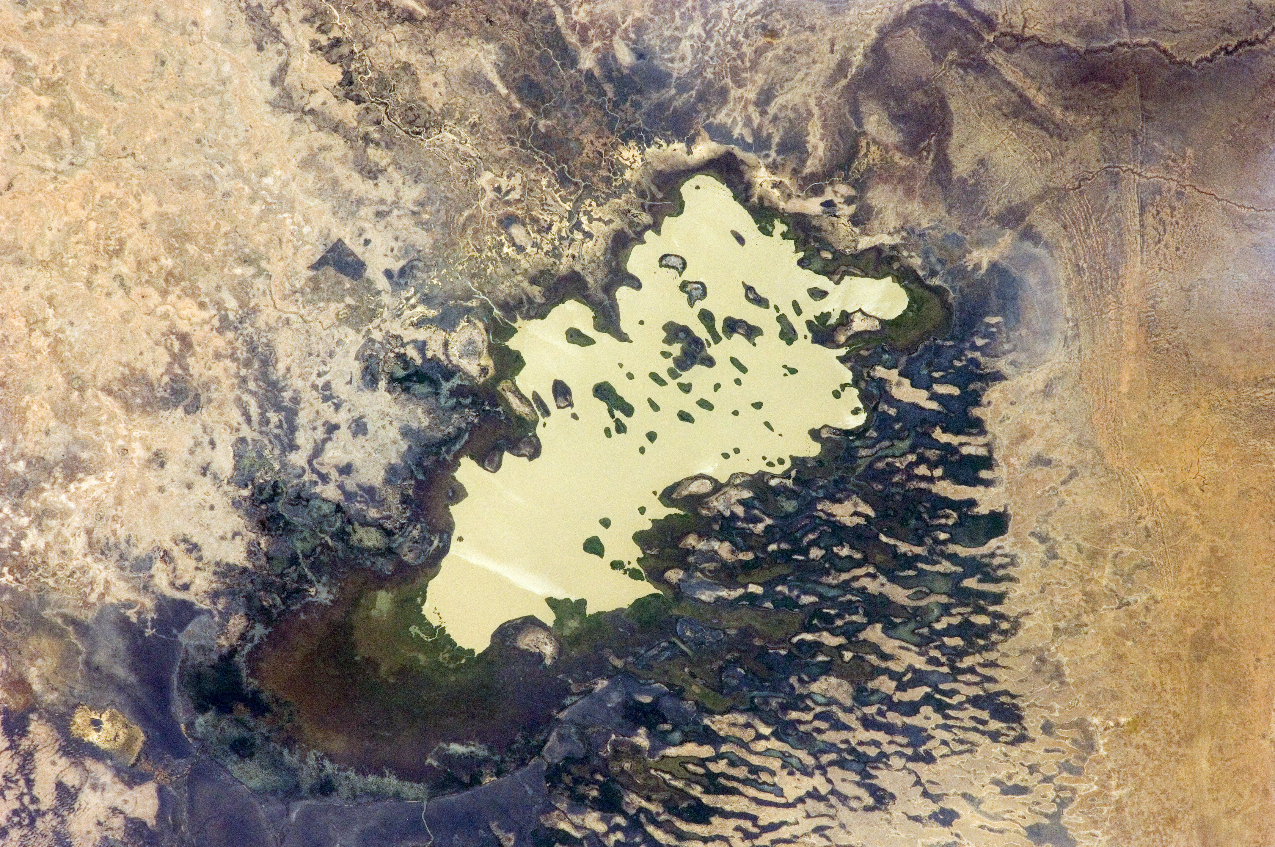
English: Lake Fitri, Chad is featured in this image photographed by an Expedition 30 crew member on the International Space Station.
|
| Fecha | |
| Fuente | http://spaceflight.nasa.gov/gallery/images/station/crew-30/html/iss030e059398.html |
| Autor | NASA |
Este archivo fue catalogado por Johnson Space Center de la Administración Nacional de Aeronáutica y del Espacio (NASA) de los Estados Unidos de Américabajo el identificador de foto: ISS030-E-059398.Esta etiqueta no indica el estado de los derechos de autor del trabajo adjunto. Se requiere una etiqueta de derechos de autor normal. Para más información vea Commons:Sobre las licencias. Otros idiomas:
|
Licencia
"The Gateway to Astronaut Photography of Earth". Imagen cortesía de Image Science & Analysis Laboratory, NASA Johnson Space Center.
Fuente de la foto: ISS030-E-59398.
|
Historial del archivo
Haz clic sobre una fecha y hora para ver el archivo tal como apareció en ese momento.
| Fecha y hora | Miniatura | Dimensiones | Usuario | Comentario | |
|---|---|---|---|---|---|
| actual | 20:00 20 abr 2016 | | 4288 × 2848 (6,37 MB) | Ras67 | new rendered in high quality from NASA's raw image data |
| 12:46 4 jun 2012 |  | 4288 × 2848 (2,03 MB) | Ras67 | levels | |
| 17:59 21 feb 2012 |  | 4288 × 2848 (1,76 MB) | Ras67 | {{Information |Description ={{en|1=Lake Fitri, Chad is featured in this image photographed by an Expedition 30 crew member on the International Space Station. Lake Fitri is an endorheic, or terminal lake in a desert basin in the southern Sahara Desert. |
Usos del archivo
Las siguientes páginas usan este archivo:
Uso global del archivo
Las wikis siguientes utilizan este archivo:
- Uso en ar.wikipedia.org
- Uso en arz.wikipedia.org
- Uso en be.wikipedia.org
- Uso en cv.wikipedia.org
- Uso en de.wikipedia.org
- Uso en el.wikipedia.org
- Uso en en.wikipedia.org
- Uso en fr.wikipedia.org
- Uso en id.wikipedia.org
- Uso en it.wikipedia.org
- Uso en ka.wikipedia.org
- Uso en lt.wikipedia.org
- Uso en my.wikipedia.org
- Uso en nl.wikipedia.org
- Uso en pl.wikipedia.org
- Uso en ru.wikipedia.org
- Uso en uk.wikipedia.org
- Uso en vi.wikipedia.org
- Uso en www.wikidata.org