
Archivo:Hurricane Philippe on September 18 2005.jpg

Ver la imagen en su resolución original (7000 × 7000 píxeles; tamaño de archivo: 6,58 MB; tipo MIME: image/jpeg)
Resumen
| Descripción |
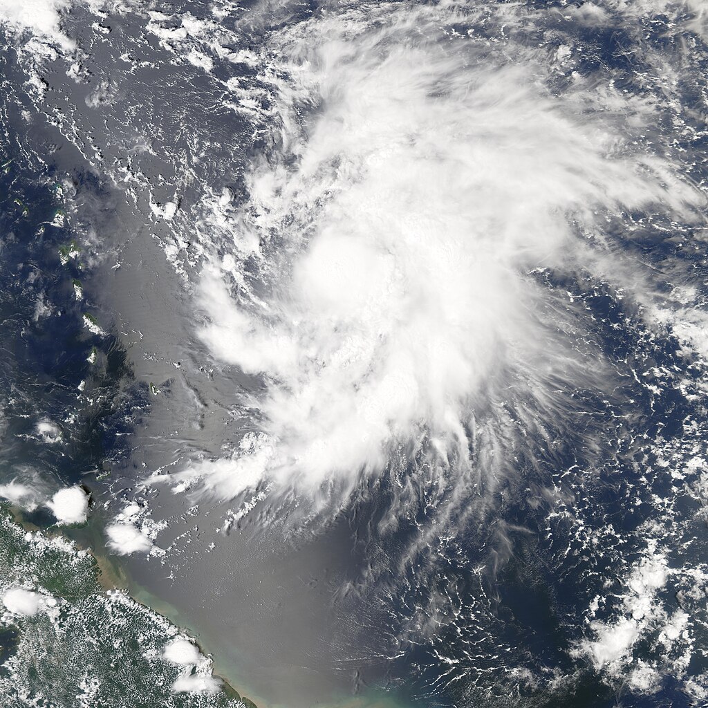
A tropical depression formed off the Brazilian coast on September 17, 2005. Once it was organized enough to have winds of over 62 kilometers per hour (39 miles per hour), it was classified as a tropical storm and given the name Philippe, becoming the 16th named storm system of the 2005 hurricane season. It continued to gather strength, becoming a category 1 hurricane just 24 hours later. Adding Philippe and Rita to the roster of storms in 2005, the year has already become one most active Atlantic hurricane seasons since records were started in 1851. The Moderate Resolution Imaging Spectroradiometer (MODIS) on NASA’s Aqua satellite captured this image of Philippe at 1:05 p.m. local time while the storm was still not quite at hurricane strength, though it would reach this status only hours later. Philippe has the classic spiral structure of a hurricane, but there is little evidence yet of a well-defined eye in the storm’s center. Forecasters were not too concerned about Philippe at the time of the satellite pass. The projected storm track will take Philippe nearly directly north, grazing the Antilles Island chain and perhaps Bermuda. But it was not predicted to make landfall or pose significant danger or threats to coastal areas. |
|||||
| Fecha | ||||||
| Fuente | http://earthobservatory.nasa.gov/NaturalHazards/natural_hazards_v2.php3?img_id=13140 | |||||
| Autor | NASA image created by Jesse Allen, Earth Observatory, using data obtained courtesy of the MODIS Rapid Response team. | |||||
| Permiso (Reutilización de este archivo) |
|

Historial del archivo
Haz clic sobre una fecha y hora para ver el archivo tal como apareció en ese momento.
| Fecha y hora | Miniatura | Dimensiones | Usuario | Comentario | |
|---|---|---|---|---|---|
| actual | 18:03 29 jul 2006 | | 7000 × 7000 (6,58 MB) | Good kitty | |
| 19:34 21 sep 2005 |  | 7000 × 7000 (4,23 MB) | Tom | ==Description== A tropical depression formed off the Brazilian coast on September 17, 2005. Once it was organized enough to have winds of over 62 kilometers per hour (39 miles per hour), it was classified as a tropical storm and given the name Philippe, b |
Usos del archivo
La siguiente página usa este archivo:
Uso global del archivo
Las wikis siguientes utilizan este archivo:
- Uso en bn.wikipedia.org
- Uso en de.wikipedia.org
- Uso en en.wikipedia.org
- Uso en eo.wikipedia.org
- Uso en eu.wikipedia.org
- Uso en fr.wikipedia.org
- Uso en pt.wikipedia.org
- Uso en simple.wikipedia.org
- Uso en www.wikidata.org
- Uso en zh.wikipedia.org