
Archivo:GreeceNaturalGasPipelinesApproximation.png
No se dispone de una resolución más alta.
GreeceNaturalGasPipelinesApproximation.png (496 × 496 píxeles; tamaño de archivo: 194 kB; tipo MIME: image/png)
| Descripción |
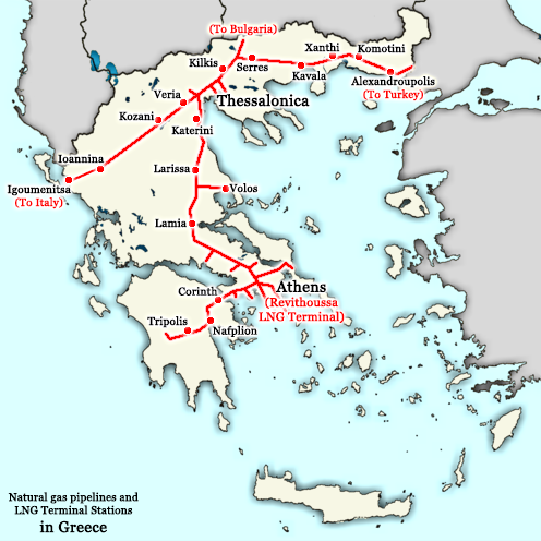
English: A map showing the approximate locations of natural gas pipelines in Greece]]: they run approximately from Alexandroupolis to Thessaloniki and then fork into two directions, one going towards Igoumenitsa (and later Italy) and the other towards Larissa, Lamia, Thiva, Athens, Corinth, Nauplio, and Tripolis. Note: this map also shows the planned Greece-Italy pipeline from Thessaloniki to Igoumenitsa which is not built yet. Greece maintains a powerful energy industry with particular emphasis on natural gas, managed by the DEPA company. This map is an approximation of the natural gas pipelines in Greece, based on information available from http://www.depa.gr/files/downloadables/national-map-gr.pdf
Ελληνικά: Ένας χάρτης που δείχνει στο περίπου τις τοποθεσίες αγωγών φυσικού αερίου της Ελλάδος: τρέχουν από Αλεξανδρούπολη προς Θεσσαλονικη και μετά χωρίζονται σε δυο δρόμους, ένα προς Ιγουμενίτσα (και τελικά Ιταλία) και τον άλλο προς Λάρισα, Λαμία, Θήβα, Αθήνα, Κόρινθος, και Τρίπολη. Σημείωση: ο χάρτης δείχνει και τον αγωγό Ιταλίας-Ελλάδας από Θεσσαλονίκη έως Ιγουμενίτσα που δεν έχει χτιστεί ακόμη. Η Ελλάδα διαθέτει μία παντοδύναμη ενεργειακή οικονομία με ιδιαίτερη έμφαση στο φυσικό αέριο, το οποίο τελεί υπό την διαχείρηση της εταιρείας ΔΕΠΑ. Αυτός ο χάρτης είναι μία ανακριβή απεικόνιση των σωλήνων φυσικού αερίου της Ελλάδος, βασισμένος σε πληροφορίες που υπάρχουν στο http://www.depa.gr/files/downloadables/national-map-gr.pdf |
| Fecha | |
| Fuente | Derivative work based on http://commons.wikimedia.org/wiki/File:Greece_outline_map.png |
| Autor | This derivative work is from NSK Nikolaos S. Karastathis (User:NSK Nikolaos S. Karastathis); the original work upon this derivative work is based on was originally uploaded by ChrisO at en.wikipedia ( http://en.wikipedia.org/wiki/User:ChrisO ) and it was later uploaded on Wikimedia Commons by Sasa_Stefanovic ( http://commons.wikimedia.org/wiki/User:Sasa_Stefanovic ) |
| Permiso (Reutilización de este archivo) |
GFDL |
| Otras versiones | http://commons.wikimedia.org/wiki/File:Greece_outline_map.png |
The original map was released under the GFDL by the author ChrisO at en.wikipedia ( http://en.wikipedia.org/wiki/User:ChrisO ) (Released under the GNU Free Documentation License). This derivative work, therefore, is also released under the same licence, the GFDL (Released under the GNU Free Documentation License).
[[:c:User:{{{1}}}|{{{1}}}]], titular de los derechos de autor de esta obra, la publica en los términos de la siguiente licencia:

|
Se autoriza la copia, distribución y modificación de este documento bajo los términos de la licencia de documentación libre GNU, versión 1.2 o cualquier otra que posteriormente publique la Fundación para el Software Libre; sin secciones invariables, textos de portada, ni textos de contraportada. Se incluye una copia de la dicha licencia en la sección titulada Licencia de Documentación Libre GNU. |
| Este archivo se encuentra bajo la licencia Creative Commons Genérica de Atribución/Compartir-Igual 3.0. | ||
| Atribución: [[:c:User:{{{1}}}|{{{1}}}]] | ||
| ||
| Esta etiqueta de licencia fue agregada a este archivo como parte de la actualización de la licencia GFDL. |
Historial del archivo
Haz clic sobre una fecha y hora para ver el archivo tal como apareció en ese momento.
| Fecha y hora | Miniatura | Dimensiones | Usuario | Comentario | |
|---|---|---|---|---|---|
| actual | 14:22 7 dic 2015 | | 496 × 496 (194 kB) | SilentResident | Improved and updated |
| 18:01 19 ene 2009 |  | 800 × 700 (45 kB) | NSK Nikolaos S. Karastathis | {{Information |Description={{en|1=Greece maintains a powerful energy industry with particular emphasis on natural gas, managed by the DEPA company. This map is an approximation of the natural gas pipelines in Greece, based on information available from h |
Usos del archivo
La siguiente página usa este archivo:
Uso global del archivo
Las wikis siguientes utilizan este archivo:
- Uso en bg.wikipedia.org
- Uso en el.wikipedia.org
- Uso en en.wikipedia.org
- Uso en fr.wikipedia.org
- Uso en he.wikipedia.org
- Uso en it.wikipedia.org
- Uso en ko.wikipedia.org
- Uso en ru.wikipedia.org
- Uso en tr.wikipedia.org
- Uso en uz.wikipedia.org