
Archivo:GrahamLandstubmap.png
No se dispone de una resolución más alta.
GrahamLandstubmap.png (243 × 334 píxeles; tamaño de archivo: 30 kB; tipo MIME: image/png)
Resumen
| Descripción |
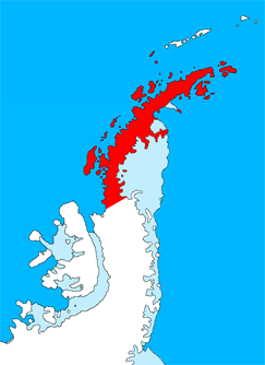
English: Outline map of the Antarctic Peninsula showing Graham Land.
Drawn by me (User:Grutness) based on File:Ant-pen_map.png by Giovanni Fattori. |
| Fecha | 2 de julio de 2011 (fecha original de carga) |
| Fuente | Transferido desde en.wikipedia a Commons. |
| Autor | The original uploader was Grutness de Wikipedia en inglés. |
Licencia

|
Se autoriza la copia, distribución y modificación de este documento bajo los términos de la licencia de documentación libre GNU, versión 1.2 o cualquier otra que posteriormente publique la Fundación para el Software Libre; sin secciones invariables, textos de portada, ni textos de contraportada. Se incluye una copia de la dicha licencia en la sección titulada Licencia de Documentación Libre GNU. |
Registro original de carga
Aquí se muestra la página de descripción original. Los siguientes nombres de usuario se refieren a en.wikipedia.
- 2011-07-02 09:38 Grutness 243×334× (30925 bytes) Outline map of the Antarctic Peninsula showing [[Graham Land]]. Drawn by me (User:Grutness) based on [[:File:Ant-pen_map.png]] by Giovanni Fattori.{{GFDL}}
Historial del archivo
Haz clic sobre una fecha y hora para ver el archivo tal como apareció en ese momento.
| Fecha y hora | Miniatura | Dimensiones | Usuario | Comentario | |
|---|---|---|---|---|---|
| actual | 20:06 9 jul 2011 | | 243 × 334 (30 kB) | MGA73bot2 | {{BotMoveToCommons|en.wikipedia|year={{subst:CURRENTYEAR}}|month={{subst:CURRENTMONTHNAME}}|day={{subst:CURRENTDAY}}}} {{Information |Description={{en|Outline map of the Antarctic Peninsula showing en:Graham Land. Drawn by me (User:Grutness) base |
Usos del archivo
La siguiente página usa este archivo:
Uso global del archivo
Las wikis siguientes utilizan este archivo:
- Uso en az.wikipedia.org
- Uso en bg.wikipedia.org
- Uso en cs.wikipedia.org
- Uso en da.wikipedia.org
- Uso en de.wikipedia.org
- Uso en en.wikipedia.org
- Mount Scott (Antarctica)
- Bowman Coast
- Cuverville Island
- Danco Island
- Charlotte Bay
- Loubet Coast
- Mill Inlet
- Cabinet Inlet
- Cape Alexander
- Cole Peninsula
- Castle Peak (Antarctica)
- Quartermain Glacier
- Quervain Peak
- Aagaard Glacier
- Bigourdan Fjord
- Cape Jeremy
- Weertman Island
- Bennett Islands
- Liard Island
- Devil Island
- Upper Island
- Useful Island
- Mount Zdarsky
- Mount Shackleton
- Shag Rock (Antarctica)
- Shanty Point
- Sharp Glacier
- Mount Shelby
- Mount St. Louis
- Shull Rocks
- Simler Snowfield
- Zilva Peaks
- Saffery Islands
- Index Peak
- Foyn Point
- Haefeli Glacier
- Finsterwalder Glacier
- Avsyuk Glacier
Ver más uso global de este archivo.