
Archivo:G. W. & C. B. Colton & Co. True Southern Pacific Railway c. 1881 UTA.jpg

Tamaño de esta previsualización: 800 × 300 píxeles. Otras resoluciones: 320 × 120 píxeles · 640 × 240 píxeles · 1024 × 384 píxeles · 1280 × 479 píxeles · 2560 × 959 píxeles · 9594 × 3594 píxeles.
Ver la imagen en su resolución original (9594 × 3594 píxeles; tamaño de archivo: 9,22 MB; tipo MIME: image/jpeg)
Resumen
| Título |
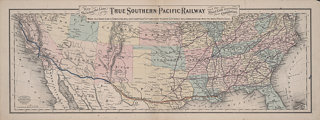
English: Map Showing the Line of the True Southern Pacific Railway and the Short Link necessary for its Completion |
||||||||||||||||||||||||||
| Descripción |
English: The Southern Pacific Railroad, chartered in California in 1865 to build a railroad between San Francisco and San Diego, was purchased in 1868 by the group of California railroad investors known as "the Big Four" – Leland Stanford, Collis P. Huntington, Charles Crocker, and Mark Hopkins – who merged it with their Central Pacific in 1870. By 1877 the S. P. stretched eastward into Arizona. By 1878 Huntington also had heavy investments in the Texas-based Galveston, Harrisburg and San Antonio Railway and the Texas and New Orleans Railroad. By 1881 the S. P. had reached El Paso and had control of both these railroads, the Louisiana Western Railroad Extension Company, and Morgan's Louisiana and Texas Railroad and Steamship Company. In 1883 the Southern Pacific and its affiliates completed yet another transcontinental route in 1883, when the construction crews of the G. H. & S. A. and the S. P. met just west of the Pecos River. By 1900 the Southern Pacific and its affiliates owned more miles of track than any other line in Texas.
|
||||||||||||||||||||||||||
| Fecha | hacia 1881 | ||||||||||||||||||||||||||
| Fuente | UTA Libraries Cartographic Connections: mapa / texto | ||||||||||||||||||||||||||
| Creador |
G. W. & C. B. Colton |
||||||||||||||||||||||||||
| Adquisición |
English: The University of Texas at Arlington Libraries Special Collections |
||||||||||||||||||||||||||
| Geotemporal data | |||||||||||||||||||||||||||
| Map location | Estados Unidos | ||||||||||||||||||||||||||
| Georeferencing | If inappropriate please set warp_status = skip to hide. | ||||||||||||||||||||||||||
| Lugar de publicación | Nueva York | ||||||||||||||||||||||||||
| Archival data | |||||||||||||||||||||||||||
| Colección |
|
||||||||||||||||||||||||||
| Dimensiones | altura: 22,5 cm; ancho: 61,5 cm | ||||||||||||||||||||||||||
| Técnica |
cerograph color litógrafo color |
||||||||||||||||||||||||||
| artwork-references |
Orsi, Richard (2005) Sunset Limited: The Southern Pacific Railroad and the Development of the American West, 1850-1930, Berkeley: University of California Press Peterson, Anne The Southern Pacific Railroad: The Road of a Thousand Wonders, Dallas: DeGolyer Library, SMU, p. 2,005 |
||||||||||||||||||||||||||
Licencia

|
This file was provided to Wikimedia Commons by the University of Texas at Arlington Libraries as part of a cooperation project. The University of Texas at Arlington Libraries is part of the University of Texas at Arlington, a public research university located in Arlington, Texas.
|
Esta obra fue publicada por primera vez antes del 1 de enero de 1929 y es anónima o seudónima por desconocerse su autoría. Por ello está en dominio público en los Estados Unidos, así como en los demás países y áreas donde los términos de derechos de autor de obras anónimas o seudónimas son de 95 años (o menos) tras su publicación.
|
Historial del archivo
Haz clic sobre una fecha y hora para ver el archivo tal como apareció en ese momento.
| Fecha y hora | Miniatura | Dimensiones | Usuario | Comentario | |
|---|---|---|---|---|---|
| actual | 15:34 13 abr 2022 | 9594 × 3594 (9,22 MB) | Michael Barera | == {{int:filedesc}} == {{Map |title = {{en|'''''Map Showing the Line of the True Southern Pacific Railway and the Short Link necessary for its Completion'''''}} |description = {{en|The Southern Pacific Railroad, chartered in California in 1865 to build a railroad between San Francisco and San Diego, was purchased in 1868 by the group of California railroad investors known as "the Big Four" – Leland Stanford, Collis P. Huntington, Charles Crocker, and Mark Hopkins – who mer... |
Usos del archivo
La siguiente página usa este archivo:
Uso global del archivo
Las wikis siguientes utilizan este archivo:
- Uso en de.wikipedia.org
- Uso en en.wikipedia.org
- Uso en fr.wikipedia.org
- Uso en hu.wikipedia.org
- Uso en it.wikipedia.org
- Uso en pt.wikipedia.org