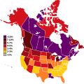
Archivo:French ancestry in the USA and Canada.svg

Tamaño de esta previsualización PNG del archivo SVG: 601 × 600 píxeles. Otras resoluciones: 241 × 240 píxeles · 481 × 480 píxeles · 770 × 768 píxeles · 1027 × 1024 píxeles · 2053 × 2048 píxeles · 1605 × 1601 píxeles.
Ver la imagen en su resolución original ((Imagen SVG, nominalmente 1605 × 1601 pixels, tamaño de archivo: 206 kB))
Historial del archivo
Haz clic sobre una fecha y hora para ver el archivo tal como apareció en ese momento.
| Fecha y hora | Miniatura | Dimensiones | Usuario | Comentario | |
|---|---|---|---|---|---|
| actual | 18:46 10 mar 2021 |  | 1605 × 1601 (206 kB) | Blackberryrose | Fixed Borden Island |
| 11:25 6 ene 2021 |  | 1605 × 1601 (206 kB) | Blackberryrose | Fixed Haida Gwaii | |
| 14:36 9 dic 2019 |  | 1605 × 1601 (206 kB) | Simtropolitan | txt to path | |
| 03:57 9 dic 2019 |  | 1605 × 1601 (187 kB) | Simtropolitan | Reverted to version as of 16:20, 12 November 2019 (UTC); I appreciate the good intentions but they are not added for a reason, the census collects those numbers by response to those identifying "one or more ancestry group", and even notes in the 1990 Census abstract (page III-3) that the response data for those handles reflects a change in the way the census asked questions; ergo the map with these categories combined is double-counting large amounts of people as French is by far the largest... | |
| 15:58 7 dic 2019 |  | 1749 × 1740 (81 kB) | Domen von Wielkopolska | Reverted to version as of 15:56, 7 December 2019 (UTC) | |
| 15:57 7 dic 2019 |  | 1605 × 1601 (187 kB) | Domen von Wielkopolska | Reverted to version as of 16:20, 12 November 2019 (UTC) | |
| 15:56 7 dic 2019 |  | 1749 × 1740 (81 kB) | Domen von Wielkopolska | Great work, but I'm updating because you forgot to include French Canadian and Cajun/Acadian categories from 1990 U.S. census, so percentages are changing in some states after adding up numbers for French and these two categories. Now the border of Louisiana Purchase is better visible, so it makes sense: https://www2.census.gov/library/publications/decennial/1990/cp-s-1-2.pdf | |
| 15:50 7 dic 2019 |  | 1749 × 1740 (81 kB) | Domen von Wielkopolska | Great work, but I'm updating because you forgot to include French Canadian and Cajun/Acadian categories from 1990 U.S. census, so percentages are changing in some states after adding up numbers for French and these too categories. Now the border of Louisiana Purchase is better visible, so it makes sense:<br> https://www2.census.gov/library/publications/decennial/1990/cp-s-1-2.pdf | |
| 16:20 12 nov 2019 |  | 1605 × 1601 (187 kB) | Simtropolitan | User created page with UploadWizard |
Usos del archivo
La siguiente página usa este archivo:
Uso global del archivo
Las wikis siguientes utilizan este archivo:
- Uso en en.wikipedia.org
- Uso en fa.wikipedia.org
- Uso en uk.wikipedia.org
- Uso en zh.wikipedia.org
