
Archivo:France radar 2 dordogne.png
No se dispone de una resolución más alta.
France_radar_2_dordogne.png (657 × 292 píxeles; tamaño de archivo: 343 kB; tipo MIME: image/png)
Resumen
| Descripción |
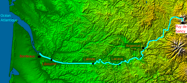
English: Map of Dordogne river made with France viewed by NASA Shuttle radar-imaging.
Français : Carte de la Dordogne faite à partir de l'image radar de la France vue depuis la navette spatiale, par la NASA. |
| Fecha | |
| Fuente | Trabajo propio |
| Autor | Thierry46 |
Licencia
- The purpose of NASA's Earth Observatory is to provide a freely-accessible publication on the Internet where the public can obtain new satellite imagery and scientific information about our home planet. The focus is on Earth's climate and environmental change. In particular, we hope our site is useful to public media and educators. Any and all materials published on the Earth Observatory are freely available for re-publication or re-use, except where copyright is indicated. We ask that NASA's Earth Observatory be given credit for its original materials.
This image uses high-resolution digital topography data from NASA's Shuttle Radar Topography Mission (SRTM) at JPL-Caltech [1]. It is in the public domain in the United States.
|
 | |
| This work was previously under Public Domain, or a Free License. It has been digitally enhanced and/or modified. This derivative work has been (or is hereby) released into the public domain by its author, Sting at the French Wikipedia project. This applies worldwide. In some countries this is not legally possible; if so:
|
Historial del archivo
Haz clic sobre una fecha y hora para ver el archivo tal como apareció en ese momento.
| Fecha y hora | Miniatura | Dimensiones | Usuario | Comentario | |
|---|---|---|---|---|---|
| actual | 19:40 28 ago 2008 | | 657 × 292 (343 kB) | Thierry46 | {{Information |Description={{en|1=Map of Dordogne river made with France viewed by NASA Shuttle radar-imaging. France radar 2.jpg}} {{fr|1=Carte de la rivière Dordogne faite à partir de l'image radar de la France vue depuis la navette spatiale, par |
Usos del archivo
No hay páginas que enlacen a este archivo.
Uso global del archivo
Las wikis siguientes utilizan este archivo:
- Uso en bg.wikipedia.org
- Uso en de.wikipedia.org
- Uso en el.wikipedia.org
- Uso en eo.wikipedia.org
- Uso en fr.wikipedia.org
- Uso en fr.wiktionary.org
- Uso en ja.wikipedia.org
- Uso en ro.wikipedia.org
- Uso en sh.wikipedia.org
- Uso en sr.wikipedia.org