
Archivo:European Middle Neolithic.gif
Tamaño de esta previsualización: 800 × 397 píxeles. Otras resoluciones: 320 × 159 píxeles · 640 × 317 píxeles · 1307 × 648 píxeles.
Ver la imagen en su resolución original (1307 × 648 píxeles; tamaño de archivo: 101 kB; tipo MIME: image/gif)
Resumen

|
File:European-middle-neolithic-en.svg es una versión vectorial de este archivo. Debería usarse esa versión en lugar de este archivo GIF, cuando sea mejor.
File:European Middle Neolithic.gif → File:European-middle-neolithic-en.svg
Para más información, lee Ayuda:SVG. |
 |
.
| Descripción |
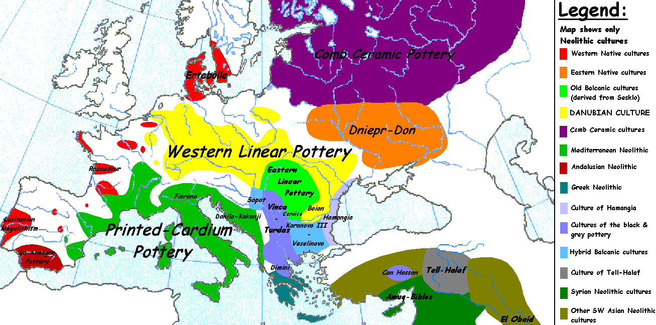
English: Map of the second half European Middle Neolithic at the apogee of Danubian and Mediterranean expansion. (The modification of the original map - Combed pottery, earlier notated as Pitted Ware, see history without respecting the color code of the legend is something that I am not fully satisfied with). |
| Fecha | 5 de abril de 2005 (fecha original de carga) |
| Fuente | Transferido desde en.wikipedia a Commons. |
| Autor | Later versions were uploaded by Clarifer at en.wikipedia. |
| Otras versiones |
[]
|


_en.png)
.png)
.jpg)
Licencia
| Este trabajo ha sido liberado al dominio público por su autor, Sugaar de Wikipedia en inglés. Esto aplica para todo el mundo. En algunos países esto puede no ser legalmente factible; si ello ocurriese: Sugaar otorga a cualquier persona el derecho de usar este trabajo para cualquier propósito, sin ningún tipo de condición, a menos que éstas sean requeridas por la ley. |
Registro original de carga
Aquí se muestra la página de descripción original. Los siguientes nombres de usuario se refieren a en.wikipedia.
- 2005-08-28 13:11 Clarifer 1320×663×8 (106148 bytes) Added the approximate area of the Comb Ceramic culture. Source: National Board of Antiquities, Finland. www.nba.fi
- 2005-04-05 20:12 Sugaar 1320×663×8 (103228 bytes) Map of the second half European Middle Neolithic at the apogee of Danubian and Mediterranean expansion (c. 4500-4000 BCE). Made by [[Sugaar]]. Free use authorized by the author.
Historial del archivo
Haz clic sobre una fecha y hora para ver el archivo tal como apareció en ese momento.
| Fecha y hora | Miniatura | Dimensiones | Usuario | Comentario | |
|---|---|---|---|---|---|
| actual | 06:43 18 abr 2014 | | 1307 × 648 (101 kB) | Spiridon Ion Cepleanu | Neolithic shorelines and banks, little details |
| 00:39 22 mar 2010 |  | 1307 × 648 (101 kB) | Ras67 | cropped | |
| 00:50 14 feb 2007 |  | 1320 × 663 (104 kB) | 32X | Auf eine alte Version zurückgesetzt | |
| 00:49 14 feb 2007 |  | 1320 × 663 (101 kB) | 32X | Original version by Sugaar. | |
| 11:14 31 dic 2005 |  | 1320 × 663 (104 kB) | Glenn | Originally uploaded to en-wiki: Quote: "Map of the second half European Middle Neolithic at the apogee of Danubian and Mediterranean expansion (c. 4500-4000 BCE)." Upload text: "20:12, 5 April 2005 . . Sugaar . . 1320x663 (103228 bytes) (Map of the secon |
Usos del archivo
No hay páginas que enlacen a este archivo.
Uso global del archivo
Las wikis siguientes utilizan este archivo:
- Uso en az.wikipedia.org
- Uso en be.wikipedia.org
- Uso en bg.wikipedia.org
- Uso en bs.wikipedia.org
- Uso en ca.wikipedia.org
- Uso en cs.wikipedia.org
- Uso en da.wikipedia.org
- Uso en da.wikibooks.org
- Uso en de.wikipedia.org
- Uso en en.wikipedia.org
- Uso en et.wikipedia.org
- Uso en fi.wikipedia.org
- Uso en fi.wikibooks.org
- Uso en gl.wikipedia.org
- Uso en he.wikipedia.org
- Uso en hi.wikipedia.org
- Uso en hr.wikipedia.org
- Uso en hu.wikipedia.org
- Uso en it.wikipedia.org
Ver más uso global de este archivo.