
Archivo:Dunas litoral bonaerense.jpg
No se dispone de una resolución más alta.
Dunas_litoral_bonaerense.jpg (639 × 435 píxeles; tamaño de archivo: 57 kB; tipo MIME: image/jpeg)
Resumen
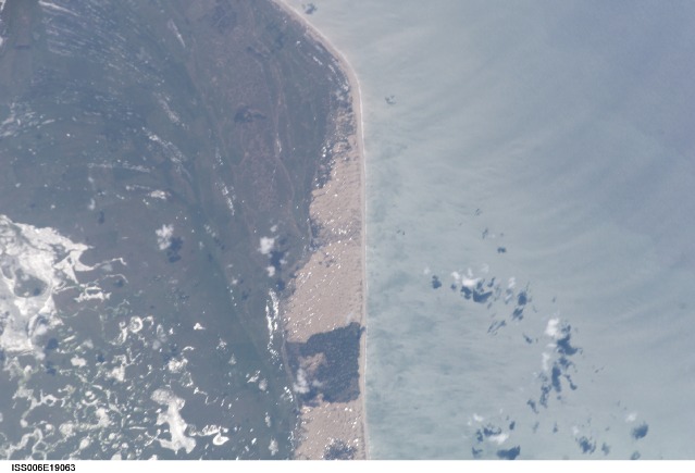
Español: Paisaje de dunas del litoral bonaerense
English: NASA Date: 20030113 (YYYYMMDD) GMT Time: 155306 (HHMMSS)
Nadir Point Latitude: -36.8, Longitude: -58.4 (Negative numbers indicate south for latitude and west for longitude) Nadir to Photo Center Direction: East Sun Azimuth: 8 (Clockwise angle in degrees from north to the sun measured at the nadir point) Spacecraft Altitude: 398 km Sun Elevation Angle: 75 (Angle in degrees between the horizon and the sun, measured at the nadir point)
Orbit Number: 3689| Posición de la cámara | | Ubicación de esta y otras imágenes en: OpenStreetMap |
|---|
Licencia
| Este archivo es de dominio público porque fue creado por la NASA. Las políticas sobre copyright de la NASA estipulan que «el material de la NASA no está protegido con copyright a menos que se indique lo contrario». (Políticas sobre copyright de la NASA o Políticas sobre la utilización de imágenes del Jet Propulsion Laboratory). | ||
 |
Advertencias:
|
Historial del archivo
Haz clic sobre una fecha y hora para ver el archivo tal como apareció en ese momento.
| Fecha y hora | Miniatura | Dimensiones | Usuario | Comentario | |
|---|---|---|---|---|---|
| actual | 03:41 4 jul 2006 | | 639 × 435 (57 kB) | Rosarinagazo | Paisaje de dunas del litoral bonaerense NASA Date: 20030113 (YYYYMMDD)GMT Time: 155306 (HHMMSS) Nadir Point Latitude: -36.8, Longitude: -58.4 (Negative numbers indicate south for latitude and west for longitude) Nadir to Photo Center Direction: East Sun A |
Usos del archivo
Las siguientes páginas usan este archivo:
Uso global del archivo
Las wikis siguientes utilizan este archivo:
- Uso en es.wiktionary.org
- Uso en si.wikipedia.org