
Archivo:Dervish 1900.png
No se dispone de una resolución más alta.
Dervish_1900.png (233 × 253 píxeles; tamaño de archivo: 40 kB; tipo MIME: image/png)
Resumen
| Descripción |
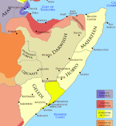
English: The Ogaden region and the Dervish State and the Horn of Africa in 1900 After the Ogaden and Dervish attack upon the Area of Jigjiga The official Dervish borders were: Northwestern, was at Jidali per the excerpt "nearest dervish post was now at Jidali" (source: MOyse-Bartlett, The King's African Rifles page 421) western, was at Badwein per the excerpt "Badwein at the eastern extremity of the Ain Valley, and thence south-west to the southern border at a point where it is intersected by the 46th degree of longitude. It was our object to confine Dervish activities to their side of this line" (Source: Douglas Jardine, 1923, page 250) southern official boundary was at Damot/Do'mo per excerpt "cattle shall not be permitted to pass beyond the pasturage of the wells enumerated hereafter, they are the wells ... to Damot" (source: Douglas Jardine, 1923, page 158) |
| Fecha | |
| Fuente | https://www.pinterest.com/pin/589690144944704455/ |
| Autor | Somaliyeed |

|
Esta imagen debería volverse a crear como imágenes vectoriales SVG. Esto proporciona muchas ventajas, véase Commons:Media for cleanup (en inglés) para más información. Si ya hay una versión SVG de esta imagen disponible, por favor súbala a Commons. Tras subirla, reemplace esta plantilla con la plantilla
{{vector version available|nuevo nombre de imagen.svg}} en esta imagen. |
Licencia
Yo, el titular de los derechos de autor de esta obra, la publico en los términos de la siguiente licencia:
Este archivo está disponible bajo la licencia Creative Commons Attribution-Share Alike 4.0 International.
- Eres libre:
- de compartir – de copiar, distribuir y transmitir el trabajo
- de remezclar – de adaptar el trabajo
- Bajo las siguientes condiciones:
- atribución – Debes otorgar el crédito correspondiente, proporcionar un enlace a la licencia e indicar si realizaste algún cambio. Puedes hacerlo de cualquier manera razonable pero no de manera que sugiera que el licenciante te respalda a ti o al uso que hagas del trabajo.
- compartir igual – En caso de mezclar, transformar o modificar este trabajo, deberás distribuir el trabajo resultante bajo la misma licencia o una compatible como el original.
Historial del archivo
Haz clic sobre una fecha y hora para ver el archivo tal como apareció en ese momento.
| Fecha y hora | Miniatura | Dimensiones | Usuario | Comentario | |
|---|---|---|---|---|---|
| actual | 05:37 14 sep 2023 | | 233 × 253 (40 kB) | CXDS | Reverted to version as of 02:24, 4 November 2022 (UTC) |
| 12:47 29 may 2023 |  | 233 × 253 (48 kB) | Sgottharivuu | east | |
| 19:51 28 may 2023 |  | 233 × 253 (47 kB) | Sgottharivuu | Ogaden states | |
| 18:18 28 may 2023 |  | 233 × 253 (47 kB) | Sgottharivuu | There are no historical records that an annexation of Jigjiga took place. Hence corrected the map | |
| 02:24 4 nov 2022 |  | 233 × 253 (40 kB) | Somaliyeed | Uploaded own work with UploadWizard |
Usos del archivo
La siguiente página usa este archivo:
Uso global del archivo
Las wikis siguientes utilizan este archivo:
- Uso en en.wikipedia.org
- Uso en tr.wikipedia.org