
Archivo:DFW Airport Diagram.svg

Tamaño de esta previsualización PNG del archivo SVG: 378 × 548 píxeles. Otras resoluciones: 165 × 240 píxeles · 331 × 480 píxeles · 530 × 768 píxeles · 706 × 1024 píxeles · 1413 × 2048 píxeles.
Ver la imagen en su resolución original ((Imagen SVG, nominalmente 378 × 548 pixels, tamaño de archivo: 1,55 MB))
Resumen
| Descripción |
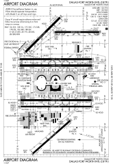
English: FAA Airport Diagram of Dallas-Fort Worth International Airport. |
| Fecha | |
| Fuente |
FAA Airport Diagrams; note that these change every 28 days. Taken from PDF on FAA site and converted to SVG using en:Wikipedia:How to draw SVG circuits using Xcircuit. |
| Autor | Produced by the National Aeronautical Charting Office (NACO), a department of the United States en:Federal Aviation Administration. |
| Posición de la cámara | | Ubicación de esta y otras imágenes en: OpenStreetMap |
|---|
W3C-validity not checked.
Licencia
This image or file is a work of a Federal Aviation Administration employee, taken or made as part of that person's official duties. As a work of the U.S. federal government, the image is in the public domain in the United States.
|
 |
Historial del archivo
Haz clic sobre una fecha y hora para ver el archivo tal como apareció en ese momento.
| Fecha y hora | Miniatura | Dimensiones | Usuario | Comentario | |
|---|---|---|---|---|---|
| actual | 14:07 2 may 2013 | | 378 × 548 (1,55 MB) | Grendelkhan | SVG version of FAA's PDF diagram. |
Usos del archivo
La siguiente página usa este archivo:
Uso global del archivo
Las wikis siguientes utilizan este archivo:
- Uso en ar.wikipedia.org
- Uso en bn.wikipedia.org
- Uso en de.wikipedia.org
- Uso en en.wikipedia.org
- Uso en fa.wikipedia.org
- Uso en fr.wikipedia.org
- Uso en he.wikipedia.org
- Uso en id.wikipedia.org
- Uso en ja.wikipedia.org
- Uso en ru.wikipedia.org
- Uso en simple.wikipedia.org
- Uso en ta.wikipedia.org
- Uso en th.wikipedia.org
- Uso en ur.wikipedia.org
- Uso en vi.wikipedia.org
- Uso en zh.wikipedia.org