
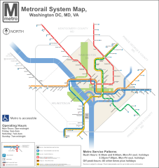
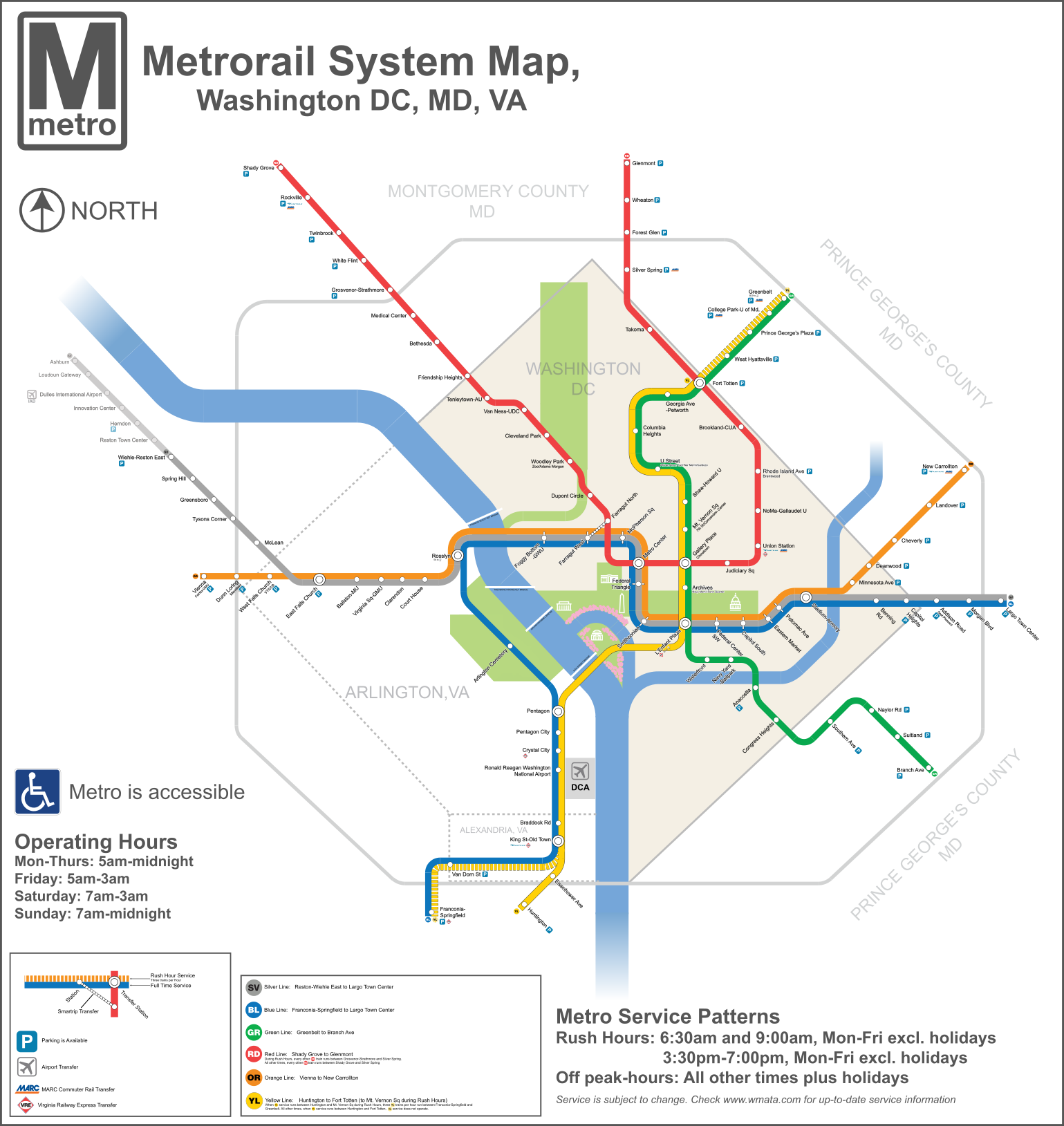
Archivo:DC Metro Map 2013.svg

Tamaño de esta previsualización PNG del archivo SVG: 566 × 599 píxeles. Otras resoluciones: 227 × 240 píxeles · 453 × 480 píxeles · 726 × 768 píxeles · 967 × 1024 píxeles · 1935 × 2048 píxeles · 1539 × 1629 píxeles.
Ver la imagen en su resolución original ((Imagen SVG, nominalmente 1539 × 1629 pixels, tamaño de archivo: 4,48 MB))
Resumen
| Descripción |
English: A redesigned map of the Washington Metro. Created using Adobe Illustrator. This map shows the Rush Plus service details and is designed to be more geographically matched than the current metro map. Two files from Commons were used in the creation of the Map. They are File:WMATA Metro Logo.svg, and File: Amtrak logo.svg |
| Fecha | |
| Fuente | Trabajo propio |
| Autor | VeggieGarden |
Este gráfico vectorial fue creado con Adobe Illustrator.

|
El tamaño de esta imagen SVG puede ser anormalmente grande porque la mayor parte o la totalidad de su texto se ha convertido en trazado en lugar de utilizar el formato más convencional
<text>. A menos que renderizar el texto del archivo SVG produzca una imagen con texto ilegible debido a las limitaciones técnicas, se recomienda encarecidamente cambiar el formato del texto. Si lo hace, ayudaría a facilitar el proceso de localización de esta imagen en otros idiomas y es probable que reduzca el tamaño del archivo significativamente. Se pueden encontrar otros SVG que contienen texto basado en trazados en Category:Path text SVG. Para más información, véase SVG: Fonts (en inglés) y Preparing images for upload: Text (en inglés).
|

|
Licencia
Yo, el titular de los derechos de autor de esta obra, la publico en los términos de la siguiente licencia:
| Este archivo está disponible bajo la licencia Creative Commons Dedicación de Dominio Público CC0 1.0 Universal. | |
| La persona que ha asociado una obra a este documento lo dedica al dominio público mediante la cesión mundial de sus derechos bajo la ley de derechos de autor y todos los derechos legales adyacentes propios de dicha, en el ámbito permitido por ley. Puedes copiar, modificar, distribuir y reproducir el trabajo, incluso con objetivos comerciales, sin pedir aprobación del autor.
|
Historial del archivo
Haz clic sobre una fecha y hora para ver el archivo tal como apareció en ese momento.
| Fecha y hora | Miniatura | Dimensiones | Usuario | Comentario | |
|---|---|---|---|---|---|
| actual | 17:31 3 dic 2015 | | 1539 × 1629 (4,48 MB) | Pi.1415926535 | Reduce height |
| 17:27 3 dic 2015 |  | 1539 × 1779 (4,47 MB) | Pi.1415926535 | Fixed misaligned background | |
| 22:11 2 dic 2015 |  | 1539 × 1779 (4,47 MB) | Pi.1415926535 | Update station names | |
| 21:24 2 dic 2015 |  | 1539 × 1779 (4,48 MB) | Pi.1415926535 | Increase width for better visibility (no other changes) | |
| 09:23 19 ago 2014 |  | 512 × 592 (4,09 MB) | Rcsprinter123 | Cemetery, Mongomery | |
| 02:06 18 oct 2013 |  | 512 × 592 (3,98 MB) | VeggieGarden | Added parking at Wiehle-Reston East Station, fixed "accessible" spelling error | |
| 23:56 16 oct 2013 |  | 512 × 592 (3,86 MB) | VeggieGarden | Fixed More Errors, made the map more readable | |
| 23:56 16 oct 2013 |  | 512 × 592 (3,86 MB) | VeggieGarden | Fixed More Errors, made the map more readable | |
| 23:43 16 oct 2013 |  | 512 × 592 (586 kB) | VeggieGarden | Fixed errors | |
| 23:35 16 oct 2013 |  | 512 × 592 (284 kB) | VeggieGarden | Brand New design, more accurate, addition of Silver Line Phase 1. The map is also easier to understand. |
Usos del archivo
No hay páginas que enlacen a este archivo.
Uso global del archivo
Las wikis siguientes utilizan este archivo:
- Uso en en.wikipedia.org
- Uso en pt.wikipedia.org
- Uso en zh.wikipedia.org