Archivo:Bering Sea ESA376705.jpg

Contenido de la página no disponible en otros idiomas.
De Wikipedia, la enciclopedia libre

Ver la imagen en su resolución original(3903 × 3955 píxeles; tamaño de archivo: 9,89 MB; tipo MIME: image/jpeg)

Resumen

Descripción
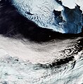
English: The Copernicus Sentinel-3A satellite brings us over the Bering Sea, north of the Alaska Peninsula, on 26 March.

Seasonal sea ice dominates the upper part of the image. Ice plays an important role in the sea’s ecosystem. Growing algae attach to the bottom of the ice; when the ice melts in the spring, it leaves behind a layer of nutrient-rich freshwater on which the algae thrive. Organisms higher up the food chain then eat the algae. In the top-right corner, we can see part of Alaska’s mainland blanketed with snow, as well as Nunivak Island appearing like a massive piece of floating ice. At the centre of the image are the islands of Saint Paul and Saint George – part of the Pribilof Islands. An estimated two million seabirds nest on these islands annually. The swirling clouds on the right side of the image are the result of a meteorological phenomenon known as a von Kármán vortex street. As wind-driven clouds pass over the Unimak Island on the right edge of the image, they flow around the high volcanoes to form the large spinning eddies that can clearly be seen in the image.

This image, also featured on the Earth from Space video programme, was captured by Sentinel-3’s Ocean and Land Colour Instrument, which helps monitor ocean ecosystems, supports crop management and agriculture, and provides estimates of atmospheric aerosol and clouds.
Fecha
Fuente http://www.esa.int/spaceinimages/Images/2017/04/Bering_Sea
Autor European Space Agency
Permiso
(Reutilización de este archivo)
contains modified Copernicus Sentinel data (2017), processed by ESA ,CC BY-SA 3.0 IGO
Otras versiones
Title
InfoField
Bering Sea
System
InfoField
Copernicus
Keywords
InfoField
Sea-ice; Snow; Satellite image; Vortex; Weather systems
Set
InfoField
Earth observation image of the week
Mission
InfoField
Sentinel-3
Activity
InfoField
Observing the Earth

Licencia

w:es:Creative Commons
atribución compartir igual
Este archivo se encuentra bajo la licencia Creative Commons Atribución Compartir-Igual 3.0 IGO.
Eres libre:
  • de compartir – de copiar, distribuir y transmitir el trabajo
  • de remezclar – de adaptar el trabajo
Bajo las siguientes condiciones:
  • atribución – Debes otorgar el crédito correspondiente, proporcionar un enlace a la licencia e indicar si realizaste algún cambio. Puedes hacerlo de cualquier manera razonable pero no de manera que sugiera que el licenciante te respalda a ti o al uso que hagas del trabajo.
  • compartir igual – En caso de mezclar, transformar o modificar este trabajo, deberás distribuir el trabajo resultante bajo la misma licencia o una compatible como el original.

Leyendas

Añade una explicación corta acerca de lo que representa este archivo

Elementos representados en este archivo

representa a

image/jpeg

1dfaae4eca3a46923e9b6c0bee74b2decda2a72b

10 373 538 byte

3955 píxel

3903 píxel

Historial del archivo

Haz clic sobre una fecha y hora para ver el archivo tal como apareció en ese momento.

Fecha y horaMiniaturaDimensionesUsuarioComentario
actual15:06 12 may 2017Miniatura de la versión del 15:06 12 may 20173903 × 3955 (9,89 MB)YannHR from TIFF, 98% compression
12:36 6 may 2017Miniatura de la versión del 12:36 6 may 20171894 × 1920 (3,27 MB)European Space Agency, Id 376705, http://www.esa.int/spaceinimages/Images/2017/04/Bering_Sea, User:Fæ/Project_list/ESA

La siguiente página usa este archivo:

Uso global del archivo

Las wikis siguientes utilizan este archivo: